
Ligonier (Pennsylvania)
| Borough of Ligonier Ligonier |
|||
|---|---|---|---|
|
|||
| Coordinates | 40 ° 15 ′ N , 79 ° 14 ′ W | ||
 Map of Westmoreland County Map of Westmoreland County
|
|||
| Basic data | |||
| Country | United States | ||
| Pennsylvania | |||
| ISO 3166-2 | US PA | ||
| Website | www.ligonier.com | ||
 |
|||
_location_map.svg)
Ligonier is a borough in Westmoreland County , Pennsylvania , United States . The place was settled in the 1760s. In 2010 it had 1,573 inhabitants. The borough is known for the nearby Idlewild Park , one of the oldest amusement parks in America. The Seven Springs Mountain Resort is also nearby. Another tourist attraction is the Fort Ligonier Days festival , a parade and craft market that takes place for three days each fall, and Ligonier Market in summer. Ligonier is part of the Pittsburgh - Metropolitan Statistical Area .
Ligonier also has Fort Ligonier , a reconstruction of a Frontier Fort from the time of the French and Indian War . The main square of the place, the Diamond , has a concert pavilion (bandstand).
geography
The "Borough of Ligonier" is completely enclosed by the Ligonier Township , which is a separate municipality. The borough covers an area of 0.5 sqmi (1.3 km²). The place lies between the folds of the foothills of the Appalachian Mountains , which rise up to 644 m at Sheep Hill ( ⊙ ) in the southeast, or up to approx. 600 m at Rock Hollow ( ⊙ ) in the northwest. In Ligonier, several streams flow to Mill Creek , which drains north and forms a deep gorge at Rock Hollow / Saint Clair Hollow . US Highway 30 also follows this route .
history
In 1758 the British launched a major campaign to expel the French troops from the passes of the Ohio River ("Forks of the Ohio", now the Pittsburgh area ). The place at Loyalhanna Creek was the place of the westernmost camp before reaching the Ohio. The British maintained a large army camp here, a mobile city with 6,000 soldiers, so to speak, making the place temporarily the most populous place in Pennsylvania after Philadelphia . The fort was named "Fort Ligonier" after John Ligonier , a British nobleman of French origin who served with the rank of Field Marshal in the British Army . Later the name of the settlement that arose around the fort was shortened to Ligonier.
In 1817 the Philadelphia-Pittsburgh Turnpike was completed, a gravel road and forerunner of today's US Route 30 . Fort Ligonier was an important resting place for travelers and with this in mind, an enterprising settler, John Ramsay (also: Ramsey) designed the street map, including the main square, now known as the "Diamond". Originally the city was named Ramseytown and later moved to Wellington (after Duke of Wellington ). In the end, the current name remained. The place prospered for several decades. On April 10, 1834 Ligonier was "incoporated" (constituted) as Borough.
In 1852, however, the Pennsylvania Railroad was completed, bypassing Ligonier and instead passing through the settlements of Bolivar and Latrobe . The traffic switched from horse-drawn carts to the railroad and gave the place a population decline of up to 350 inhabitants (census of 1860).
Ligonier received a new boost when the Ligonier Valley Railroad was completed in 1877, which connected the place to Latrobe, where connections to the Pennsylvania Railroad were available. The Ligonier Valley Railroad also enabled the removal of wood, coal and rubble that were mined in the Ligonier Valley . This once again accelerated the development of the place. The rail link also made it possible for Pittsburgh citizens to visit Ligonier and a tourism industry emerged as a summer resort. Some of the major changes in the place date from this time. In 1894 the Diamond, which until then had been used as a corral for horses and wagons, was redesigned into a park with a concert pavilion. A large hotel, Hotel Breniser, was built in 1900 where the town hall now stands. From 1909 to 1910, the Ligonier Valley Railroad built a neat station and administration building that can still be seen today at 339 West Main Street.
In 1952, the Ligonier Valley Railroad ended due to overexploitation of the timber industry, decline in the coal industry and increasing losses in passenger transport due to competition from passenger vehicles.
The Pittsburgh, Westmoreland and Somerset Railroad was a second railway company that Ligonier ran between 1899 and 1916, albeit with less success than the Ligonier Valley Railroad.
Ligonier has three buildings on the National Register of Historic Places : Fort Ligonier (216 South Market Street); Ligonier Historic District , around the Diamond and the oldest parts of the borough; as well as the demolished Ligonier Armory .
Ligonier and the surrounding area are strongly associated with the Mellon family, a banker dynasty who still own large estates in the area. The Huntland Downs Estate alone covers 30,000 acres (121 km² ) and forms the heart of Mellon Land Holdings .

Former train station, now School District Offices
Fort Ligonier

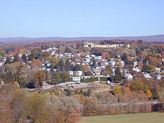
Town center of Ligonier with the Town Hall in the background.


Demographics
According to the Census of 2000, 1,695 people lived in 827 households and 459 families in the borough. The population density is 1,335.6 E / km². The racial composition consists of 99.76% whites, 0.06% Asians and 0.18% of mixed races another 0.35% are Hispanics (Latinos).
Individual evidence
- ↑ American FactFinder. US Census Bureau 2010.
- ^ Metropolitan Areas and Components. Population Division, US Census Bureau 1999.
- ↑ Census.gov. United States Census Bureau , US Gazetteer files: 2010, 2000, and 1990.
- ^ Henry Gannett: The Origin of Certain Place Names in the United States. US Government Printing Office 1905: 186
- ^ Salley Shirey: Ligonier Valley. Arcadia Publishing, Mount Pleasant, South Carolina 2001: 27. ISBN 0-7385-0535-8
- ^ History - Ligonier Valley Chamber of Commerce. 2017-08-07.
- ^ A b National Register of Historical Places - Ligonier Historic District. 2008-05-04 PDF In: ARCH: Pennsylvania's Historic Architecture & Archeology, Pennsylvania Museum and Historical Commission.
- ^ Ligonier Valley Rail Road Association.
- ^ Rachel E. Smith: Latrobe and the Ligonier Valley. Arcadia Publishing, Charleston , South Carolina 2008: 66. ISBN 978-0-7385-5729-8
- ^ National Register Information System . In: National Register of Historic Places . National Park Service . Retrieved July 9, 2010.
- ↑ Factfinder2.gov. United States Census Bureau .
- ↑ American FactFinder.