
Lindenberg (Mühltal)
| Lindenberg | ||
|---|---|---|
| height | 254.1 m above sea level NHN | |
| location | Hessen , Germany | |
| Mountains | Forecrops of the Odenwald | |
| Coordinates | 49 ° 49 '53 " N , 8 ° 40' 57" E | |
|
||
| rock | Crystalline Odenwald - Frankenstein Complex | |
| Age of the rock | about 360 million years | |

The Lindenberg is a mountain in the north-western Odenwald, west of Trautheim .
description
The 251.1-meter-high mountain in the forest district Mühltal is heavily wooded. The listed forest pavilion on the Lindenberg (also: Lindentempel) is located on the southern slope of the Lindenberg .
Toponyms
- undated: Lindenberg
- today: Lindenberg
etymology
Old High German linta meaning linden tree (Tilia ulmifolia) . Middle High German linde meaning linden tree (Tilia ulmifolia). The name refers to a piece of forest that was mainly covered with linden trees; or on a single linden tree in the village or in the field (which has often been a meeting place and court of law since ancient times ).
Picture gallery
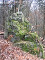
Lindenberg rock on the Kirchberg-Lindenberg ridge (slate gneiss and Hornfelse between Hornblende diorite and biotite diorite, 2014)
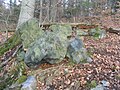
Rock group of the Kirchberg-Lindenberg ridge (2015)

Waldpavillon am Lindenberg (2016)


See also
Web links
Individual evidence
- ↑ City Atlas Darmstadt and Surroundings, Official City Map Darmstadt, Surveying Office of the City of Science Darmstadt, Cartography Department, 2016, p. 40
- ↑ Hans Ramge et al .: Südhessisches Flurnamenbuch , Hessische Historische Kommission Darmstadt, 2002, ISBN 3-88443-045-9 , p. 645ff.