
Liperi
| coat of arms | map |
|---|---|

|

|
| Basic data | |
| State : |
|
| Landscape : | North Karelia |
| Administrative community : | Joensuu |
| Geographical location | 62 ° 32 ' N , 29 ° 23' E |
| Surface: | 1,161.24 km² |
| of which land area: | 726.81 km² |
| of which inland waterways: | 434.43 km² |
| Residents : | 12,145 (Dec. 31, 2018) |
| Population density : | 16.7 inhabitants / km² |
| Municipality number : | 426 |
| Postcodes : | 83100 |
| Language (s) : | Finnish |
| Website : | www.liperi.fi |
Liperi [ ˈlipɛri ] is a municipality in eastern Finland with 12,145 inhabitants (as of December 31, 2018). It is in the countryside of North Karelia on the border with Savo 20 km west of Joensuu .
The municipality is strongly characterized by agriculture and is known as the "granary of North Karelia". The numerous lakes and nature make Liperi a popular holiday destination. There are a total of 3000 summer houses in the community . Liperi has benefited from its proximity to Joensuu, the largest city in the region. In contrast to many other municipalities in North Karelia, the population growth is positive. The population is mainly divided between the three settlement centers Liperi, Viinijärvi and Ylämylly. The parish of Liperi is located on a peninsula between the lakes Pyhäselkä, Ukonselkä and Heposelkä at the northern end of the Saimaa lake area. Ylämylly is located in the neighborhood of Joensuu at the northern end of Lake Pyhäselkä. The road from Joensuu to Kuopio passes Ylämylly as well as Viinijärvi. In addition to the three main towns, the municipality includes the villages of Ahonkylä, Honkalampi, Jyri, Kaarnalampi, Kaatamo, Kompero, Käsämä, Leppälahti, Liperinsalo, Mattisenlahti-Puromäki, Puoliväli, Ruokalahti, Salokylä, Tutjunniemi and Vaivara-Härkinvaivio-Härkinvaivio.
The etymology of the name Liperi is not entirely clear. It probably comes from the Russian word липа lipa for "linden tree". The Liperi Lutheran parish was founded in 1630. It initially included the municipalities of Kuusjärvi ( Outokumpu ), Kontiolahti , Kaavi and Polvijärvi . The four ends of the red cross in the coat of arms of Liperi represent these communities that broke away from Liperi in the 19th century.
Liperi has community partnerships with Orsa ( Sweden ), Saku ( Estonia ), Rendalen ( Norway ), Büchen ( Germany ) and Sejlflod ( Denmark ).
coat of arms
Description of the coat of arms : A red cross hovers in the silver shield .

Liperi Church
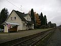
Viinijärvi railway station

Lake landscape near Liperi


Sons and daughters
- Martti Lappalainen (1902–1941), cross-country skier
- Maija Holopainen (* 1978), biathlete
Web links
Individual evidence
- ↑ Maanmittauslaitos (Finnish land surveying office): Suomen pinta-alat kunnittain January 1, 2010 . (PDF; 199 kB)
- ↑ Statistical Office Finland: Table 11ra - Key figures on population by region, 1990-2018
Ilomantsi | Joensuu | Juuka | Kitee | Kontiolahti | Lieksa | Liperi | Nurmes | Outokumpu | Polvijärvi | Rääkkylä | Tohmajärvi