Lieksa
| coat of arms | map |
|---|---|

|

|
| Basic data | |
| State : |
|
| Landscape : | North Karelia |
| Administrative community : | Pielinen Karelia |
| Geographical location | 63 ° 19 ′ N , 30 ° 1 ′ E |
| Surface: | 4,067.65 km² |
| of which land area: | 3,418.54 km² |
| of which inland waterways: | 649.11 km² |
| Residents : | 11,098 (Dec. 31, 2018) |
| Population density : | 3.2 inhabitants / km² |
| Municipality number : | 422 |
| Postcodes : | 81700-81720 |
| Language (s) : | Finnish |
| Website : | lieksa.fi |
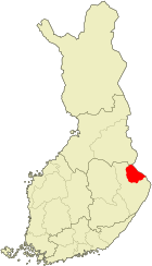
Lieksa [ ˈliɛksɑ ] is a city in eastern Finland with 11,098 inhabitants (as of December 31, 2018). It lies on the border with Russia in the countryside of North Karelia on the eastern shore of Pielinen . Around two thirds of Lieksa's population live in the church village of Lieksa at the mouth of the Lieksanjoki River in the Pielinen.
Lieksa is known for its nature. The extensive urban area of Lieksa includes the 347 meter high Koli mountain, which is considered the Finnish “ national landscape” because of the spectacular view over the Pielinen . The forests in the east of Lieksa are accessible by hiking trails. Around 25 km northeast of the city center and in the immediate vicinity of Fort Ringsa are the rapids of Ruunaa, which are suitable for rafting . The 105 km² Patvinsuo National Park is located in the swamp and jungle landscape in the southeast of Lieksa.
Sights in the church village of Lieksa are the open-air museum Pielisen museo and the modern church. The open-air museum includes 70 historic wooden houses with authentic furnishings and an exhibition building in which the local history is presented. The modern Lieksa Church was built in 1982. The previous building by Carl Ludwig Engel burned down in 1979. In summer, the Lieksan vaskiviikot brass music festival takes place in Lieksa .
In 1653, the Swedish Governor General Per Brahe the Younger founded a town called Brahea on the site of Lieksa . Brahea was given up in the same century. In the 1870s, Lieksa developed again into the main town in the vicinity thanks to the timber rafting on Lieksanjoki. In 1936 Lieksa became a market town, in 1973 the town of Lieksa was created through the merger of the market town of Lieksa and the municipality of Pielisjärvi. In the 1960s Lieksa had 26,000 inhabitants, since then the number of inhabitants has been falling constantly.
Of the 11,297 inhabitants at the end of 2017, 7,162 lived in the urban area of Lieksa, a further 691 in Pielisjärvi, 3,329 were spread over sparsely populated areas, the coordinates of 115 were unknown. The villages in the area are Egyptinkorpi, Hattusaari, Hattuvaara, Höntönvaara, Hörhö, Jaakonvaara, Jamali, Jongunjoki, Kelvä, Kitsinvaara, Koli, Kontiovaara, Kuorajärvi, Kylänlahti, Lamminkylä, Lapalie, Oähtajmäki, Pähtankosvaara, Mätjankosvaara , Puso, Romppala, Ruunaa, Saarivaara, Keträvaara, Savijärvi, Siikavaara, Sikovaara, Sokojärvi, Sokovaara, Surpeenvaara, Uusikylä, Varpanen, Vieki, Viensuu, Vuonisjärvi and Vuonislahti. This area is extensive; Hattuvaara, in the extreme southeast, is 95 kilometers from the city center.
The route from Joensuu via Lieksa to Nurmes is used by passenger trains as line 14A; road 73 has been running parallel since the 1970s .
Sons and daughters
- Ilmari Juutilainen (1914–1999), fighter pilot
- Leo Sario (1916–2009), mathematician
- Jaakko Tallus (* 1981), Nordic combined athlete
- Akseli Lajunen (* 1982), Nordic combined athlete and ski jumper
- Eppu Väänänen (* 1988), biathlete
Web links
Individual evidence
- ↑ Maanmittauslaitos (Finnish land surveying office): Suomen pinta-alat kunnittain January 1, 2010 . (PDF; 194 kB)
- ↑ Statistical Office Finland: Table 11ra - Key figures on population by region, 1990-2018
- ↑ Geopostcodes - Lieksa