List of cultural monuments in Polch
The list of cultural monuments in Polch includes all cultural monuments of the Rhineland-Palatinate city of Polch, including the districts of Kaan , Nettesürsch and Ruitsch . The basis is the list of monuments of the state of Rhineland-Palatinate (as of September 25, 2017).
Polch
Monument zones
| designation | location | Construction year | description | image |
|---|---|---|---|---|
| Monument zone at the train station | At Bahnhof 1, 5/7, Bahnhofstrasse 34, 35 location |
around 1900/10 | Bahnhof (Am Bahnhof 5/7), around 1904/05; At station 1: originally probably a residential building for railway employees; former post office (Bahnhofstrasse 35): neo-baroque gable projectile building; belonging to Bahnhofstrasse 34: train station restaurant, brick building, all around 1900/10 | |
| Monument zone cemetery with St. George's Church | St. Georgenstrasse location |
around 1200 | Georgskirche three-aisled transept-free Romanesque basilica, around 1200, possibly older, upper storey with oculi, probably shortly after 1739, furnishings; Cemetery: laid out in 1806, 88 grave crosses, 16th and 17th centuries; Stations of the Cross: wayside shrine, embedded in the wall, reliefs, 18th century; Neo-Gothic grave crosses in front of the chapel, late 19th or early 20th century; neo-Gothic cemetery cross, 19th century; War memorial, 1950s; belonging to: Graves of Berressen-Loch family in 1925, Nell family in 1927, Hermen family in 1929, Reth family, 1930s; War memorial 1864, 1866, 1870/71: Obelisk with eagle, flanked by lions on pedestals, 1906 |
 more pictures more pictures
|
Individual monuments
| designation | location | Construction year | description | image |
|---|---|---|---|---|
| Wayside cross | Albert-Lortzing-Straße, at No. 10/12 location |
17th or 18th century | Way cross, niche type, 17th or 18th century | |
| Residential building | At the station 1 location |
around 1900/10 | single-storey hipped roof building, basalt base, historicizing-romantic style, around 1900/10 |

|
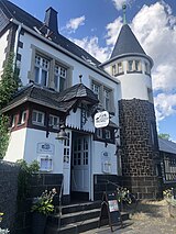
| Polch station | At the train station 5/7 location |
around 1904/05 | multi-part plastered building, loading station, partly half-timbered, Art Nouveau door, around 1904/05 |
|
| Fountain | Corner of Bachstrasse and Kehrstrasse location |
1854 | Fountain, 1854 |

|
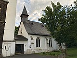
| Hospital chapel St. Josef | Bachstrasse 21 location |
neo-Gothic hall building; neo-Gothic statue of Joseph; Overall structural system with the former St. Josef Hospital, today the Caritas social station |
|
|
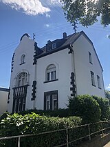
| villa | Bahnhofstrasse 33 location |
around 1900/10 | neo-baroque villa, art nouveau ornaments, around 1900/10, garden fence; Overall system |
|
| Post office | Bahnhofstrasse 35 location |
around 1900/10 | former post office; neo-baroque plastered building, basalt base, around 1900/10 |

|
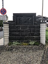
| monument | Bahnhofstrasse, corner of Ackerstrasse Lage |
1920s | Monument to the mothers; “1914/18 Sons of Maifeld commemorates the deeds of their mothers”, relief with three mothers, 1920s |
|
| Wayside cross | Bahnhofstrasse, corner of Viedelstrasse location |
Wayside cross |

|
|
| chapel | In the bee garden 2 location |
1881 | neo-Gothic chapel, 1881; Way Cross, 1785 | |
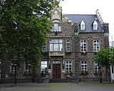
| town hall | Marktplatz 4 location |
1859 | Quarry stone construction, Ecktourellen, 1859, architect Hermann Nebel |
|
| Courtyard of the St. Matthias Abbey | Marktstrasse 2/4 location |
1748 | three-wing baroque complex; Baroque Adelshof, hipped mansard roof, marked 1748; Homestead, corner building marked 1755, separate plastered buildings, courtyard portal; overall structural system | |
| Catholic parish church St. Stephan and Georg | Marktstrasse 6 location |
1849-1852 | neo-Gothic three-nave hall church, 1849–1852, architect Hermann Nebel , Koblenz, plans 1847/48 by Johann Claudius von Lassaulx ; Stephen portal |
 more pictures more pictures
|
| Residential building | Marktstrasse 11 location |
1849 | Plastered building, rustic plinth, marked 1849 | |
| former synagogue | Ostergasse 11 location |
1877 | former synagogue, marked 5637 (= 1877), corner turret and arched window |
 more pictures more pictures
|
| relief | Ostergasse, at No. 15 location |
18th century | Relief, 18th century | |
| Residential building | Pastorstrasse 1, Laßportstrasse 17 location |
17th or 18th century | Half-timbered semi-detached house, clad, half-hip roof, essentially from the 17th or 18th century | |
| Residential building | Pastorstrasse 22 location |
19th century | Half-hip roof building, 19th century | |
| Wayside cross | St. Georgenstrasse, at No. 39 location |
1742 | Wayside cross, marked 1742 | |
| Wayside shrine and wayside cross | St. Georgenstrasse, at No. 52 Lage |
18th and 19th centuries | Wayside shrine with niche and relief, 19th century; Wayside cross, marked 1724 | |
| Crosses | St. Georgenstrasse, corner of Blumenbergstrasse location |
1593 | Cross, marked 1593; Way cross, niche type, marked 1946 | |
| Wayside shrine and cross | Vormaystrasse, at No. 22a Lage |
1789 | Wayside shrine, brick; Cross, marked 1789 | |
| signpost | at the western exit of the village on the L 52 location |
in the middle of the 19th century | Signpost; small obelisk, mid-19th century |

|
| chapel | outside the city | 18th century | Chapel, plastered building, 18th century | |
| Wayside cross | north of the city | 1766 | Wayside cross, marked 1766 |

|
| chapel | southeast of the city near the Neumühle location |
1881 | Chapel; Plastered building, cross from 1881 |

|
| Kurbenhof | west of the city location |
18th century | essentially baroque four-sided courtyard, originally three-sided courtyard; Hipped roof construction, several barns; Chapel, marked 1720, baroque hall building |

|
| Wayside cross | west of the city near the Kurbenhof | 1809 | Wayside cross, marked 1809 | |
| Wayside cross | west of the city near the Kurbenhof | 1781 | Way cross, niche type with relief, marked 1781 | |
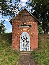
| Water tank | west of the city near the L 52 location |
1896 | Water tank, brick building, marked 1896 |
|
| Wayside cross | west of the city near the L 52 location |
1716 | Road cross, basalt, marked 1716 |

|
Kaan
Individual monuments
| designation | location | Construction year | description | image |
|---|---|---|---|---|
| Catholic branch church Christ König | Bergstrasse location |
1929-1931 | Hall building, basalt quarry stone, separate tower, 1929–1931 |
 more pictures more pictures
|
| Wayside cross | Rüberer Strasse, corner of Auf Kraus Lage |
1648 | Way cross, niche type, marked 1648 | |
| Wayside cross | northeast of the village on the K 48 location |
Wayside cross | ||
| Wayside cross | southeast of the town on the K 46 location |
1698 | Way cross, niche type, marked 1698 |
Nice nice
Individual monuments
| designation | location | Construction year | description | image |
|---|---|---|---|---|
| Nettesürscher Hof | Nettersürsch 1/3 layer |
19th century | Hofreite; Half-hip roof building, 19th century; Mansard roof building, 1920s, barns; Chapel, 19th century, overall structure | |
| Margaretha pit | north of the village location |
19th and 20th centuries | Winding tower, extensions, 19th and 20th centuries; 350 m deep shaft formerly the deepest slate mine in Germany | |
| Railway viaduct | west of the town, the Nettetal spanning position |
before 1904 | Railway viaduct; Six-arch basalt lava house installation, before 1904 (see also Mayen-Hausen ) |
Ruitsch
Individual monuments
| designation | location | Construction year | description | image |
|---|---|---|---|---|
| St. Cruzis Chapel | Hauptstrasse 20 location |
1679 | Hall building, marked 1679, extension 1923; Coat of arms in the lintel, inscribed 1555 |
 more pictures more pictures
|
| Crosses | Main street, at No. 20 location |
16th to 18th century | Wayside cross, marked 1704; Grave cross, marked 1692; Wayside shrine, ladle shape, probably from the 16th century | |
| War memorial | southwest of the village on the cemetery (main street) location |
around 1920 | War memorial, large relief plate with an iron cross | |
| Wayside cross | southwest of the location |
18th century | Wayside cross, 18th century |
literature
- General Directorate for Cultural Heritage Rhineland-Palatinate (Ed.): Informational directory of cultural monuments in the Mayen-Koblenz district (PDF; 5.8 MB). Mainz 2017.
Web links
Commons : Cultural Monuments in Polch - Collection of images, videos and audio files