List of natural monuments in Zwickau
The list of natural monuments in Zwickau names the natural monuments in Zwickau in the Saxon district of Zwickau .
list
This list differentiates between area natural monuments (FND) with an area of up to 5 hectares (even larger in the case of ordinance under GDR law), geological natural monuments (gND) and individual natural monuments (ND).
| image | number | Type | designation | District | position | description | regulation |
|---|---|---|---|---|---|---|---|
| 36-FND1 | FND | Former pit 2 | Oberrothenbach | location | 8.5 ha | 1983 | |
| 36-FND2 | FND | Bird sanctuary | Schneppendorf | location | 2.6 ha | 1989 | |
| 36-FND3 | FND | Bee pasture | Schneppendorf | location | 0.8 ha | 1989 | |
| 36-FND4 | FND | The consequence | Hartmannsdorf ; Werdau - Königswalde | location | 5.5 ha | 1983 | |
| 36-FND5 | FND | Loam residue hole fire | Marienthal | location | The approximately 4.3 hectare area is located on the western city limits. On the watershed between Mulde and Pleiße, material for making bricks was extracted. The remains of the unfilled former loam pit and a small standing water with the surrounding fallow land form a valuable secondary biotope . They are amphibian spawning grounds for crested newt, mountain newt, pond newt, natterjack toad, common toad, small water frog, pond frog and generally an island biotope in the partly densely populated area. | 1995 | |
| 36-FND6 | FND | Orchideenwiese main cemetery | Zwickau | location | On the 300 m² area designated as a natural monument there is a large occurrence of the broad-leaved sitter ( Epipactis helleborine ), which is on the Red List of the Free State . The area should not be covered with graves. As a maintenance measure, mowing should be carried out before budding and after the seeds have ripened. | 1985 | |
| 36-FND7 | FND | Maxhütte pond area | Marienthal | location | The approximately 4.3 hectare wetland in the west of the city is named after the steel mill in Maxhütte , which was closed in 1930 . During the Second World War, numerous craters were blown up during air raids on the nearby aircraft hangar on the grassland of the industrial wasteland, 25 of which were not filled. They have developed into valuable small and micro bodies of water. As a species protection project, additional spawning waters, dead wood hedges and plantings have been created since the 1990s. | 2000 | |
| 36-ND2 | gND | Granite boulder | Zwickau | location | The boulder, which weighs around 1 ton, probably came to its place of discovery in the Knappengrund erosion valley east of the city center of Zwickau with the ice from the Elster Ice Age. The round stone is an alkali granite to syenogranite. It contains u. a. Minerals such as plagioclase , alkali feldspar , quartz , biotite , zirconium , titanite and apatite . The origin of the carved inscription " RAPAKIVI ALANDS ISLANDS" is not known. | 2000 | |
| 36-ND3 | gND | Melaphyr slope | Oberhohndorf | location | Two sub-areas with a total of 4.9 hectares. The Melaphyr is a volcanic outgrowth rock formed about 290 million years ago in the Lower Red of the Vorerzgebirge depression . In a section of the south-eastern stone wall there is a 10 to 20 cm thick brecciated layer . The entire area of the Melaphyr , which is open to two allotment gardens, and the 150 m long steep slope in the southeast are protected . | 2000 | |
| 36-ND4 | gND | Diabase and limestone quarry | Oberplanitz | location | 1.1 ha. Two abandoned quarries in the LSG "Am Kreuzberg". They were of particular importance for economic development from the 17th century. As clues they document the geological development in the Devonian . | 2000 | |
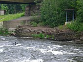
| more pictures | 36-ND5 | gND | Coal outcrop (soot coal seam) | Bockwa , Cainsdorf | location | 3.2 ha area. Outcrop on the banks of the Mulden on both sides upstream of the Cainsdorfer Bridge. Here the "soot coal seam" and the directly hanging and lying upper carbon layers are exposed . | 2000 |
| ND | White elm | Zwickau | location | The white elm in the backyard at Walther-Rathenau-Straße 6 had a trunk circumference of 5.45 m and a crown diameter of 27 m. Since the tree was missing, the felling was approved. | 1996 | ||
| ND | Pedunculate oak Amalienstraße | Zwickau | location | Striking English oak in the center of Zwickau, Amalienstraße, corner of Humboldtstraße. The approximately 16 m high tree had a trunk circumference of 3.96 m in 2015. | 1988 | ||
| 36-ND8 | ND | Plane tree park street | Zwickau | location | The plane tree planted around 1855 in the entrance area of the senior citizens' residential center Parkstrasse 14. In 2015 the tree was around 26 m high. It had a trunk circumference of 4.21 m and a crown diameter of about 21 m. Several fuses have already been built into the crown. | 1983 | |
| 36-ND9 | ND | Sycamore stoneware factory | Zwickau | location | The 23 m high tree with a trunk circumference of 4.20 m, which was planted around 1865, is probably a cross between an oriental and an occidental plane tree. Several fuses were built into the crown with a diameter of 23 m. | 1983 | |
| 36-ND10 | ND | Tulip tree Crimmitschauer Strasse | Weissenborn | location | The tree in a private park at 108 Crimmitschauer Strasse was planted around 1905. In 2015 it was about 25 m high, had a trunk circumference of 2.68 m and a crown width of 15 m. | 1983 | |
| 36-ND11 | ND | Muldestrasse tulip tree | Bockwa | location | The distinctive tree with strong side branches on a company site at 63 Muldestrasse was planted around 1865. In 2015 it had a trunk circumference of 3.02 m. | 1983 | |
| 36-ND12 | ND | Bald cypress in the former botanical garden | Zwickau | location | 1983 | ||
| 36-ND13 | ND | Pedunculate Oak Botanical Garden | Zwickau | location | 1983 | ||
| 36-ND14 | ND | Tree hazel botanical garden | Zwickau | location | 1983 | ||
| 36-ND15 | ND | Ash on the Bachweg | Moselle | location | The 24 m high ash, planted around 1840, had a trunk circumference of 3.88 m in 2015. In 1988 the tree was considered the strongest ash in the Zwickau-Land district . | 1963 | |
| 36-ND17 | ND | Hutung oaks | Niederplanitz | location | The 8 pedunculate oaks on the Planitzbach were estimated to be 250 to 300 years old in 1988. The former hat trees are in the "Am Kreuzberg" nature reserve . In 2015 they had trunk circumferences between 3.25 m and 4.58 m. | 1988 | |
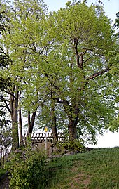
| more pictures | 36-ND18 | ND | Echo (7 linden trees) | Rottmannsdorf | location | A group of 7 winter linden trees planted in a circle around 1900. 14 m to 18 m high, trunk circumference 0.96 m to 2.24 m. The vantage point above the Rottmannsdorf cemetery was formerly called "Alberthöhe" and until 1994 "August-Bebel-Höhe". | 1964 |
| 36-ND19 | ND | 3 Ginkgos Botanical Garden | Zwickau | location | 1983 | ||
| 36-ND20 | ND | 2 yew botanical garden | Zwickau | location | 1983 | ||
| 36-ND21 | ND | Avenue of red oaks | Zwickau | location | Avenue of 82 red oaks on both sides of August-Bebel-Straße, between Lessingstraße and Osterweihstraße. The trees planted in the 1930s were between 14 and 19 m tall in 2015. | 1983 | |
| 36-ND22 | ND | Plane tree avenue | Zwickau | location | The row of 17 old and one replanted plane tree on Lessingstrasse forms the northern edge of the Platz der Völkerfreundschaft. The old trees, which were probably planted before the First World War, were between 16 m and 21 m high in 2015. Their trunks were 1.43 m to 2.60 m in circumference. | 1983 | |
| 36-ND23 | ND | Melanchthon oak | Moselle | location | The pedunculate oak on Dänkritzer Strasse was planted by school children in front of the parish apartment in 1830 on the occasion of the 300th anniversary of the Augsburg Confession . The approximately 20 m high tree had a trunk circumference of 5.18 m and a crown diameter of about 19 m in 2015. The central trunk has been removed, the treetop has already been shortened several times to ensure traffic safety. | 1940 | |
| 36-ND24 | ND | Pedunculate oaks on Cainsdorfer Strasse | Oberplanitz | location | Two English oaks planted around 1860. Trunk circumference 3.50 m and 4.00 m, height 13 m and 17 m. The trees have grown into the retaining wall of Cainsdorfer Straße. The treetops have been shortened several times for safety reasons. | 1956 | |
| 36-ND25 | gND | Bad well | Marienthal | location | 0.21 ha. The approximately 400 year old and 17 m deep well with an earth tower is the remains of an old fortification. The well preserved in its natural state, with a diameter of about 7 m and not lined, is located in Rotliegend. The earth tower with an area of approximately 14 × 15 m has a height of 3.5 m. The tower is surrounded by a trench about 3 m wide and 1.20 m deep. | 1956 |
See also
Web links
Commons : Natural monuments in Zwickau - collection of images
- Nature conservation in ZwickauGIS
- Environmental calendar 2016: Zwickau's tree natural monuments (PDF)
Individual evidence
- ↑ Nature conservation in ZwickauGIS , accessed on July 25, 2020
- ↑ a b c d e area natural monuments , district of Zwickau, accessed on July 25, 2020
- ↑ CITY ZWICKAU: FIND "CLAY REST HOLE BRAND" IN MARIENTHAL , accessed on July 25, 2020
- ↑ CITY OF ZWICKAU: FND "ORCHIDEENWIESE HAUPTFRIEDHOF" , accessed on July 25, 2020
- ↑ CITY OF ZWICKAU: FIND "WEIHERGEBIET MAXHÜTTE" IN MARIENTHAL , accessed on July 25, 2020
- ↑ a b c d e f g h i j k l m n o p q r s t u v w Naturdenkmale , Zwickau district, accessed on July 25, 2020
- ↑ CITY OF ZWICKAU: ND "GRANIT-FINDLING" IN THE KNAPPENGRUND , accessed on July 25, 2020
- ↑ CITY ZWICKAU: ND "MELAPHYRSTEILHANG" IN OBERHOHNDORF , accessed on July 25, 2020
- ↑ CITY ZWICKAU: ND "DIABAS AND LIMESTONE QUARRY" IN OBERPLANITZ , accessed on July 25, 2020
- ↑ CITY OF ZWICKAU: ND "CARBON BIT (COAL SLEEVE)" ON THE MULDEN SHORE AT THE CAINSDORFER BRÜCKE , accessed on July 25, 2020
- ↑ zwickau.de: Communication , accessed on July 25, 2020
- ↑ CITY ZWICKAU: ND "BÖSER BRUNNEN" IN MARIENTHAL , accessed on July 25, 2020


