
List of shipwrecks on the coast of Namibia

| |||||||||||||||||
Shipwrecks on the coast of Namibia |
This is a list of the shipwrecks on the coast of Namibia . Numerous ships have been stranded along Namibia's Atlantic coast , which is over 1350 kilometers long , since the beginning of shipping . Not least because of this, the northern part of the Namib is called the “ Skeleton Coast ”.
Some wrecks can still be seen today.
List of wrecks
| Ship name | Sunk | comment | Coordinates | photo |
|---|---|---|---|---|
| Black Princess | 1917 | Steamship | in front of Lüderitz | |
| Bom Jesus | 1533 | A Portuguese carrack that left Lisbon on March 7th, 1533 and was discovered on the Atlantic coast near Oranjemund in 2008 . It is considered one of the most important finds in the world. The shipload contained elephant tusks, bronze ingots, navigational instruments and gold coins. | Not published (Oranjemund) |
photo |
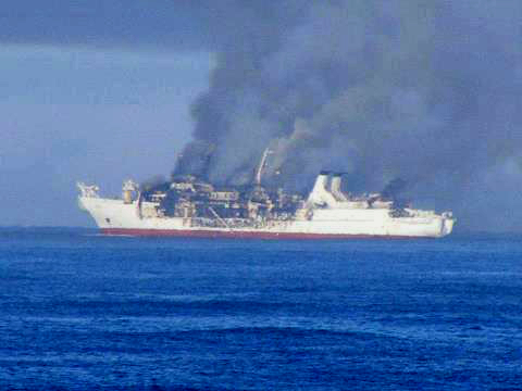
| Chamarel | 2012 | Mauritian cable layer ; Schiff was left to its own devices after a fire broke out on August 9, 2012; dropped a day later; later pulled ashore and scrapped | photo | |
| Dunedin Star | November 29, 1942 | The reefer ship ran aground 80 km south of the Kunene on the Skeleton Coast . |
18 ° 08′00 ″ S 011 ° 33′00 ″ E |
.jpg)
|
| Eduard Bohlen | September 5, 1909 | The freighter ran aground on September 5, 1909 south of Conception Bay. |
23 ° 59'45.3 "S 014 ° 27'27" E |
 more photos |
| Erycina | 4th September 1896 | Norwegian barque for loading guano , which leaked in early September 1896; later abandoned and washed ashore; today probably completely destroyed | ||
| Frotamerica | February 15, 2013 | The cargo ship ran aground on February 15, 2013, 33 km north of Lüderitz . |
26 ° 22'12 "S 015 ° 02'24" E |
 more photos |
| Fukuseki Maru No. 7th | March 22, 2018 | Japanese trawler that ran aground in heavy seas not far north of mile 108, about 1.5 km offshore; any attempt at recovery failed |
-21.436075 13.810246 |
photo |
| Maridal | 1926 | ran aground off Possesion Island | ||
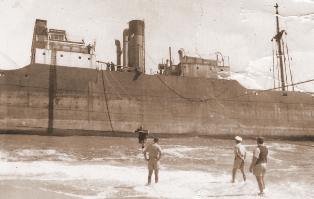
| Gertrud Woermann II | November 20, 1904 | Loaded with provisions, soldiers, and horses, and ran into land in the fog; visible until 1912; today a beacon reminds of the place |
_bei_der_Ausreise_von_Hamburg_nach_Deutsch-S%C3%BCdwestafrika,_1904.jpg) photo |
|
| Gethen | January 26, 1954 | Trawler that ran aground off the north dune at Henties Bay ; today the engine block may still be visible at low tide | ||
| Henrietta Spasheti | July 14, 1968 | The trawler ran aground in July 1968 165 nautical miles north of Walvis Bay at Koigabmond; visible today on the southern edge of Torra Bay . |
20 ° 27'28 "S 013 ° 15'01" E |
Photo photo |
| Montrose | 1973 | Also ran aground on the southern edge of Torra Bay in 1973 | photo | |
| Natal Coast | 1955 | In 1955 the steamer ran aground on a sandbank 18 km north of Swakopmund in fog. The crew was uninjured and was able to leave the ship after the coast guard arrived. | photo | |
| Otavi | 1945 | The steamer ran aground in 1945, 105 km north of Lüderitz in Spencer Bay . |
25 ° 43'56 "S 014 ° 50'00" E |
 more photos |
| Resplendent | February 18, 2020 | The Hangana trawler flooded and sank quickly; 26 sailors rescued, captain missing and search stopped. Wreck lies at a depth of 318 meters. |
21 ° 51'40.2 "S 12 ° 51'35.2" E |
|
| Shaunee (Shawnee) | 1976 | Trawler coming ashore at Conception Bay |
23 ° 40'23.1 "S 14 ° 30'12.9" E |
.jpg)
|
| Sir Charles Elliot | December 3, 1942 | South African tug that ran ashore in 1942; he was previously on duty to rescue the Dunedin Star | ||
| Suiderkus | December 1976 | Modern trawler that ran aground on its maiden voyage not far from Möwe Bay ; can still be seen today in large parts | Approximately 19 ° 22'S 012 ° 42'E |
photo |
| SW Seal | Wreck seen north of Torray Bay | |||
| Vipava | 7th July 1968 | In thick fog, this Iranian freighter ran aground 16 miles north of Swakopmund; a summoned tug could not get the ship free; the ship was then abandoned, which led to a total loss | ||
| Winston | 1970 | The East German trawler ran aground two miles south of the Ugab estuary in thick fog ; Well preserved for years, it broke; still partly clearly visible today | ||
| Zeila | August 25, 2008 | The trawler ran aground on August 25, 2008, 14 km south of Henties Bay . |
22 ° 14'28 "S 014 ° 21'13" E |

|
| unknown | 18xx | American whaling ship in Omaruru estuary; Parts of it were later used to build the first houses in Henties Bay | ||
| unknown | Unidentified wreck on the west coast of the Walvis Bay lagoon |
22 ° 54'25 "S 014 ° 26'11" E |

|
Individual evidence
- ↑ a b Metje + Ziegler History. Official website of Metje + Ziegler. Retrieved April 2, 2020.
- ↑ Roff SMITH: Diamond Shipwreck . In: National Geographic . October 2009.
- ^ Namib, Secrets of a desert uncovered , Mary Seely and John Pallett, Venture Publications, Windhoek Namibia. ISBN 978-0869767818
- ↑ a b c d e f g h i j Shipwrecks. Henties Bay Tourism. Retrieved March 8, 2018.
- ^ Chamarel project ”. Kraatz Marine. Retrieved March 8, 2018.
- ↑ See English Wikipedia page MV Dunedin Star
- ↑ Amy Schoeman: Skeleton Coast . Struik, 2003, ISBN 1-86872-891-9 , p. 98.
- ↑ See English page Conception Bay (Namibia)
- ^ Skeleton Coast, Swakopmund & Walvis Bay . Brian McMorrow (PBase). Retrieved March 22, 2013.
- ↑ Ship Descriptions - E . The Ships List. Archived from the original on February 4, 2012. Retrieved March 22, 2013.
- ↑ Wreck Frotamerica
- ↑ Press release: Ghost ship in front of Lüderitz Bay
- ↑ "Fukuseki" just junk ?. Allgemeine Zeitung, April 5, 2018.
- ↑ See geoview.info
- ↑ map
- ↑ Hake trawler sinks off coast ... skipper missing. New Era, February 19, 2020.
- ↑ Search for missing skipper called off. Informanté, February 19, 2020.
- ↑ Press Release, No. 394. Ohlthaver & List / Hangana Seafood, March 4, 2020.
- ↑ Namibian Shipwrecks. Ultimate safaris. Retrieved March 8, 2018.
- ↑ Shipwrecks at Skeleton Coast. I Dream Africa. Retrieved March 9, 2018.
- ^ The Shipwrecks of the Skeleton Coast of Namibia. Discover Namibia. Retrieved March 8, 2018.
- ^ Three Shipwrecks on Namibia's Skeleton Coast. Namibia Tourism Board. Retrieved March 8, 2018.
- ↑ Wreck Winston on Namibia's coast disappears gradually presented in the Namibiana book depot. Retrieved February 25, 2019 .
- ↑ Wreck Zeila