
Littenbach (Rhine Valley Inland Canal)
|
Littenbach Fallbach |
||
 |
||
| Data | ||
| Water code | CH : 2139.0 | |
| location | Canton of St. Gallen ; Switzerland | |
| River system | Rhine | |
| Drain over | Rhine Valley Inner Canal → Old Rhine → Lake Constance → Rhine → North Sea | |
| source | Bensol ( Oberegg ) 47 ° 25 ′ 14 ″ N , 9 ° 31 ′ 34 ″ E |
|
| Source height | 1060 m above sea level M. | |
| muzzle |
Rheintaler Binnenkanal coordinates: 47 ° 26 '18 " N , 9 ° 38' 33" E ; CH1903: 766 222 / 256498 47 ° 26 '18 " N , 9 ° 38' 33" O |
|
| Mouth height | 404 m above sea level M. | |
| Height difference | 656 m | |
| Bottom slope | 73 ‰ | |
| length | 9 km | |
| Left tributaries | Blaubach, Kübach | |
| Right tributaries | Ächeli (Husen) | |
| Communities | Berneck , Au | |
| Navigable | No | |
| Forms an 8 m high waterfall. | ||
The Littenbach is a river in the St. Gallen Rhine Valley in the eastern Swiss canton of St. Gallen . It drains part of the northeastern foothills of the Appenzell Pre-Alps and feeds their waters to the Rhine Valley inland canal .
geography
course
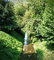
The Fallbach rises above Oberegg at an altitude of 1060 m. ü. M. At the confluence of the Sulzbächli with the Fallbach it is named Littenbach . It then forms an 8 m high waterfall before flowing through the Taatobel towards Berneck.
The lower course of the Littenbach was greatly corrected as part of the amelioration of the Rhine plain .
Littenbach river system


- Littenbach
- Fallbach ( right source stream ) 4.5 km (with Schneietenbach 6.4 km), southeast of Sulzbach
- Schneietenbach ( left source stream ) 1.8 km, west of Oberegg
- Eugstbach ( right source stream ) 1.8 km, west of Oberegg
- Moosbach ( right ) 1.3 km, south of Oberegg
- Blaubach ( left ) 1.8 km, north of Reute
- Schitterbach ( left ) 0.6 km, east of Oberegg
- Städelibach ( left ) 0.3 km, east of Oberegg
- Schitterbach ( left ) 0.6 km, east of Oberegg
- Oberrütibach ( right ) 0.9 km, east of Reute
- Litenbach ( right ) 0.3 km, south of Reute
- Sulzbächli ( left source stream ) 1.5 km, southeast of Sulzbach
- Mülibach ( left junction ) 1.3 km, in Berneck
- Mülibach ( reflux )
-
Kübach ( Schlifibach ) ( left ) 3.3 km, northeast of Berneck
- Hasetbach ( left ) 0.7 km, Unterfeld
- Kobelbach ( left ) 1.3 km, southeast of Kobel
- Täschenleererbach ( left ) 0.4 km, Kobel
- Haslachbach ( left ) 0.4 km, Au
- Fallbach ( right source stream ) 4.5 km (with Schneietenbach 6.4 km), southeast of Sulzbach
Localities
environment
The Littenbach was significantly corrected at its lower reaches, and the course of the river was artificially changed in order to gain more cultivated land in the Riet . In order to reduce the dangers of floating debris and debris during floods , debris collectors were built in front of the castle bridge and in the Schossenriet area, a debris barrier with debris collector .
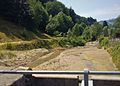
Flood collectors in Berneck seen from the castle bridge
Flood collector in the Schossenriet area

The Littenbach between Berneck and Au (looking towards Berneck)

Confluence of the Kübach (from above) into the Littenbach (from the left)
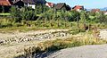
The Littenbach in Au before the confluence with the Rheintaler inland canal

The confluence of the Littenbach in the Rheintaler inland canal in Au


