Los Millares

Los Millares is a Copper Age settlement in Andalusia . It is located on an elevation about 25 kilometers north of Almería at the confluence of the Rambla de Huechar with the Rio Andarax between the municipalities of Santa Fé de Mondújar and Gádor in southeastern Spain . Los Millares consists of a walled settlement and a collection of passage graves . She gave her name to the Los Millares culture , which had a significant influence on the cultures of Spain and Portugal. Los Millares is the place with the largest dome grave necropolis known to date (over 100 structures) and thus the only place where the settlement and burial place are known to be equally well known.
The culture of the 3rd and early 2nd millennium BC Chr. Grew wine and olives and left behind a ceramic decorated with symbols , which was primarily found in megalithic systems and dome graves (according to Leisner differentiated into phases I + II). The settlement was from around 3200 BC. BC to 2250 BC Inhabited. According to archaeologists, not only the Rio Andarax carried more water at this time, but also the Rambla de Huechar. The climate at that time is said to have enabled almost tropical vegetation.
The walled area
The settlement covers an area of about five hectares. In contrast to Neolithic settlements, it is enclosed by three concentric stone walls, of which the outer, about two meters thick, mighty stone wall, which has semicircular bastions and a monumental entrance gate at irregular intervals . It includes a necropolis and a settlement area. A second stone wall with an entrance gate within the area bounded by the outer wall separates the settlement from the necropolis. Within the territory bounded by the second wall, a third, the innermost wall, divides the area at the end of the ridge, which is interpreted as a manor's residence, from the residential and craft area. However, this third wall was destroyed again during the settlement phase. According to radiocarbon dating , the outermost wall is said to be 3025 BC. BC collapsed and then rebuilt stronger.
Outside the outermost wall there are around thirteen different sized fortifications, which are interpreted as defensive structures. They are positioned on smaller elevations in the area. Some of these fortifications, like the settlement itself, have cisterns .
The settlement, which has not yet been investigated, contains the foundations of round huts with a diameter of about 6 meters, which mostly lean against the wall. Evidence of copper smelting was found inside the rectangular building . This is why Los Millares is seen as important in understanding the transition from the Neolithic to the Bronze Age . Four round stone buildings lie on a ridge at a distance of about 0.8 kilometers. The largest is about 30 meters in diameter, consists of double concentric stone walls connected to one another and also has bastions on the outside that did not have a fortification function.
In the west there are around 80 dome graves in round piles of stones with a mean diameter of 15 meters. Some are fully megalithic, others have megalithic walls and cantilever vaults as drywall . The chambers, which are always round, sometimes have side chambers made of dry stone. The short, low corridors are often divided into corridor and antechamber. Some chambers are lined with plates and painted. From some of the corridors there are niches that may be used for funeral purposes e.g. B. served by children. The inconsistent orientation (e.g. east or south) of the graves seems to adapt to the topography . The archaeologists assume that each dome grave was reserved for a tribe or a clan.
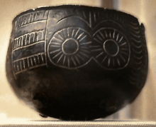
Rich finds were made in the buildings: ceramics of the Almería type, however with conical (not bulbous) vessels, richly decorated goods, especially symbolic ceramics (double spirals or oculi eye idols ), the motifs of which are also on various idols made of stone, clay and bone appear, as well as copper tools and objects made of African ivory and ostrich eggshells that indicate trade contacts with Africa.
Most descriptions assume around 1,000 to 1,500 residents; in the detailed current documentation on site, the researchers speak of around 5,000 residents. Because of the various findings, they assume a division of labor , hierarchy of structured society. Los Millares is seen as part of the megalithic and bell beaker culture . Similarities between the architecture of Los Millares and that of Monte d'Accoddi in Sardinia have been recorded. At the same time as Los Millares there were other settlements in the area in Almizaraque (Bajo Almanzora), Terrera Ventura ( Tabernas ), El Tarajal (Campo de Níjar), El Malagón, Las Angosturas, Cerro de la Virgen, Cabezo del Plomo ( Mazarrón ) , Les Moreres ( Crevillente ) etc. At the same time there were significant settlements in Los Silillos and Cabrera. The successor was the El Argar culture , for which the Vila Nova de São Pedro site in Portugal stands.
Discovery story
The settlement was discovered in 1891 during the construction of the railway through the valley of the Rio Andarax. The Belgian Luis Siret carried out the first excavation. Further excavations followed. Today the railway runs in a tunnel below the ridge of the hill.
literature
- M. Carrilero Millán and A. Suárez Marques: El territorio almeriense en la prehistoria. Almería 1997, ISBN 84-8108-134-5
See also
Web links
Coordinates: 36 ° 57 '52.8 " N , 2 ° 31' 21.3" W.


