
Lucas Janszoon Waghenaer

Lucas Janszoon Waghenaer also Wagenaer, (* 1533 / 34 in Enkhuizen ; † 1605 / 06 ) was a Dutch Navigator and Kartograf .
Life
During Waghenaer's lifetime, Enkhuizen rose from a fishing village (with a focus on trade with the Baltic States and herring fishing) and part of the Spanish Netherlands to one of the most important ports in the independent Netherlands. Between 1550 and 1579 Waghenaer sailed the seas as a ship's officer (navigator, helmsman). During these years he had contact with Spanish, Portuguese and Italian sailors who influenced his later work on nautical charts . He later worked in the port of Enkhuizen, where he collected fees from berthing ships. He apparently died impoverished as the town extended his widow's pension for a year after Waghenaer's death.
In 1577 his map of Enkhuizen appeared, his first published map. In 1584 (dating 1583) and 1585, his Spiegel der Seefahrt appeared in Dutch in two parts, a collection of nautical charts (Atlantic coast from Norway to Portugal, England, the Baltic Sea with Denmark and the German Baltic Sea coast) with instructions on navigation and related tables. The book was the first collection of its kind, was widely distributed and was translated into Latin in 1586, into English in 1588 (as The Marriners Mirrour and where such map collections became known as Wagoner), translated into German by Richard Slotboom in 1589 and into French in 1590, this also added his own information on the Baltic coast in Mecklenburg. The printing was done by Christoffel Plantijn in his printing house in Leiden, the engravings of the cards were done by Joannes van Doetecum, who was a leader in this field at the time. Waghenaer initially bore the costs, which was well beyond his financial circumstances, so in the foreword of the second part he thanks the mayor of Enkhuizen Francois Maelsen, who is his friend, for his support.
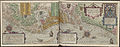
In his maps in the mirror of seafaring he also indicated water depths and he also used symbols for the first time, for example for anchorages and dangers under water, landmarks and coastal profiles. The cards, engraved by Baptist and Johannes van Deutecom, were of outstanding quality. The maps also included an overall map of Europe including parts of North Africa to the Canaries and Iceland, the first such printed map. This novel compilation of navigation instructions with nautical charts became known as Waggoner . In 1589, Cornelis Claesz acquired. in Amsterdam the publication rights and there were updated reprints from 1589 to 1605 there and in Antwerp with Jean Bellère. In the Latin edition of 1592 a significantly improved and expanded map of Europe by Baptista von Doetecom appeared. The edition of Der Spiegel from 1603 also contained parts (coastal profiles and text) from Waghenaer's now published Safe of Seafaring and new maps by Benjamin Wright (three double-sided and twelve smaller ones).
In 1592 his seafaring safe ( Thresoor der zeevaert ) was published by Francois van Raphelenghien in Leiden (the head of the Plantijn branch there) and in 1598 his Enkhuizer sea chart book ( Enchuyser zeecaertboeck ). Waghenaer had come to the conclusion that his Spiegel der Seefahrt was too large for seafarers with the folio format used and that the descriptions were not detailed enough. In addition, he had meanwhile gathered a lot of new information from Dutch seafarers from other sea areas that were not dealt with in the Spiegel. The safe consisted of three parts. In the first part a much more precise guide to navigation was given than in the mirror. The second part consists of 20 large coastal maps (approximately in the format 1: 600,000) and 166 pages of navigation instructions in 21 sections for western, northern and eastern navigation. Many of the maps and coast profiles were from Joannes van Doetecom. For the first time in a Dutch publication there were sailing instructions around Scotland and the Hebrides and the White Sea . The third part contained sailing instructions for the western Mediterranean (without maps) and was the oldest book with such navigation instructions (although Willem Barents had published a map atlas for these sea areas in 1595). The instructions were more detailed than in the mirror and it also entered sight lines for important landmarks (as in Amstelredamsche zee-caerten by Aelbert Haeyen 1585). Only Dutch and French editions were published, first by Plantijn in Leiden, but in the following editions all by Cornelis Claesz. in Amsterdam. By 1601 the printing plates had become so bad that Cornelis Claesz. had new ones made. In 1602 a Dutch edition appeared with sailing instructions and coastal profiles of the East and West Indies, corresponding to the first efforts of the Dutch to enter the Portuguese spice trade in the east and the Spanish trade with the Caribbean. The last edition appeared in the year Cornelis Claesz died. 1609. Willem Jansz. In 1608 Blaeu published a similar book based on the model of Waghenaer ( light of the zee-vaert ). The Enkhuizer Nautical Chart Book from 1598 is the rarest of the works by Waghenaer, was in the smaller octave format and was for seafarers who could not afford the more expensive works by Waghenaer and who still preferred the tradition of the older nautical books, the form of which Waghenaer described in the book returned (it only contains two maps, one of the Zuiderzee and one of Enkhuizen). It contains 346 pages of instructions for western and eastern navigation with many woodcuts of coastal profiles. It also includes sailing instructions for West Africa and Brazil. A second edition appeared in 1601 and a third in 1605.
The circle in which he frequented Enkhuizen at that time included Dirck Gerritz Pomp , Jan Huygen van Linschoten and Bernardus Paludanus .
Further illustrations of his nautical charts
Coast from Emden to Flanders

Bay of Biscay

Dutch-Flanders coast between The Hague and Bruges

Thames estuary


Publications
- T'eerste deel vande Spieghel der zeevaerdt, van de navigatie der Westersche zee, innehoudende alle de custen van Vranckrijck, Spaingen ende 't principaelste deel van Engelandt, in diversche zee caerten berepen . Christoffel Plantijn, Leiden 1584. Digitized . A facsimile edition was published in the Theatrum Orbis Terrarum series, Amsterdam 1964 (Commentary by RA Skelton)
- The ... part of the mirror of seafaring: from navigation of the Occidentisches Meer, or the western lakes (... vd Noerdschen and Orientischen Schiffahrt) . - Amsterdam: Claesz, 1589. Digitized edition of the University and State Library Düsseldorf ; Volumes 1 and 2
- Thresoor der zeevaert, inhoudende de geheele navigatie ende schip-vaert vande Oostersche, Noordtsche, Westersche ende Middellantsche Zee, Amsterdam: Claesz 1596, digitized , facsimile in the Theatrum Orbis Terrarum series, Amsterdam 1965
literature
- Julius Lowenberg : Waghenaer, Lucas Jan . In: Allgemeine Deutsche Biographie (ADB). Volume 40, Duncker & Humblot, Leipzig 1896, p. 483.
- RD Baart de la Faille: Nieuwe Gegevens over Lucas Jansz. Wagenaer , Het Boek, Volume 20, 1931, pp. 145-160
- Cornelis Koeman: Lucas Janszoon Waghenaer: A sixteenth century marine cartographer , The Geographical Journal, Volume 131, 1965, pp. 202-212, JSTOR
- Cornelis Koeman (Ed.): The history of Lucas Janszoon Waghenaer and his Spieghel der Zeevaerdt , Amsterdam, Lausanne: Elsevier-Sequoia 1964 (with facsimile)
- Désiré Gernez: Lucas Janszoon Wagenaer: A chapter in the history of guide-books for seamen , Marriner`s Mirror, Volume 23, 1937, pp. 190–197, and The works of Lucas Janszoon Wagenaer , ibid., Pp. 332– 350
- Robert Putman: Nederlandse Zeekaarten uit de Gouden Eeuw , Abcoude: Uniepers, 2005
- Robert Putnam: Early Sea Charts , Abbeville Press 1983
- Franz Gittenberger, Helmut Weiss: Zeeland in oude Kaarten , Lannoo, Tielt, 1983
- Lucas Jansz. Waghenaer van Enckhuysen. De maritieme cartografie in de Nederlanden in de zestiende en het begin van de zeventiende eeuw , Vereniging Vrienden van het Zuiderzeemuseum: Enkhuizen, 1984
- J. Bossu: Vlaanderen in oude kaarten: three eeuwen cartography . Lannoo: Tielt 1983
Web links
- Literature by and about Lucas Janszoon Waghenaer in the catalog of the German National Library
- Lucas Janszoon Waghenaer (1533-1606), Historische Kaarten Kustzone
- DBNL
Individual evidence
- ↑ 22 maps of the western navigation between Texel and Cadiz in the first volume (next to the map of Europe), 22 of the northern navigation between Zuidersee and Norway and Finland in the second volume. The individual maps each have a scale of around 1: 400,000, with four pages each, one with navigation instructions, two with the map and there is a blank page for the user to take notes.
- ↑ In Part 1, 33 pages are devoted to navigational science and nautical astronomy, including tables for determining the tide at new moon, tables and explanations for the declination of the sun and stars, explanations on the use of a Portolan map and the cross staff , tide tables, water depths and information about Sandbanks in different parts of the North Sea, distances between important ports.
- ↑ The translation was done by Anthony Ashley, the engravings were by Theodor de Bry, Jodocus Hondius , Augustine Ryther. Hondius was in London until 1593 and published another edition on his return to Amsterdam in 1605, as he was in possession of the copper plates for the map engravings.
- ↑ Such profiles were already used by João de Castro in his sea book for the Red Sea in 1541, but were systematically used for the first time by Waghenaer
- ↑ Günter Schilder, Marco van Egmond: Maritime cartography in the low countries during the renaissance, in David Howard (ed.), The History of Cartography, Volume 3 (Cartography in the European Renaissance), University of Chicago Press 2007, p. 1385
- ↑ Claesz. is the common name abbreviation for Claeszoon in Dutch
- ↑ There is also an overview of older literature on navigation instructions and their errors
- ↑ The book was also very successful and in terms of coastal navigation was more detailed than Waghenaer, but only dealt with the North Sea. Haeyen was a helmsman from Haarlem. The book was also published by Plantijn in Leiden.
| personal data | |
|---|---|
| SURNAME | Waghenaer, Lucas Janszoon |
| ALTERNATIVE NAMES | Wagenaer, Lucas Janszoon |
| BRIEF DESCRIPTION | Dutch navigator, helmsman and cartographer |
| DATE OF BIRTH | 1533 or 1534 |
| PLACE OF BIRTH | Enkhuizen |
| DATE OF DEATH | 1605 or 1606 |
| Place of death | Enkhuizen |