Lurngau
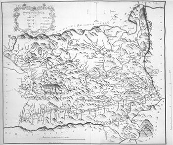
The Lurngau (also: Grafschaft Lurn ) was one of the medieval districts that practically comprised all of Upper Carinthia and East Tyrol . The county of Lurn is mentioned for the first time in 974 in a donation from Otto II for the diocese of Freising .
Geographical location
Its center was the Lurnfeld , followed by the Mölltal to the northwest , the upper Drautal to the west until just above the current district capital of Lienz and then the Isel valley with the side valleys. Down the river Lurngau reached as far as Villach ; the Gail valley was one of them.
To the west of Lienz, the Lurngau bordered the Gau Pustertal , in the east the Lurngau met the Kroatengau and the County of Friesach .
The Drau formed the boundary of the church's spheres of influence: north of the Drau the Archdiocese of Salzburg was responsible, south of the Drau the Patriarchate of Aquileia .
The original center of the Lurngau was the Hohenburg as the seat of the Counts of Lurn .
Counts in Lurngau
- Ottwin († 1019), ∞ Wichburg (Lurngau)
- Engelbert IV. († 1040)
Counts of Lurn (until 1135)
-
Udalschalk († 1115) from the Ernste von Grögling-Hirschberg family
- Konrad († 1112), Count im Lurngau, Vogt of Aquileia
- Altmann von Lurngau († 1149), Bishop of Trient , second founder of Suben Abbey , bequeathed Hohenburg to Salzburg in 1142
- Adalbero († 1135), Count in Lurngau
From 1135, after the extinction of Lurner counts, the Archdiocese of Salzburg had the places Pusarnitz , Sachsenburg , Gmund and Stall im Mölltal , later Gorizia Meinhardiner began in the area around Lienz towards Friuli develop and Spittal down The county of Ortenburg was able to become independent from 1135 , the area of which had also belonged to the Lurngau until then.
See also
- List of medieval districts (with map)
