Lusthaus (Cologne)
The Lusthaus was a mansion in the Rath / Heumar district of Cologne on the right bank of the Rhine .
location
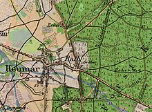
The small complex in the form of a pleasure palace was located about 400 meters north of Rath Castle , about 150 meters to the right of the Rather Kirchweg , which connected it with the Catholic parish church of St. Gereon in Merheim (on the map north of Heumar, on the right of the number 50 , above cap ). The Lehmbacher Weg branches off just 100 meters further . One of the numerous watercourses that came from the Königsforst through the fields fed the former ditches of the complex from the direction of the Erker-Mühle. The area, which is still comprehensible in the locality, covers around three hectares .
At the time of its probable use, the view from the facility to Cologne and the cathedral there was still unobstructed, so that its purpose can be seen here and in the type of facility.
History and remains
Little is known about the history of the pleasure house. In the mid-1920s, Bendel mentions the remains of the moat and a tower that can still be found. The Lusthaus already recorded the map of the Duchy of Berg by CF Wiebeking from 1790, but without a name. On the topographic map published in 1893 as part of the Prussian New Admission, the complex is shown with several parts of the building and associated gardens.
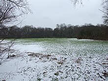
The location of the "Lusthaus" is not directly visible and is now dense with trees. It is part of the "Am Lusthaus" biotope, which is designated as a protected landscape component (LB 8.07). The space in between to Rather Kirchweg is still unused or pasture land.
At the beginning of the Rather Kirchweg (behind house number 16) a new building area with 31 single-family houses will be built from the end of 2013. At the 36th meeting of the Kalk district council on November 28, 2013, it was decided to name the new plan street after the subsequent hall name - Am Lusthaus.
literature
- Johann Bendel : Homeland book of the district of Mülheim am Rhein. History and description. Sagas and stories. 3. Edition. Self-published, Cologne-Mülheim 1925, p. 434.
Individual evidence
- ↑ Jürgen Huck : Castle Röttgen and Durchhausen in Heumar (= Our Porz. Contributions to the history of the office and town of Porz . Issue 16) Heimatverein Porz eV in connection with the Porz town archive, Porz 1974, table 4.
- ↑ Development plans for the city of Cologne - Am Lusthaus in Rath / Heumar
- ^ Council information city of Cologne - TOP 8.1.1: Designation of a plan street in Cologne-Rath / Heumar
Coordinates: 50 ° 55 ′ 44.4 " N , 7 ° 4 ′ 55.5" E


