
Stüttgenhof
The Stüttgenhof is one of the oldest courtyards in Cologne and has been a listed building since 1989 . It is also one of the few large Cologne manors that have been preserved in parts of their old building structure and form of investment, on which the owners still farm themselves .

Location and environment
The farm is located in the Junkersdorf area, on the west side of the Stüttgenweg, named after him, that runs between Dürener and Gleueler Straße. This limits the area of the Cologne-Lindenthal district and the outer green belt of the city to the west.
In the vicinity of the farm runs the Frechener Bach , which already fed the medieval moat and ponds for the farm's fish farming via a feed line and whose water is still used when required. The course of the brook, whose formerly abundant amounts of water still supplied the pond of the nearby Cologne city forest , newly created by Adolf Kowallek at the end of the 19th century , never reached the Rhine . It was renatured as part of the Regionale 2010 project . This project also creates an extension of the outer green belt near the courtyard (behind the KVB railway line ), the plants of which will encompass a new forest of 40,000 m² through the planting of around 17,000 young trees of different species. This is being done on an area previously used for agriculture that was formerly part of the old Krieler Hofgüter, such as the Stüttgenhof.
history

Early traces of settlement
The history of the development of the courtyard, which is partly still surrounded by a moat, goes back a long way. The courtyard, first mentioned in a document in 1271, is located in an area where archaeological research has shown a settlement history that goes back to the Neolithic .
Settlement place of the band ceramic culture
The systematic archaeological and topographical explorations of the urban area, begun by Fritz Fremersdorf in the 1920s and 30s, succeeded with the uncovering of the "Lindenthaler Dorf", a Stone Age settlement excavated in 1929 on the area between the Stüttgenweg and the military ring road , a sensational success for the Cologne residents Soil monument maintenance. The results of the investigation prompted the prehistorian Buttler and the archaeologist Haberey to assign the discovered settlement to the ceramic period.

Settlement place of the Hunsrück-Eifel culture
In 1973, the Romano-Germanic Museum, in its capacity as the Office for Archaeological Soil Conservation of the Cologne city area, learned that the land of the Stüttgenhof had been transferred to Rheinbraun AG, which was planning to build a complex administrative building on the acquired site.
The morphological conditions of the site documented in the 1930s and the immediate vicinity of the early Neolithic excavation field of the "Lindenthaler Dorf" prompted the office to carry out new soil investigations, during which numerous finds were uncovered and recovered. The knowledge gained south of Dürener Straße and northeast of the Stüttgenhof through cut excavations confirmed a continuation of the early Neolithic culture of the pre-war excavation area, only 300 meters away . The finds now occupied a settlement area that the archaeologists assigned to the Hunsrück - Eifel culture, a regional Iron Age cultural group of the Middle Rhine region that dates back to around the end of the 7th century BC. Until around 250 BC Lasted.
Roman settlement
This period was soon followed by the Romans, whose “granary” became the western foreland of their Colonia. They too left numerous traces, as evidenced by many finds in this area. They created large estates and operated extensive agriculture , as was later continued by the owners of the "Villa Stute" and the following owners of the Stüttgenhof until the advent of artificial fertilization.
Name interpretation
The oldest documents of the Stüttgen farm designate him with the name "zum Stuytgen" but also "zom Stuitgin", a form of the name that was common in the Ripuarian language area. Herzuleiten are the names of Germanic origin, the Anglo-Saxon and Low German word "stôd", as well as the Middle High German "stuod", which denote horses pferch in these variants .
The connection between such a farm name can be seen in the herds of wild and semi-wild horses that existed in the area on the left bank of the Rhine during the Franconian period up to the early Middle Ages, and the farms that caught the horses and penned them in order to slowly domesticate them .
From a manor to a private estate
The “Villa Stute”, owned by the Teutonic Order Coming St. Katharina in Cologne (later Coming Boys-Biesen ) in 1271 , gave its name to today's Stüttgenhof estate and the street named after it, Stüttgenweg.
In 1336 the estate was then owned by the Jude patrician and mayor family of Cologne . At that time, Ritter Göbel Jude and his wife Elisabeth Hardefust bequeathed the Stüttgenhof property to their daughter Imagenia, who brought it as a bridal gift from her parents to the marriage with “Johann von Spiegel zum Irgang”. The ownership of the estate changed several times in the period that followed until it was again owned by the von Hardefust family. The lands were sold, however, with a part going into the possession of the Brauweiler Abbey (which kept it until the secularization under French rule ) and the other part with court was acquired by the Knights of Fischenich .
- Gentlemen at Gut Stüttgen

Medieval coat of arms of the Teutonic Order

Coat of arms of the Knights of Fischenich

Adam Ploog family

Family of sea


Daem von Fischenich kept the farm in operation until the 15th century, but was forced to sell it in 1485 for financial reasons. The new owner of the property was now the St. Gereon Abbey in Cologne , under which the property was awarded as a proper knight's fief . For this time, the Stüttgen farm belonging to the monastery was given as three manses .
Rights of use of the Gereonstift

The Stüttgenhof had been equipped with bodies of water since earlier times, which was ensured by a supply line from a stream flowing down from Frechen and which brought a variety of benefits. This included the drinking water supply for humans and cattle and the feeding of the weir ditch. Furthermore, ponds had been created that were used for fish farming, but later also for the spa treatment of ecclesiastical gentlemen who had come to the St. Gereon Abbey. This right of use on Stüttgen, which is specifically mentioned here, was apparently retained by the monastery until the secularization, because it was mentioned in the documents in 1761, in which the canon of the monastery and later canon, Hermann Werner von Bossart , is named, to whom the rights to the "Tusculanum Stüttgen ”were granted.
Tusculanum Stüttgen

As early as the 16th century, but at the latest after the resolutions of the Council of Trent (1545–1563), internal church details were regulated, including, for example, the right to leave for individuals within the clergy . The human achievement, which meant the granting of annual leave of six weeks in total, spread only slowly and only began to gain acceptance in the 17th century. It was then also introduced at Cologne monasteries and later became normal. At St. Gereon it was decided in 1628 to emulate the example of other monasteries and, following the suggestions of the Tridentine, began to give their own clergy this holiday season.
Initially, the clergymen of the Cologne archbishopric in question traveled to spa cures in places that were relatively close to them, such as Aachen , Ems , Spa , Schwalbach or St. Tönnis. Later they thought about the possibility of their own land, which was prepared accordingly and subsequently used like on Stüttgen. It was called Tusculanum.
Parish of Kriel

At least since the takeover of the farm by the St. Gereon monastery, it was like the hamlets of Kriel, Lind and the courts there such as the Hofgut Kitschburg, the Hof Kriel and the Platzhof, the Decksteiner and Palanterhof, the Hohenlind and the Mönchshof and the Kleijohanshof belongs to the parish of Kriel.
For the people living on the Stüttgenhof, this meant that the church service could be reached by walking a few kilometers to the Krieler Dom parish church . The same applied to baptisms , weddings and funerals , which initially took place in the Krieler Kirchhof . There are still remarkably well-preserved tombstones from the 16th to 18th centuries, which also include specimens that were erected for the deceased of the Stüttgenhof. Their final resting place was the municipal cemetery on Decksteiner Strasse, which opened in 1869 and was occupied until 1917 and is now used as a park .
From the year 1688 the Stüttgenhof was given to the middle class by the monastery and for the year 1761 the entries of the Gereonstift report of burning farmhouses in Stüttgen. The rear barn wall of the Vierkanthof (the transverse building oriented towards Marsdorf) gives cause for corresponding conclusions , it clearly shows a line between the very old and the more recent masonry rising on it (see Commons). In 1802 the Stüttgen estate was also confiscated by the French as a spiritual endowment . At that time, Hof and the lands largely east of the Stüttgenweg covered an area of 95.2 hectares .

Memorial plaque to the couple Ploog / Krosch, Krieler Dom churchyard

Grave steles of the Ploog family

Entrance to the old Decksteiner cemetery

Friedrich Ploog, Decksteiner Strasse cemetery


Hofgut Stüttgen in private ownership
At first the estate was managed by a tenant named Mathias Otten, until it passed from the French to the Prussian state. Adam Ploog, originally from Flittard , won the auction of state estates in 1821 and, with the acquisition of the Stüttgen estate, became the founder of a family business that still exists today.
Adam Ploog, who probably had experience in the management of an agricultural business as the leaseholder of the Barons von Fürstenberg , the branch of the Rhenish family, died in 1849 at Hof Stüttgen, on which there is still an inscription on a grave slab. However, the line of succession at this time is unclear. Hilger Ploog, who was also born in Flittard, says on the tombstone at Krieler Dom "the honorable gentleman ......, pensioner of single class (1812 - 1860) died at the Stüttgerhofe". Another grave stone of the family, now in the Decksteiner Friedhof, gives the life dates of Friedrich Ploog with 1860 to 1890. In the literature on the Stüttgenhof it is stated that the farm was leased at the end of the 19th century.
Changes at the turn of the century

The incorporation of the areas of the mayor's offices of Efferen and Müngersdorf into the city of Cologne in 1888 changed the everyday life of the residents of the previous rural community of Kriel only insignificantly. The building boom that began in the middle of the 19th century prompted many farmers to sell their land in the urban area. The sold parcels with their rich clay soils were exploited for the production of bricks and thus later became a site that could only be used as building land. The areas of the courtyards on the periphery of the emerging suburbs remained untouched by this. The Hofgut Kriel, the Platzhof, and a homestead belonging to the Kitschburg, as well as the Stüttgenhof, which is still in use today, kept up until the 1980s / 90s.
Probably after the lease agreements had expired, the “von Meer” family, probably descendants of the Ploog family through marriage, took over the management of the estate as owners.
Known construction work
The history of the property, which is quite well documented with regard to the frequent changes in ownership, hardly reveals any data regarding structural changes. The sprightly senior of the von Meer family, born in 1920, stated that the property acquired by Adam Ploog was still completely surrounded by a moat. He also stated that the foundation area of the south-eastern front building, made of field fire bricks , was very old due to its porous condition and probably belonged to a construction phase of the 18th century. The base walls of the western farm building are also said to be of older origin, the parts of which were built to raise the roof stand out clearly from the original masonry. Other parts of the structure were rebuilt or rebuilt in 1890 and from 1930. The brick house on Stüttgenweg, which is now a monument, was probably built between these years; it is about 50 meters south of the courtyard and probably served as a servants' house .

Preserved moat on the northeast side

Front building with the oldest building structure

Roof structure of the oldest farm building
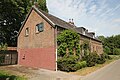
Former servants' house


The residents received their drinking water from a well made of masonry bricks that was driven 14 to 16 meters into the earth. The shaft in front of the manor house, from which the water was last pumped with a hand pump, has been closed since the post-war period .
Today's courtyard
Even after the land was sold to Rheinbraun AG in the 1960s and 1970s, Hofgut Stüttgen had sufficient land. It is currently equipped with a modern machine park corresponding to today's agricultural technology, so that the profitability of the family business is ensured. In contrast to many courtyards that have been converted into residential complexes, the Stüttgenhof is still exclusively inhabited by the family - the senior of the family, Werner von Meer, died in April 2012 at the age of almost 92. The courtyard has been protected as a monument by the state of North Rhine-Westphalia since March 3, 1989 .
Transport links

The Stüttgenweg can only be reached by car via Dürener Straße, Bundesstraße 264 . The Frechen junction of Federal Motorway 1 and Federal Motorway 4 is located north of the Cologne-Marsdorf district .
As a result of the new construction of the Cologne RWE administration building on the side of the Stüttgenweg facing Lindenthal, the formerly secluded courtyard was also given a tram stop on line 7 about 200 meters away, which runs the route between Cologne-Porz and Frechen .
See also
literature
- Konrad Adenauer, Volker Gröbe: Streets and squares in Lindenthal. JP Bachem Verlag, Cologne 1992, ISBN 3-7616-1018-1 .
- Konrad Adenauer, Volker Gröbe: Lindenthal. The development of a Cologne suburb. Bachem, Cologne 2004, ISBN 3-7616-1603-1 .
- Walter Meier-Arendt: Late Hallstatt period settlement finds from Cologne-Lindenthal. In: Cologne yearbook for prehistory and early history. Volume 20, 1987, ISSN 0075-6512 , pp. 7-21.
- Johann Christian Nattermann: The golden saints. History of the St. Gereon Abbey in Cologne (= publications of the Cologne History Association, Vol. 22, ISSN 1430-0133 ). Verlag Der Löwe Reykers, Cologne 1960.
Individual evidence
- ↑ a b c Konrad Adenauer, Volker Gröbe: Streets and squares in Lindenthal. Section “Stüttgenweg”, p. 153 f.
- ↑ Explanations of the project on information boards of the city of Cologne in the relevant area
- ^ A b Walter Meier-Arendt: Late Hall Stone Age settlement finds from Cologne-Lindenthal. In: Kölner Jahrbuch für Pre- und Frühgeschichte, Volume 20, p. 7.
- ↑ a b c d e f g h Konrad Adenauer, Volker Gröbe: Lindenthal, the development of a Cologne suburb. Section Stüttgenhof, p. 78 f.
- ↑ Adenauer and Groebe on the origin and designation of the Stüttgen farm, with reference to G.Franken, in: "Der Hof Stüttgen near Cologne", 1936.
- ↑ a b c d Johann Christian Nattermann: The golden saints. History of the St. Gereon Abbey in Cologne, pp. 486, 513, 517.
- ↑ Werner von Meer obituary notice
Web links
Arff Castle | Burghof Widdersdorf | Fliehburg Merheim | House Haan | House Herl | Horbell Castle | Gut Iddelsfeld | Isenburg | Kitschburg | House Közal | House Komar | Moth Kurtekotten | Gut Leidenhausen | Lusthaus | Mertenshof | Gut Mielenforst | Gut Mielenforst | Gut Neurath | Röttgen Castle | Good turnpike | Schönrath | Stammheim Castle | Stüttgenhof | Thurner Hof | Gut Vogelsang | Castle Wahn | White House | Fence yard
Coordinates: 50 ° 55 '18.98 " N , 6 ° 52' 30.31" E