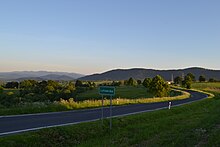
Lutowiska
| Lutowiska | ||
|---|---|---|

|
|
|
| Basic data | ||
| State : | Poland | |
| Voivodeship : | Subcarpathian | |
| Powiat : | Bieszczadzki | |
| Gmina : | Lutowiska | |
| Area : | 476.00 km² | |
| Geographic location : | 49 ° 15 ' N , 22 ° 42' E | |
| Residents : | 750 (2006) | |
| Postal code : | 38-713 | |
| Telephone code : | (+48) 013 | |
Lutowiska is a village in the Subcarpathian Voivodeship in the powiat of Bieszczadzki , Poland . It is also the seat of the rural community of the same name with around 2100 inhabitants.
Origin of name
The name Lutowiska is derived from the Russian litowzcze and means summer pastureland . It thus refers to the large high alpine pastures in the ridges of the Bieszczady, which were used by the local farmers as summer pastures for their cattle.
history
The place was established in the 16th century at the intersection of the trade route from Ushok Pass to Sanok with the road from Przemyśl to Beskydy Pass. Due to its convenient location, Lutowiska received from King August III in 1742 . the right to hold ten annual fairs. The Lutowiska cattle market is said to have been known beyond the borders. Long-horned Hungarian cattle, which were popular as draft oxen, were also traded there. From the beginning of the 18th century until 1919, Lutowiska also had town rights and was named after the town's founder, Ludwik Urbanski Urbanice . During the German occupation of Poland (1939-1944 / 45) Lutowiska belonged to the district chief Sanok . Many of Lutowiska's citizens were Jews. They were killed in June 1942. Their houses and the synagogue were destroyed.
From 1945 to 1951 Lutowiska was part of the Soviet Union and was called Shevchenko / Шевченко. It was then returned to Poland as part of a large area swap (then with the Polish name Szewczenko ) and was given its old name again in 1957. Lutowiska has been a national park municipality since the Bieszczady National Park was founded in 1973.
economy
The farming village and later trading town has been transformed into a tourist resort with numerous accommodation areas since the establishment of the national park . The offer ranges from hiking , cycling and horse riding to skiing (downhill and cross-country skiing) in winter. Hiking, riding and cycling paths are available, as is a ski lift. The high alpine pastures and peaks of the Bieszczady are special hiking destinations. Particular emphasis is placed on the development of sustainable tourism. The national park administration also offers environmental education . There are 12 nature trails in the Lutowiska municipality . In the upper Santal there is also a stud where Hutsul horses are bred.
local community
With an area of 476 km², it is also one of the largest municipalities in the country. The municipality is located in the San Valley on the northern edge of the Bieszczady , a low mountain range of the Carpathian Arc .
Attractions
- Lutowiska Jewish Cemetery
- Orthodox church from 1791 in the Smolnik district
- Catholic Church of St. Stanislaus in Lutowiska, built between 1911–1923.
Events
- Horse fair in July: Hutsul horses from the Jazdy Konne stud in the upper San Valley are also for sale.


