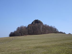
Lysá skála
| Lysá skála | ||
|---|---|---|
|
Lysá skála from the north |
||
| height | 419 m | |
| location | Czech Republic | |
| Mountains | Kummergebirge | |
| Coordinates | 50 ° 37 '49 " N , 14 ° 36' 30" E | |
|
|
||
| Type | Felsberg | |
| rock | basalt | |
The Lysá skála - now also called Spící panna - ( German Kahlstein , Kahler Stein ) is a 419 m high prominent rock mountain south of Česká Lípa in the Czech Republic . The mountain is part of the Provodínské Kameny ( Mikenhahn Stones ) mountain group and is a unique testimony to tertiary volcanism in Northern Bohemia. Since 1956, the 3.5 hectare mountain has been a protected Provodínské Kameny natural monument .
Location and surroundings
The Lysá skála is located about seven kilometers southeast of Česká Lípa ( Bohemian Leipa ). At its foot is the scattered municipality of Provodín ( Mikenhahn ).
view
Despite the low altitude, the view from the summit is very extensive. In the north, the view extends to the Lusatian Mountains , in the west to the Bohemian Central Mountains and in the south to the hilly forest landscape of the Kummergebirge and Daubaer Schweiz . To the east the view is limited by the wall of the Jeschkenkamm . Striking mountains in the field of view are the Ralsko ( Roll ), the Bezděz ( Bösig ), the Ronov ( Ronberg ) and the Vlhoš im ( Wilschtberg ).
Paths to the summit
- The mountain lies on a blue hiking route from Česká Lípa to Provodín. A fork leads to the foot of the summit structure. An ascent to the summit is possible with easy climbing.
- The railway stations Srní u České Lípy and Jestřebí u České Lípy on the Bakov – České Lípa railway line are also good starting points for visiting the mountain . The mountain can then be reached in about half an hour via the hiking trail mentioned above.

