Ralsko (mountain)
| Ralsko | ||
|---|---|---|
|
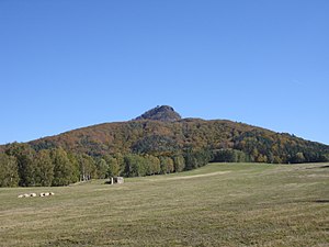
Ralsko seen from the west |
||
| height | 696 m | |
| location | Czech Republic | |
| Mountains | Ralská pahorkatina | |
| Coordinates | 50 ° 40 ′ 27 " N , 14 ° 45 ′ 57" E | |
|
|
||
| Type | Kegelberg | |
| rock | Tephrite | |
| Development | Construction of the castle in the 13th century | |
The Ralsko ( German Rollberg or Roll ) is a 696 m high, isolated lying cone mountain in the north of the Czech Republic . At its peak, the ruins of a Gothic is Ralsko Castle ( Roll castle ). The summit area has been under protection as a national nature reserve since 1967 .
Location and surroundings
The Ralsko is 16 km east of Česká Lípa ( Böhm. Leipa ) and 22 km west of Liberec ( Reichenberg ). At the foot of the mountain massif are the towns of Stráž pod Ralskem ( Wartenberg ), Mimoň ( Niemes ) and Ralsko ( Roll ) as well as the municipality of Noviny pod Ralskem ( Neuland ). The lying at Neuland is interesting tourist Polzendurchbruch ( Prurva Ploučnice ), formerly also Höllenschlund or Teufelsloch called where the Ploučnice ( Polzen ) flows through an artificial channel in the natural rock bolt. On the western flank of the mountain there is the Vranovské Skály rock group with the Julien view.
geology
The flanks of the mountain consist of clayey-sandy sedimentary rocks of the chalk , which was broken through by volcanic masses in the Tertiary . Furthermore, residues are deposited diluvial detritus and small outcrops of Olivinbasalt and sodalite - Phonolith present. The volcanic breakthrough raised the ceiling of medium-grain sandstone of the Upper Cretaceous ( Iser layer sequence ) at the base of the mountain, which is in contact with the mountain flank from the main northwest direction and is otherwise covered by basaltic rock. On the west side, these sandstones are exposed in the Vranovské skály rock group . The summit rock of the mountain consists of a tephrite , which forms an impressive block heap on the south side .
history
The first clear evidence of the existence of the Rollburg comes from the 14th century, but the first wooden castle complex was probably built in the 13th century. The oldest surviving parts of the castle are the two mighty residential towers , which were probably built in the 14th century. In the 15th century, the castle was obviously expanded again extensively, with a mighty shield wall , whose function is unclear given the location on a high mountain. The castle was conquered in 1468 by the troops of the Six Cities Association . A ruse was used for this, and they quickly entered the castle with the cattle returning from the pasture. In 1505 the castle is mentioned as being desolate.
At the beginning of the 20th century, the first (improper) maintenance measures were carried out on the ruins in order to preserve the facility for the future.
From 1905 the famous Kegelweg led over the summit, and more and more tourists visited the mountain. After 1945 the east side of the mountain was in the restricted area of the Ralsko military training area , so that the mountain was only accessible to a limited extent. Cyrillic inscriptions by the Soviet soldiers stationed there from 1968 are still visible on the ruins today. Marked hiking trails have again led to the summit since 1992.
Naming
The origin of the castle and mountain names roll, ral, ról, roi or roy allows different interpretations in old Germanic and Celtic dialects, as well as a biblical or Hebrew interpretation.
view
From Ralsko is a semi North Bohemia offers comprehensive 360 ° view, comparable only with the prospect of Milleschauer ( Milešovka ). So you have a beautiful view of the Lusatian Mountains with Harken and Hochwald , the ridge ( Ještěd ), the Greater and Lesser Bösig ( Bezděz ), the Bohemian Uplands with the High Geltsch ( Sedlo ), the Giant Mountains with Sněžka ( Sněžka ) but also on the sandstone mountains of northern Bohemia such as Daubaer Schweiz and Kummergebirge . In the east, your gaze wanders to the heights of the Bohemian Paradise ( Český ráj ), for example the ruins of Trosky Castle can be clearly seen.
There is also a beautiful view from the Juliina vyhlídka ( Julienshöhe ) at the foot of the southern flank of the mountain. From there your gaze wanders over the nearby Mimoň ( Niemes ) and on to the heights of the Daubaer Schweiz and the Kummergebirge .
Routes to the summit
- The former bowling path, which is now marked in red, runs over the mountain . This runs from Mimoň ( Niemes ), via Vranov ( Rabendorf ) and then ascending past the Juliina vyhlidka ( Julienhöhe ) to the summit with the ruins.
Individual evidence
- ^ V. Klein, M. Opletal (ed.): Geologická mapa ČR, List 03-31 Mimoň . Praha (ČGU) 1998, call number 17, 21, 25, 28, 30, 45
Web links
- The roll at Niemes by Mathias Scholz from Castles in Northern Bohemia
- www.podralsko.cz


