Vranov (Mimoň)
| Vranov | ||||
|---|---|---|---|---|
|
||||
| Basic data | ||||
| State : |
|
|||
| Region : | Liberecký kraj | |||
| District : | Česká Lípa | |||
| Municipality : | Mimoň | |||
| Area : | 201.1679 ha | |||
| Geographic location : | 50 ° 40 ′ N , 14 ° 45 ′ E | |||
| Height: | 311 m nm | |||
| Residents : | 50 (March 1, 2001) | |||
| Postal code : | 471 24 | |||
| License plate : | L. | |||
| traffic | ||||
| Street: | Mimoň - Stráž pod Ralskem | |||
Vranov (German Rabendorf ) is a district of the city of Mimoň in the Czech Republic . It is located two kilometers northeast of the center of Mimoň and belongs to the Okres Česká Lípa .
geography
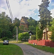
Vranov extends at the southwestern foot of the Ralsko ( Rollberg , 696 m) in the Ralská pahorkatina ( Rollberg hill country ). The sandstone cliffs of the Vranovské skály rise on the northern edge of the village . The Písčitý kopec (386 m) rises to the east. To the west lies the Ploučnice valley .
Neighboring towns are Noviny pod Ralskem in the North Malé Ralsko, Straz pod Ralskem and Velké Ralsko in the Northeast, the deserted village Svébořice the east, Pavlín, Novy Dvur and Wüsting Volmanova vila in the southeast, Hvězdov and Ploužnice in the south, Mimoň in the southwest and Pertoltice pod Ralskem and Srní Potok in the northwest.
history
The place was probably created in the 16th century. The first written mention of the village Rabendorf , which belonged to the Děvín rule , was made in 1549 in a certificate from Karl von Bieberstein about the Niemes church patronage . The indebted Karl von Bieberstein sold the desert castle Ralsko with the town of Niemes, Rabendorf and other places to Bohuslav Masanetz von Frimburg on June 19, 1578. On June 27, 1601 Johann Müllner von Mühlhausen acquired the property, while the place was listed as Rabendorf jinak (otherwise) Wranow . Müllner lost the rule of Niemes after the battle of the White Mountain . In 1623 the court chamber pledged the rule to Johann Zeidler called Hofmann , who three years later also inherited it. In 1651 the Zeidlers von Berbisdorf sold the rule to Johann Putz zu Adlersthurn. In 1688 Rabendorf consisted of 13 houses. From Adlersthurn's heiress, rule passed to the Counts of Hartig through marriage in 1705 .
In 1832 Rabendorf consisted of 25 houses with 169 German-speaking residents. A brick hut lay apart. Vicarage was Niemes. Because of the lack of water, a water pipe was built from a spring on the Rollberg in 1833. Four small ponds were created in the village, which were fed from underground springs. Until the middle of the 19th century Rabendorf remained subject to the allodial rule of Niemes.
After the abolition of patrimonial formed Rabendorf / Vranov after 1850 a part of the city Niemes in Bunzlauer county and judicial district Niemes . From 1868 Rabendorf belonged to the Bohemian Leipa district . In the same year Franz von Hartig had the Paulinenhof, named after his daughter Pauline, built instead of the brickworks, which was assigned to the Höflitz community . In 1883 Rabendorf and Rehwasser broke away from Niemes and formed the municipality of Rabendorf. In 1903 the village of Rabendorf consisted of 31 houses in which 165 people lived. In the first half of the 20th century the road from Niemes via Rabendorf to Rehwasser was built. The community of Rabendorf including Rehwasser had 216 inhabitants in 1930, of which 159 were in Rabendorf. Except for two inns, there were no businesses in the place. The inhabitants lived from agriculture and forestry or worked in the factories of Niemes. After the Munich Agreement , it was incorporated into the German Reich in 1938; initially Rabendorf belonged to the district of Böhmisch Leipa and since May 1, 1939 to the district of Deutsch Gabel . In 1939 there were 246 people living in the community. After the end of the Second World War, Vranov came back to Czechoslovakia. In 1946 and 1947, most of the German-Bohemian residents were expelled. In 1960 Vranov was incorporated into Mimoň. In 1965 there were 107 people in Vranov. In 1991 Vranov had 49 inhabitants. In 2001 the village consisted of 31 houses in which 50 people lived. In total, the place consists of 38 houses.
Local division
The cadastral district Vranov pod Ralskem includes the districts Vranov and Srní Potok .
Attractions
- Ralsko mountain with ruins of the castle of the same name
- Sandstone rock area Vranovské rocks with DŽBÁN ( whey pitcher ) and viewpoint Juliina vyhlídka ( Julienshöhe ). On the occasion of her 36th birthday, Franz von Hartig had the popular viewing rock converted into a viewing platform with a staircase carved into the rock, a railing and a wooden gloriette for his wife Juliane in 1822 . All that remains of the Gloriette is the circular rock cutout.
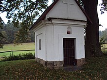
- Chapel, built in 1778
- Vranovská alej ( Kaiser-Franz-Joseph-Jubiläums-Allee ) between Vranov and Mimoň, the two-row linden alley was laid out in 1898 on the occasion of the 50th anniversary of the reign of Franz Joseph I.
Web links
Individual evidence
- ↑ http://www.uir.cz/katastralni-uzemi/695289/Vranov-pod-Ralskem
- ^ Eva Bayerová: Field names in the former judicial district of Niemes from the historical-geographical point of view (master's thesis) 2011
- ^ Johann Gottfried Sommer , Franz Xaver Maximilian Zippe The Kingdom of Böhmen, Vol. 2 Bunzlauer Kreis, 1834, p. 252
- ↑ http://www.joachim-richter.de/nie_seiten_hf/nie_hf_ Bezirk_orte_hantschel.html
- ^ Michael Rademacher: German administrative history from the unification of the empire in 1871 to the reunification in 1990. Landkreis Deutsch Gabel (Czech. Jablonné v Podjestedí). (Online material for the dissertation, Osnabrück 2006).
- ↑ http://www.czso.cz/csu/2009edicniplan.nsf/t/010028D080/$File/13810901.pdf


