Pertoltice pod Ralskem
| Pertoltice pod Ralskem | ||||
|---|---|---|---|---|
|
||||
| Basic data | ||||
| State : |
|
|||
| Region : | Liberecký kraj | |||
| District : | Česká Lípa | |||
| Area : | 791,5051 ha | |||
| Geographic location : | 50 ° 41 ' N , 14 ° 43' E | |||
| Height: | 284 m nm | |||
| Residents : | 399 (Jan. 1, 2019) | |||
| Postal code : | 471 24 | |||
| License plate : | L. | |||
| traffic | ||||
| Railway connection: | Řetenice – Lovosice – Česká Lípa – Liberec | |||
| structure | ||||
| Status: | local community | |||
| Districts: | 1 | |||
| administration | ||||
| Mayor : | Petr Selinger (as of 2009) | |||
| Address: | Pertoltice pod Ralskem 165 471 24 Mimoň |
|||
| Municipality number: | 514276 | |||
| Website : | www.pertoltice.cz | |||
| Location of Pertoltice pod Ralskem in the Česká Lípa district | ||||

|
||||
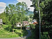
Pertoltice pod Ralskem (German Barzdorf am Rollberge ) is a municipality in the Okres Česká Lípa in the Liberec region in the north of the Czech Republic . It lies at the foot of Ralsko (Rollberg) about 13 kilometers east of Česká Lípa (Česká Lípa) and 4 kilometers north of Mimoň (Niemes) in the valley of the creek Panenský Potok (Jungfernbach) .
From the middle of the 19th century, Barzdorf am Rollberge formed a municipality in the judicial district of Niemes or in the Bohemian Leipa district .


