
Mórichida
| Mórichida | |||||
|
|||||
| Basic data | |||||
|---|---|---|---|---|---|
| State : | Hungary | ||||
| Region : | Western Transdanubia | ||||
| County : | Győr-Moson-Sopron | ||||
| Small area until December 31, 2012 : | Tét | ||||
| District since 1.1.2013 : | Tét | ||||
| Coordinates : | 47 ° 31 ' N , 17 ° 25' E | ||||
| Area : | 32.30 km² | ||||
| Residents : | 815 (Jan. 1, 2011) | ||||
| Population density : | 25 inhabitants per km² | ||||
| Telephone code : | (+36) 96 | ||||
| Postal code : | 9131 | ||||
| KSH kódja: | 02556 | ||||
| Structure and administration (as of 2015) | |||||
| Community type : | local community | ||||
| Mayor : | Attila László (independent) | ||||
| Postal address : | Fő u. 131. 9131 Mórichida |
||||
| Website : | |||||
| (Source: A Magyar Köztársaság helységnévkönyve 2011. január 1st at Központi statisztikai hivatal ) | |||||


Mórichida is a Hungarian community in the county Tét in Győr-Moson-Sopron County . It is located about 30 kilometers southwest of Győr on the right bank of the Marcal River .
Attractions
- Roman Catholic Church of St. James ( Szent Jakab apostol templom ), originally built in 1251, between Mórichida and Árpás located
- Evangelical Church, built in 1789
- Vineyard with historic wine cellars from the beginning of the 19th century
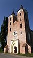
Catholic Church Szent Jakab apostol
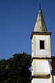
Evangelical Church in Mórichida

Marcal near Mórichida


sons and daughters of the town
- Dániel Fehér (1890–1955), forest engineer and biologist
traffic
Roads No. 8419 and No. 8421 meet in the village. The nearest train station is about ten kilometers west in Egyed-Rábacsanak.
Web links
- Mórichida ( Hungarian )
- Mórichida (Hungarian)
- Mórichida in A Pallas nagy lexikona (Hungarian)