Mühlbach (Rur)
| Mühlbach | ||
|
View towards the mouth of the Rur |
||
| Data | ||
| Water code | DE : 28233? | |
| location | Evenings , city of Nideggen , North Rhine-Westphalia , Germany | |
| River system | Rhine | |
| Drain over | Rur → Maas → Hollands Diep → North Sea | |
| River basin district | Meuse | |
| source | East of Evenings 50 ° 40 ′ 11 ″ N , 6 ° 29 ′ 35 ″ E |
|
| Source height | 236 m above sea level NN | |
| muzzle | In evenings in the Rur coordinates: 50 ° 40 ′ 15 ″ N , 6 ° 28 ′ 40 ″ E 50 ° 40 ′ 15 ″ N , 6 ° 28 ′ 40 ″ E |
|
| Mouth height | 183 m above sea level NN | |
| Height difference | 53 m | |
| Bottom slope | 41 ‰ | |
| length | 1.3 km | |
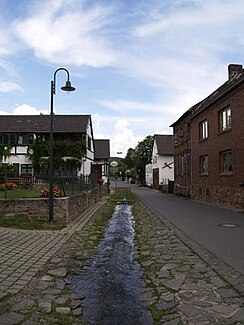
The Mühlbach rises at the upper end of Mühlbachstrasse in the village of Abenden , which belongs to the city of Nideggen .
On its way to the Rur , water is taken from the spring, which is treated and fed into the local drinking water network. On its way to the Rur, the approx. 1.3 km long stream flows through the center of the village. There it flows under the road and comes back to light across from an old farm. At the end of the village it falls down a small waterfall and flows again underground to the Rur. It reappears next to the Rur bridge and immediately flows into the Rur.
Mill
A mill above the village is first mentioned in 1570. Its owner was the mayor of Bürvenich.
Individual evidence
- ↑ a b c German basic map 1: 5000
- ^ City of Nideggen
