
Friedrich Wilhelm Canal
The Friedrich Wilhelm Canal , previously the Müllroser Canal , was the first canal to connect the Oder with the Spree . From Brieskow an der Oder the canal, which was completed in 1668 and has a length of approx. 27 km, led to Neuhaus an der Spree .

history
In 1558, Emperor Ferdinand I and Elector Joachim II decided, with the Treaty of Müllrose, to build the canal that would connect the Habsburg possessions of Bohemia and Silesia to the North Sea via the Oder, Spree, Havel and Elbe . The emperor began excavating in the following years and so the western section, the so-called Kaisergraben or Alter Graben , between Neuhaus and Müllrose was completed. Due to lack of money, the construction work was stopped in 1564 at the latest.
After the Swedes gained control of Stettin in 1630 and threatened to block the Oder, the canal project became topical again. In 1662, under Elector Friedrich Wilhelm, work began on the eastern construction section and in 1668 the canal between Müllrose and Brieskow was completed, with parts of the lower reaches of the Schlaube being expanded like a canal. The difference in height between the Spree and the apex position at Müllrose was approx. 3.8 m and between the apex position and the Oder, depending on the water level of the Oder, up to approx. 23 m. A total of 13 locks were initially used for this purpose. The entire canal was named after Friedrich Wilhelm. After their victory over the Prussian army in the battle of Kunersdorf in 1759, Austrian and Russian troops destroyed parts of the canal systems.
The canal was the most important link between Hamburg , Berlin and Breslau for over 200 years . The reduction in freight costs associated with canal shipping had a significant economic impact on the cities mentioned. From the 1860s the canal increasingly reached its capacity limit, so in 1886 it was decided to build the Oder-Spree Canal . A part of the Friedrich Wilhelm Canal - 11.3 km from the former bush lock (2.5 km northeast of Neuhaus) to Schlaubehammer - was used to build the Oder-Spree Canal . The section from the Wergensee to the Oder-Spree Canal ( Neuhauser Feed Canal ) has served to feed the apex of the canal since 1892.
The 13 km long old section has been called the Brieskower Canal since 1951 . It branches off from the Oder-Spree Canal near the Groß Lindow district of Schlaubehammer and flows north of Brieskow-Finkenheerd at the end of the 3 km long Brieskower See into the Oder at 576.72 km.
After the opening of the Oder-Spree Canal in 1891, the Friedrich Wilhelm Canal lost its importance as a waterway. Since 1992, the municipalities try on Brieskower channel that it is used for tourism purposes: It restored the channel monument at the lock Weissenberg, reconstructed the former towpath between the locks White Spring and hammer Fort and built an old Baukahn to Treidelkahn with a capacity for 60 people around.
In the years after 2000, an asphalt bike path ( Oder-Spree-Tour ) was built along the canal and the Kaisermühl ferry was replaced by a pedestrian and cyclist bridge. The old ferry was dropped on the bank.
The Anglerverein Linde 35 eV Groß Lindow is committed to the care and maintenance of the fish population and the maintenance of the canal. The popular fishing days, made public through the German Anglers' Association, attract anglers from all over Germany .
photos
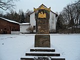
Memorial to the bicentenary of the canal in 1869 in Groß Lindow

At the old ferry in Kaisermühl, pedestrian bridge over the canal in the background
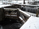
Lock in Groß Lindow


literature
- Hans-Joachim Uhlemann: Berlin and the Märkische waterways. transpress Verlag, Berlin 1987, ISBN 3-344-00115-9 .
- Writings of the Association for European Inland Shipping and Waterways eV various years. Western European shipping and port calendar Binnenschifffahrts-Verlag GmbH Duisburg-Ruhrort, OCLC 48960431 .
- Council of the city of Müllrose (ed.): Müllrose - gate to the Schlaubetal. 1984.
cards
- Folke Stender: Editing of Sportschifffahrtskarten inland 1. Nautical publication Verlagsgesellschaft, ISBN 3-926376-10-4 .
- W. Ciesla, H. Czesienski, W. Schlomm, K. Senzel, D. Weidner: Shipping maps of the inland waterways of the German Democratic Republic 1: 10,000. Volume 4. Editor: Waterways Authority of the GDR, Berlin 1988, OCLC 830889996 .