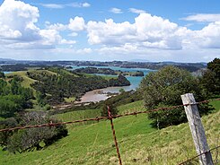
Mahurangi Harbor
| Mahurangi Harbor | ||
| Geographical location | ||
|
|
||
| Coordinates | 36 ° 28 ′ S , 174 ° 43 ′ E | |
| Region ISO | NZ-AUK | |
| country | New Zealand | |
| region | Auckland | |
| Sea access | Hauraki Gulf , Pacific Ocean | |
| Data on the natural harbor | ||
| Port entrance | 1 330 m wide | |
| length | around 10.7 km | |
| width | max 2.5 km | |
| Coastline | around 57 km | |
| places | Warkworth , Snells Beach , Mahurangi and Mahurangi West | |
| Tributaries | Mahurangi River , Te Kapa River and numerous streams (brooks) | |
| Islands | Pudding Island, Casnell Island, Grants Island | |
| Jetty | Mahurangi , upstream at Warkworth on the Mahurangi River | |
| Photography of the natural harbor | ||
 Mahurangi Harbor |
||
Mahurangi Harbor is a natural harbor in the Auckland Council urban areaon the North Island of New Zealand .
geography
The Mahurangi Harbor is located about 5 km south-east of the center of Warkworth on the east coast of Northland Peninsula .
The body of water, which comes to a maximum length of around 10.7 km, is widely ramified with a coastline of around 57 km and has the Pukapuka Inlet , Dyers Creek , Huawai Bay , Brownes Bay , Cowan Bay and the Branch, which is called Te Kapa River , but is like an inlet, several arms and two peninsulas reaching into the water. The main arm of the natural harbor varies in width between around 600 m and a maximum of 2.5 km. The harbor entrance, in which the small island Pudding Island is located, measures a width of around 1330 m. Two other islands, Casnell Island and Grants Island , are in the main branch of the port.
use
The bays and side arms are used for oyster farming . At the beginning of 2017, the Ministry for Primary Industries issued a warning against the harvest and consumption of oysters from the port area. The mussels were infected with norovirus , which causes severe gastroenteritis .
Panoramic photo
See also
Individual evidence
- ↑ Topo250 maps . Land Information New Zealand , accessed January 18, 2018 .
- ↑ Coordinates and longitudes were partly made using Google Earth Version 7.1.8.3036 on January 18, 2018.
- ↑ Continued warning to avoid oysters from Mahurangi Harbor . Ministry for Primary Industries , February 10, 2017, accessed January 18, 2018 .

