Manakara (city)
| Manakara | ||
|---|---|---|
|
|
||
| Coordinates | 22 ° 9 ′ S , 48 ° 0 ′ E | |
| Basic data | ||
| Country | Madagascar | |
| region | Vatovavy-Fitovinany | |
| ISO 3166-2 | MG | |
| District | Manakara | |
| height | 6 m | |
| Residents | 35,905 (2005) | |
Manakara is a city on the east coast of Madagascar with almost 36,000 inhabitants (as of 2005).
geography
Manakara is the capital of the Vatovavy-Fitovinany region on the east coast of Madagascar. The city consists of the two districts Tanambato in the west and Manakare Be in the east, which are separated by the Manakara River and the Canal des Pangalanes . The first is a traffic junction and trading center, while the second district is more likely to be inhabited by wealthy people. The Manakara River flows into the Indian Ocean in the city .
Manakara is 590 km from the capital Antananarivo .
climate
Manakara has a tropical rainforest climate (Af). The annual average temperature is 22.9 ° C.
|
Average monthly temperatures and rainfall for Manakara
Source: climate-data.org
|
||||||||||||||||||||||||||||||||||||||||||||||||||||||||||||||||||||||||||||||||||||||||||
Economy and Infrastructure
13.8% of the inhabitants of Manakara live from agriculture, where they grow rice, tangerines, cassava , coffee and bananas. 30% each live from fishing or work in industry. 25% earn their living in the service sector. 1.2% live from animal husbandry.
traffic

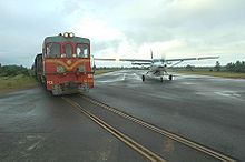
With the completion of the Fianarantsoa – Manakara railway line in 1936, the city has become an important transshipment point with an important port. North of Manakara is the city's own airport with Air Madagascar connections to Fianarantsoa and Tolagnaro . The Fianarantsoa – Manakara railway line runs along the runway at this airport. The Canal des Pangalanes connects the city with Toamasina and ensures a lively exchange of goods. Likewise, the Route nationale 12 leads through Manakara with which one reaches the northern Irondro and the southern Vangaindrano .
population
The population grew from 19,768 to 24,970 between 1975 and 1993. In 2005, almost 36,000 people lived in the city.
The place is in the settlement area of the Muslim Antaimoro . But ethnic groups ( Foko ) such as the Antaisaka , Betsileo , Betsimisaraka and Merina have immigrated. Chinese and Europeans also live in the city.
sons and daughters of the town
- Benjamin Marc Ramaroson (* 1955), Archbishop of Antsiranana
Town twinning
Web links
Individual evidence
- ↑ 2005 population estimates for cities in Madagascar. mongabay.com, accessed October 1, 2017 .
- ↑ Climate & Weather in Manakara. climate-data.org, accessed on October 1, 2017 .
- ↑ Census 2001. (Excel) Cornell University , December 31, 2001, accessed October 1, 2017 (French, 2.4 MB).
