Manrode
|
Manrode
City of Borgentreich
Coordinates: 51 ° 35 ′ 1 ″ N , 9 ° 20 ′ 27 ″ E
|
|
|---|---|
| Height : | 297 m |
| Area : | 5.09 km² |
| Residents : | 531 |
| Population density : | 104 inhabitants / km² |
| Incorporation : | 1st January 1975 |
| Postal code : | 34434 |
| Area code : | 05643 |
|
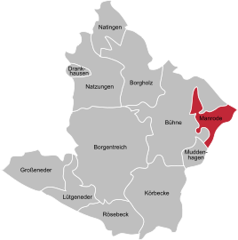
Location of Manrode in Borgentreich
|
|
Manrode is a district of the East Westphalian town of Borgentreich in the Höxter district in North Rhine-Westphalia . State road 763 runs through the village .
history
Manrode was first mentioned in 1009 as Ananroth , in the " Vita Meinwerci " in the records of Bishop Meinwerk, who was bishop in Paderborn from 1009 to 1036. The spelling of the place name has changed several times in the centuries up to today's manrode.
The village of Manrode, first mentioned in 1015 under the name Ananroth, also belonged to the parish of Bühne . The place is later mentioned in the Corveyer and Helmarshausen registers of goods. The place name indicates that Manrode was created on younger cleared soil and did not emerge from any existing settlement (see -rode ).
On January 1, 1975 Manrode was incorporated into the town of Borgentreich.
politics
Detlef Unger (CDU) is the mayor .
Web links
- Information on Manrode on Borgentreich.de (PDF; 19 kB)
- Manrode.de
- Manrode in the Westphalia Culture Atlas
Individual evidence
- ^ Federal Statistical Office (ed.): Historical municipality directory for the Federal Republic of Germany. Name, border and key number changes in municipalities, counties and administrative districts from May 27, 1970 to December 31, 1982 . W. Kohlhammer, Stuttgart / Mainz 1983, ISBN 3-17-003263-1 , p. 328 .

