Manti-La Sal National Forest
|
Manti-La Sal National Forest
|
||
|
La Sal Mountains from Arches National Park seen from |
||
| location | Utah , United States | |
| surface | 5718 km² | |
| Geographical location | 38 ° 31 ' N , 109 ° 15' W | |
|
|
||
| administration | US Forest Service | |
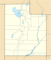
The Manti-La Sal National Forest is a 5,718 sq km large National Forest of the US federal government in eastern Utah in the United States . A small part extends to the west of the state of Colorado .
geography
location
The National Forest is located in eastern Utah in the counties of San Juan , Sanpete , Emery , Utah , Grand , Carbon and Sevier . A smaller part is east of the border in the far west of Colorado in Montrose County and Mesa County .
The La Sal Mountain loop road leads from Castle Valley over Geyser Pass back to Moab. In the forest you can find, among other things, Oowah Lake .
structure
The forest area is divided into three parts, the San Pitch Division , the Manti Division and the LaSal Division . These are administered in a total of five ranger districts . There are district offices in Ferron , Price , Ephraim , Moab, and Monticello .
The Manti Division roughly corresponds to the boundaries of the Wasatch Plateau , which is part of the Colorado Plateau . The east side is formed by steep walls, in the west it merges into the surrounding valleys. It ranges from approximately 2,740 m (9,000 feet ) to 3,440 m (11,300 ft) in altitude. The San Pitch Division encloses the northern part of the Gunnison Plateau , also known as the San Pitch Mountains . The area lies at altitudes of around 1700 m to 2740 m . The LaSal Division includes mountain landscapes as well as mesas and canyons and is characterized by the La Sal Mountains , which reach a maximum height of 3877 meters with Mount Peale , and by the Abajo Mountains . The area covers areas between 1830 m and almost 3900 m altitude.
use
The US Forest Service slogan for its national forests is Land of many uses . Like all national forests, the Manti-La Sal National Forest is used commercially through forestry , grazing and licenses for mineral extraction . The Manti-La Sal National Forest is particularly attractive for recreational and leisure use due to its location.
Under the Manti-La Sal National Forest lie parts of a complex of uranium and vanadium mines, which were originally called the Pandora Mine and later the La Sal Mines Complex . An exploration of further uranium deposits on the Elk Ridge, which was requested in 2010, did not come about.
The recreational uses of the area include, in addition to hunting and fishing, above all off-road trails for quads , a winter sports area especially for snowboarders and hundreds of kilometers of hiking trails, a designated mountain bike route exactly the length of a marathon under the name The Whole Enchilada and Campsites with or without equipment.
Since 1984, the Manti La Sal National Forest has designated the Dark Canyon Wilderness as a wilderness area . This strictest class of nature reserves in the United States is only permitted on foot or on horseback, and any mechanical means of transport, including bicycles, are prohibited.
Web links
Individual evidence
- ↑ About the Forest , United States Forest Service, fs.usda.gov, accessed August 8, 2019.
- ↑ Land and Resorce management plan. (PDF; 19.8 MB) United States Department of Agriculture, Forest Service, pp. 13-14 , accessed on August 8, 2019 .
- ↑ Land and Resorce management plan. (PDF; 19.8 MB) United States Department of Agriculture, Forest Service, p. 31 , accessed on August 8, 2019 .
- ↑ a b Land and Resorce Management Plan. (PDF; 19.8 MB) United States Department of Agriculture, Forest Service, pp. 17-21 , accessed on August 8, 2019 .
- ↑ Offices , fs.usda.gov, accessed on August 8, 2019 (English)
- ^ Uranium Watch: Pandora accessed August 8, 2019
- ^ US Forest Service: Marcy Look Project, accessed August 8, 2019
- ^ US Forest Service: Manti La Sal National Forest - Recreation
- ↑ Wilderness.net: Dark Canyon Wilderness

