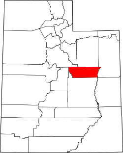
Carbon County, Utah
| administration | |
|---|---|
| US state : | Utah |
| Administrative headquarters : | Price |
| Foundation : | 1894 |
| Demographics | |
| Residents : | 21,403 (2010) |
| Population density : | 5.6 inhabitants / km 2 |
| geography | |
| Total area : | 3845 km² |
| Water surface : | 16 km² |
| map | |
| Website : www.uen.org/counties/carbon.html | |
Carbon County is a county in the state of Utah in the United States . The largest place and seat of the county seat is Price . In 2010, Carbon County had a population of 21,403.
history
Carbon County was founded in 1894; it got its name from the coal deposits in this region.
geography
Carbon County covers an area of 3845 square kilometers, 16 square kilometers of which is water. Range Creek (Colorado River) has its source north of East Carbon . It is bordered clockwise by the counties: Duchesne County , Uintah County , Emery County , Grand County , Sanpete County, and Utah County .
Demographic data
| growth of population | |||
|---|---|---|---|
| Census | Residents | ± in% | |
| 1900 | 5004 | - | |
| 1910 | 8624 | 72.3% | |
| 1920 | 15,489 | 79.6% | |
| 1930 | 17,798 | 14.9% | |
| 1940 | 18,459 | 3.7% | |
| 1950 | 24,901 | 34.9% | |
| 1960 | 21,135 | -15.1% | |
| 1970 | 15,647 | -26% | |
| 1980 | 22,179 | 41.7% | |
| 1990 | 20,228 | -8.8% | |
| 2000 | 20,422 | 1 % | |
| 2010 | 21,403 | 4.8% | |
| 1900-1990
2000 2010 |
|||

Carbon County had a population of 20,422 people as of the 2000 census . There were 7,413 households and 5,381 families. The population density was 5 people per square kilometer. The racial the population was composed of 91.08% White, 0.27% African American, 1.06% Native American, 0.35% Asian, 0.04% Pacific Islander, and 4.75% other races Groups; 2.44% from two or more races. Hispanic or Latino of any race was 10.27% of the population.
Of the 7,413 households, 36.90% had children and adolescents under the age of 18 living with them. 58.20% were married couples living together, 10.00% were single mothers. 27.40% were not families. 23.80% were single households and 11.00% had someone who was 65 years of age or older. The average household size was 2.68 and the average family size was 3.19.
For the entire county, the population was composed of 28.80% of residents under the age of 18, 12.30% between 18 and 24 years of age, 24.40% between 25 and 44 years of age, and 21.30% between 45 and 64 years of age 13.30% were 65 years of age or over. The median age was 34 years. For every 100 females there were 95.60 males, and for every 100 females aged 18 and over there were 93.00 males.
The median income for a household in the county is $ 34,036 , and the median income for a family is $ 40,900. Males had a median income of $ 38,957 versus $ 21,141 for females. The per capita income was $ 15,325. 13.40% of the population and 10.00% of families are below the poverty line. 14.50% of these were under 18 years of age and 13.10% were 65 years of age or older.
towns and places
Individual evidence
- ↑ Carbon County in the United States Geological Survey's Geographic Names Information System . Retrieved February 22, 2011
- ↑ Extract from Census.gov . Retrieved February 28, 2011
- ↑ Excerpt from factfinder.census.gov.Retrieved February 28, 2011
- ↑ Missouri Census Data Center ( Memento of the original from January 15, 2013 in the Internet Archive ) Info: The archive link was inserted automatically and has not yet been checked. Please check the original and archive link according to the instructions and then remove this notice. Retrieved October 12, 2012
Web links
- Carbon County (English)
Coordinates: 39 ° 38 ′ N , 110 ° 35 ′ W


