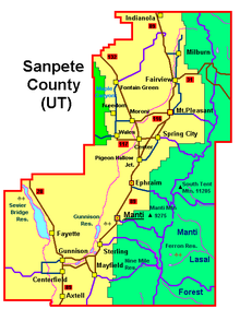
Sanpete County
 Sanpete County Courthouse |
|
| administration | |
|---|---|
| US state : | Utah |
| Administrative headquarters : | Manti |
| Foundation : | 1852 |
| Demographics | |
| Residents : | 27,822 (2010) |
| Population density : | 6.8 inhabitants / km 2 |
| geography | |
| Total area : | 4151 km² |
| Water surface : | 38 km² |
| map | |
Sanpete County is a county in the state of Utah in the United States . The county seat is Manti , the largest town is Ephrahim with around 4500 inhabitants.
geography
Sanpete County covers an area of 4,151 square kilometers (1,603 mi²), of which 38 square kilometers are water. The county is bounded to the east by the Wasatch Plateau . Here it reaches heights of up to 3300 m. Most of the Wasatch Plateau is surrounded by the Manti-La Sal National Forest . The county is bordered by counties in a clockwise direction: Utah County , Carbon County , Emery County , Sevier County , Millard County, and Juab County .
Worth seeing
The Huntington / Eccles Canyon National Scenic Byway leads from Fairview to Huntington on State Road 31. This partly very windy section reaches heights of over 3300 m. Snow in June / July is still possible there.
Demographic data
| growth of population | |||
|---|---|---|---|
| Census | Residents | ± in% | |
| 1850 | 365 | - | |
| 1860 | 3815 | 945.2% | |
| 1870 | 6786 | 77.9% | |
| 1880 | 11,557 | 70.3% | |
| 1890 | 13,146 | 13.7% | |
| 1900 | 16,313 | 24.1% | |
| 1910 | 16,704 | 2.4% | |
| 1920 | 17,505 | 4.8% | |
| 1930 | 16,022 | -8.5% | |
| 1940 | 16,063 | 0.3% | |
| 1950 | 13,891 | -13.5% | |
| 1960 | 11,053 | -20.4% | |
| 1970 | 10,976 | -0.7% | |
| 1980 | 14,620 | 33.2% | |
| 1990 | 16,259 | 11.2% | |
| 2000 | 22,763 | 40% | |
| 2010 | 27,822 | 22.2% | |
| Before 1900
1900-1990 2000 |
|||
Sanpete County's population was 22,763 as of the 2000 census . There were 6,547 households and 5,067 families. The population density was 6 people per square kilometer. The racial the population was composed of 92.43% White, 0.31% African American, 0.87% Native American, 0.48% Asian, 0.36% Pacific Islander, and 4.06% other races Groups; 1.49% from two or more races. Hispanic or Latino of any race was 6.63% of the population.
Of the 6,547 households, 43.40% had children and adolescents under the age of 18 living with them. 67.00% were married couples living together, 7.20% were single mothers. 22.60% were not families. 17.80% were single households and 10.10% had someone who was 65 years of age or older. The average household size was 3.27 and the average family size was 3.68 people.
For the entire county, the population was composed of 33.20% residents under 18 years of age, 16.40% between 18 and 24 years of age, 21.80% between 25 and 44 years of age, 17.80% between 45 and 64 years of age 10.80% were 65 years of age or over. The average age was 25 years. For every 100 females there were 102.40 males, and for every 100 females aged 18 and over there were 100.90 males.
The median income for a household in the county is $ 33,042 , and the median income for a family is $ 37,796. Males had a median income of $ 30,527 versus $ 19,974 for females. The per capita income was $ 12,442. 15.90% of the population and 10.40% of families are below the poverty line. 13.90% of them were under 18 years of age and 9.60% were 65 years of age or older.
towns and places
Individual evidence
- ^ Sanpete County in the Geographic Names Information System of the United States Geological Survey . Retrieved February 22, 2011
- ^ US Census Bureau _ Census of Population and Housing . Retrieved February 28, 2011
- ↑ Extract from Census.gov . Retrieved February 28, 2011
- ↑ Excerpt from factfinder.census.gov.Retrieved February 28, 2011
Coordinates: 39 ° 22 ′ N , 111 ° 35 ′ W


