Monticello, Utah
| Monticello | ||
|---|---|---|
 The San Juan County Courthouse in Monticello |
||
| Location in Utah | ||
|
|
||
| Basic data | ||
| Foundation : | 1888 | |
| State : | United States | |
| State : | Utah | |
| County : | San Juan County | |
| Coordinates : | 37 ° 52 ′ N , 109 ° 21 ′ W | |
| Time zone : | Mountain ( UTC − 7 / −6 ) | |
| Residents : | 1,972 (as of 2010) | |
| Population density : | 294.3 inhabitants per km 2 | |
| Area : | 6.7 km 2 (approx. 3 mi 2 ) of which 6.7 km 2 (approx. 3 mi 2 ) is land |
|
| Height : | 2155 m | |
| Postal code : | 84535 | |
| Area code : | +1 435 | |
| FIPS : | 49-51580 | |
| GNIS ID : | 1443568 | |
| Website : | www.monticelloutah.org | |
| Mayor : | Douglas L. Allen | |
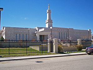
 Mormon temple in Monticello |
||
Monticello is a small town (with the status " City ") and the administrative seat of San Juan County in the US -amerikanischen State Utah . In 2010 Monticello had 1972 inhabitants.
Monticello is conveniently located for touring Canyonlands National Park .
history
Cowboys, Indian tribes and outlaws were the first to inhabit the mountains and valleys around Monticello. In 1887 the place was settled by Mormons . Monticello got the name in memory of Thomas Jefferson's real estate in Virginia . In the beginning there was a lot of unrest between the settlers, the cowboys and the Indians. This was due to a gold and silver rush in the area. Monticello became the county seat in 1895 and merged as a city in 1910.
From 1942 and increasingly after the Second World War until 1960, the largest uranium mining in the United States was operated in Monticello. Uranium ore and vanadium were mined and processed in the open pit . The dumps with the dead rock were in the open air and led to one of the greatest environmental disasters in the United States. The Environmental Protection Agency declared Monticello a superfund site and decontaminated the area between 1991 and 2004. Barriers and filter systems were built deep below the ground level to protect the groundwater from further runoff from the dumps. The groundwater resources of the place are contaminated and cannot be used permanently under any circumstances. Soil and groundwater are monitored over the long term.
geography
Monticello is the second largest city in San Juan County after Blanding . It is located in southeastern Utah on Highway 491 (old 666) and Highway 191, 10 km east of the Abajo Mountains and around 100 km south of Arches National Park . Here is the southern entrance to Canyonlands National Park.
Demographic data
| Population development | |||
|---|---|---|---|
| Census | Residents | ± in% | |
| 1890 | 115 | - | |
| 1900 | 180 | 56.5% | |
| 1910 | 375 | 108.3% | |
| 1920 | 768 | 104.8% | |
| 1930 | 496 | -35.4% | |
| 1940 | 667 | 34.5% | |
| 1950 | 1172 | 75.7% | |
| 1960 | 1845 | 57.4% | |
| 1970 | 1431 | -22.4% | |
| 1980 | 1929 | 34.8% | |
| 1990 | 1806 | -6.4% | |
| 2000 | 1958 | 8.4% | |
| 2010 | 1972 | 0.7% | |
| 1890-2000 2010 | |||
According to the 2010 census , there were 1972 people in 615 households in Monticello. The population density was 294.3 people per square kilometer. Statistically, 3.05 people lived in each of the 615 households.
The racial the population was composed of 84.9 percent white, 0.4 percent African American, 6.4 percent Native American, 0.7 percent Asian and 4.6 percent from other ethnic groups; 3.0 percent were descended from two or more races. Hispanic or Latino of any race was 13.4 percent of the population.
33.8 percent of the population were under 18 years old, 52.5 percent were between 18 and 64 and 13.7 percent were 65 years or older. 47.4 percent of the population was female.
The average annual income for a household was 44,938 USD . The per capita income was $ 16,887. 10.5 percent of the population lived below the poverty line.
Individual evidence
- ↑ a b c American Fact Finder. Retrieved May 9, 2013
- ↑ PA: EPA Superfund Program: MONTICELLO MILL TAILINGS (USDOE), MONTICELLO, UT
- ^ US Decennial Census. Retrieved May 9, 2013
