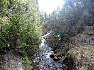
Marchbach (Grundache)
| Marchbach | ||
|
Marchbach at an altitude of approx. 1150 m. |
||
| Data | ||
| Water code | AT : 2-8-224-6 | |
| location | Tyrol ( Austria ) | |
| River system | Danube | |
| Drain over | Brandenberger Ache → Inn → Danube → Black Sea | |
| source | northwest of the Vitusberg in the Mangfall Mountains 47 ° 34 ′ 46 ″ N , 11 ° 56 ′ 54 ″ E |
|
| Source height | 1457 m above sea level A. | |
| muzzle | in front of the Erzherzog-Johann-Klause in the Grundache Coordinates: 47 ° 35 '13 " N , 11 ° 53' 45" E 47 ° 35 '13 " N , 11 ° 53' 45" E |
|
| Mouth height | 804 m above sea level A. | |
| Height difference | 653 m | |
| Bottom slope | 11% | |
| length | 6.1 km | |
| Catchment area | 10.2 km² | |
The Marchbach is a year-round flowing water in the Mangfall Mountains in Tyrol .
It arises northwest below Veitsberg and flows in a largely westward direction up to its confluence with the Grundache, which is called Brandenberger Ache from then on .
Individual evidence
- ↑ a b c d tiris - Tyrolean spatial information system
- ↑ Susanne Gurschler: 111 places in Tyrol that you have to see. 55_The Brandenberger Ache. Emons Verlag, 2016, ISBN 3960410441 ( limited preview in Google Book Search)
