Margalef
| Margalef municipality | ||
|---|---|---|
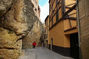
 Village street in Margalef
|
||
| coat of arms | Map of Spain | |

|
|
|
| Basic data | ||
| Autonomous Community : | Catalonia | |
| Province : | Tarragona | |
| Comarca : | Priory (comarca) | |
| Coordinates | 41 ° 17 ′ N , 0 ° 45 ′ E | |
| Height : | 379 msnm | |
| Area : | 34.7 km² | |
| Residents : | 97 (Jan. 1, 2019) | |
| Population density : | 2.8 inhabitants / km² | |
| Postal code : | 43371 | |
| Municipality number ( INE ): | 43075 | |
| administration | ||
| Official language : | Castilian , Catalan | |
| Mayor : | Ramon Vilà i Bru | |
| Website : | www.margalef.altanet.org | |
Margalef is a Catalan town in the province of Tarragona in northeastern Spain . It is in the Comarca Priorat . Margalef has 97 inhabitants (as of January 1, 2019).
Geographical location
Margalef is about 2.5 km east of La Bisbal de Falset on the western edge of the Montsant Nature Park on the T-713.
Sports
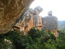
Margalef is a world famous sport climbing area . There are some well-known and very difficult routes with z. B. "Era Vella" ( 9a French ) and "First Round First Minute" (9b French). Both routes were first climbed by Chris Sharma .
Web links
Commons : Margalef - collection of images, videos and audio files
swell
- ↑ Cifras oficiales de población resultantes de la revisión del Padrón municipal a 1 de enero . Population statistics from the Instituto Nacional de Estadística (population update).

