Mariahilf (Vienna district)
| Mariahilf | |
|---|---|
| coat of arms | map |

|

|
Mariahilf was an independent municipality until 1850 and is now a district of Vienna in the 6th district of Mariahilf . Parts of the old local area are now in the 7th district of Neubau .
coat of arms
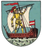
The coat of arms of Mariahilf shows Don Juan de Austria on a ship who, according to legend, owes his victory over the Ottomans in the naval battle of Lepanto in 1571 to the assistance of St. Mary .
Origin of name
The name Mariahilf can be traced back to a copy of the miraculous image of Mariahilf by Lucas Cranach the Elder , which was located in a chapel of the cemetery built by the Barnabites in this area in 1660 . This picture is now in the Mariahilfer Church .
history
The village of Mariahilf emerged from three vineyards, in the middle of which the first house was built in the 1570s. Until the middle of the 17th century this was the only house in this area. After that, the area began to be settled around a cemetery chapel built by the Barnabites, which formed the center of the later town.
The convenient location on today's Mariahilfer Strasse , which led to Linz and Schönbrunn , had a positive effect on the further development of the suburb. In 1850 Mariahilf was incorporated together with Gumpendorf , Laimgrube , Windmühle and Magdalenengrund as the 5th district of Mariahilf. In 1861 the Mariahilf district became the 6th district due to the division of Wiedens , a year later it lost the parts beyond Mariahilfer Strasse (i.e. also part of the former suburb of Mariahilf) to the 7th district Neubau.
Personalities
- Carl Geyling (1814–1880), glass and landscape painter
- Josef Neumayer (1844–1923), Mayor of Vienna
- Josef Strauss (1827–1870), architect, inventor, composer and conductor
- Eduard Swoboda (1814–1902), portrait, genre and history painter
Web links
- The suburb of Mariahilf on the wien.at website
- District history of Mariahilf ( Memento from October 8, 2007 in the Internet Archive )
Coordinates: 48 ° 12 ' N , 16 ° 21' E


