
Magdalenengrund
| Magdalenengrund | |
|---|---|
| coat of arms | map |

|

|
The Magdalenengrund was 1848-1850 an independent community and is now a district of Vienna in the 6th district of Vienna , Mariahilf .
location
Magdalenengrund was one of the smallest suburbs in Vienna and was located between the Wien River and today's Kaunitzgasse . In the west it bordered on the village of Gumpendorf , in the east on the Laimgrube .
Origin of name and coat of arms
The name of the Magdalenengrund was derived from the Maria Magdalenen Chapel (a cemetery chapel; the Virgil Chapel underneath has been preserved) on Stephansplatz in the old town next to the cathedral until 1781 , whose brotherhood was the landowner of this area. The coat of arms shows the kneeling Saint Mary Magdalene under the crucified Jesus Christ .
history


The Magdalenengrund settlement did not come into being until the beginning of the 18th century, until then it was mainly vineyards. Originally the place was called Im Saugraben an der Wien auf der Gstätten .
Little by little, parts of the area were released for construction; This was not least because of the slope of the ground very narrow and winding, which is why the village soon had to fight with vermin and a plague of rats . The latter was also thematized in an old Viennese legend: the Pied Piper from Magdalenengrund is based on a similar motif as the Pied Piper from Hameln .
The Magdalenengrund also had the colloquial name Ratzenstadl , which may be due to the plague of rats (Stadel = barn ). The name could also refer to the Serbian families who settled here in the 18th century. In official documents, the expression Raizen or Ratzen was used for Serbs , the family name Ratz is derived from it (in the 18th century the Serbian quarter of the then Habsburg city of Novi Sad was also called Ratzenstadt ). It was also Ferdinand Ratz who once had a memorial column erected in Magdalenengrund, which could also have contributed to the name of the Ratzenstadl.
In 1799 the Magdalenengrund was acquired by the municipality of Vienna, which now ruled the estate until 1848. In 1850 it was incorporated as the 5th district, Mariahilf, together with the suburbs of Mariahilf , Windmühle , Gumpendorf and Laimgrube. In 1861 Mariahilf became the 6th district due to the division of Wiedens , a year later it lost the parts north of Mariahilfer Straße to the 7th district Neubau .
At the beginning of the 20th century, the redevelopment and regulation of the quarter began, and after the Second World War the last remains of the old building stock disappeared. You can still notice the steep gradient of this district, to which the name Kaunitzbergl in the area of Kaunitzgasse can be traced back.
literature
- Johann Werfring: Guessing the Ratzenstadl in Vienna . Article in the Wiener Zeitung of October 18, 2012, supplement "ProgrammPunkte", p. 7 ( online version )
Web links
- The suburb Magdalenengrund on the website of wien.at
- District history of Mariahilf ( Memento from October 8, 2007 in the Internet Archive )
- The Magdalenengrund on the website of wienschau.at ( Memento from September 28, 2007 in the Internet Archive )
- The legend of the Pied Piper from Magdalenengrund
gallery

The most famous photo and painting motif: in Kaunitzgasse
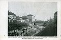
On the Vienna River during regulation

Model of the Magdalenengrund in the district museum Mariahilf (Anton Bienert)

From the postcard collection of the district museum (beggar's staircase)


Individual evidence
- ^ Austrian National Library: ANNO: Die Bühne, year 1937, issue 449, p. 8
Coordinates: 48 ° 12 ' N , 16 ° 21' E