Stephansplatz (Vienna)
| Stephansplatz | |
|---|---|
| Place in Vienna's inner city | |

|
|
| Basic data | |
| place | Vienna Inner City |
| District | Inner city |
| Confluent streets | Stock-im-Eisen-Platz , Graben , Goldschmiedgasse, Jasomirgottstraße, Brandstätte , Rotenturmstraße , Schulerstraße, Churhausgasse |
| Buildings | St. Stephen's Cathedral , Archbishop's Palace , Haas House , |
| use | |
| User groups | • Pedestrian traffic • Public transport ( subway U1 and U3 ; north side: buses 1A, 2A and 3A) • Car traffic (access is limited in time and to special groups) • Cycle traffic (officially not permitted) |
| Space design | Pedestrian zone (entire square, with the exception of the north-facing lane between Schulerstrasse and Rotenturmstrasse and the junction between Brandstätte and Rotenturmstrasse; one-way guidance in south-north and east-west direction) |
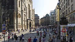
The Vienna Stephansplatz is both the urban as well as the geographical center of the Austrian federal capital . Within the first district ( Inner City ) and at the same time the historic city center , the square is off-center to the north ( Franz-Josefs-Kai / Donaukanal ) and east ( Stubenring ). In the middle of the square stands St. Stephen's Cathedral as a central element . The south-western corner of Stephansplatz and the eastern end of the blunt ditch and the northern end of Kärntner Straße are connected by Stock-im-Eisen-Platz, the northeast corner is connected to the beginning of Rotenturmstraße and the fire site. The western corner is bounded by the beginning of Schulerstraße, in the south-east the Churhausgasse joins next to the Archbishop's Churhaus .
Stephansplatz is located in front of the main entrance to the cathedral (giant gate ) at a height of 14.6 m above the Wiener Null , thus at 171.28 m above sea level. A. It rises slightly from Rotenturmstrasse (14.4 m) to Stock-im-Eisen-Platz (15.1 m), the highest point is on Churhausgasse at 15.4 m above sea level. W. N.
history

At the beginning of the construction of the later cathedral in the 12th century (consecration 1147), the church building site was outside the Vienna city walls . It was not until the city was expanded around 1200 that St. Stephan came under the protection of the wall. The following buildings can be proven to have been developed on Stephansplatz in the 13th century: a rectory, mentioned in 1222; a house of the protonotary, 1214; a chaplain's house, from 1214; a house owned by Zwettl Abbey in 1228; Karner, 1227; a house of the Teutonic Order , 1222; a priest house, verifiable until 1309; a school, verifiable since 1237.
At that time the church was surrounded by a cemetery. It and with it the square were affected by several city fires around the middle of the 13th century. The construction of the choir began at the beginning of the 14th century (1304 to 1340). From 1301 the Maria Magdalenenkapelle can be traced on Stephansplatz. Among other things, the Füchselhof was built in the 14th century, the Barleiherhaus and the Heiltumstuhl from 1483 in the 15th century .
Despite the permanent construction activity on the cathedral, Stephansplatz was a central place of communication for the city population, namely as a place of funerals , processions on high festive days (Easter, Whitsun, Christmas and All Saints' Day), passion plays , exhibitions, markets and probably also court trials. At that time the cemetery was apparently also a place for gambling , as the bans imposed by the sovereign testify. The medieval appearance of the square is difficult to reconstruct because of the numerous wooden frames associated with the cathedral. These paths can be reconstructed through the location of the cemetery gates and the positioning of the church portals.
The following gates existed as access to the old St.-Stephans-Freithof in the 15th century:
- the Messner Gate 1466
- the Leopold or Schulertor
- the Stephans or Hüttentor
- the tin gate 1466
Around 1500 the cathedral and cathedral square were already established as the center of the Habsburg residence and fortress city. The property on which the cathedral stands does not belong to Stephansplatz, but to the property of the cathedral itself. This property is legally independent ( factory property ). The owner of the Stephansplatz around the cathedral is the municipality of Vienna (public property: streets, squares, etc.).
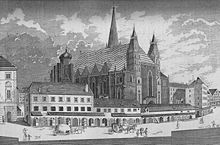
This function of Stephansplatz as the center of Vienna resulted in numerous redesigns in the following centuries, which were mainly carried out out of consideration for the requirements of transport and the service sector: The Heiltumsstuhl was demolished in 1699, and the one-story row of houses before the end of the 18th century Giant gate removed and the cemetery abandoned in 1732. The Magdalenenkapelle fell victim to a fire on September 12, 1781, while the Virgilkapelle below it was not rediscovered until 1973 when the underground was built. At the end of the 19th century, the entire square and its immediate surroundings underwent a fundamental historicist redesign with building densification. (Demolition of the area around the neighboring fire site , relocation of the building line at Stock-im-Eisen-Platz, removal of Schmidlin's house, etc.). In this context, Stephansplatz quickly became a center of retail trade, for example with the Rothberger department store and Anton Kranner's office building squeezed between its two buildings. Another push of centralizing development started after the destruction at the end of the Second World War . The fire in the cathedral in April 1945 started in the houses on Stephansplatz and spread to several others. The reconstruction took place - after an urban planning competition in 1946 - namely on the west side of the square in a modernized and further compressed form. The construction of the so-called Haas House after 1945 and in the 1980s led to special discussions . Overall, however, there was no strengthening of the retail function.
After the Viennese city planning around 1960, for example in Roland Rainer's traffic concept from 1961, was still opposed to an “excessive” promotion of the centrality of the inner city and thus an underground cross at St. Stephen's Cathedral, it came about in the mid-1960s a rethink. At the end of September 1965, the then City Councilor for Transport, Kurt Heller, presented the new general transport plan for Vienna, which prominently provided for that underground crossing. Since November 18, 1978, Stephansplatz has been connected to the U1 radial line of the Vienna subway , and since April 6, 1991 this north-south line has crossed here with the east-west line U3 . The section between the Karlsplatz and Stephansplatz stations is the busiest in the Vienna underground network. As the central junction of the underground and pedestrian zone , Stephansplatz is now the undisputed center of the Austrian capital.
The area of the square was completely renovated in the course of 2016 and 2017, the installations renewed and the paving newly laid. 14 cm thick granite slabs from Schrems in the Waldviertel were used. The size is 10,500 square meters. Lights in the shape of a lily of the valley are also installed, so that the style that was introduced in 2008 and 2009 in Kärntner Straße and Graben is consistently continued.
During the redesign in 2017, a transitional frieze made of small stones was placed around the cathedral itself and the areas in front of the main entrances to the cathedral were highlighted in color. The floor plan of the former Magdalenenkapelle, which had previously been traced with broad red stones in the pavement of Stephansplatz, is only marked with a narrow line of dark stones. In some niches on the walls of the cathedral, the paving was placed a little deeper in order to better accentuate the works of art and their bases in their original proportions. A skeleton of a young woman from the 18th century was found on the outer wall of the Magdalenenkapelle; there were no other remarkable archaeological finds during the redesign of the square.
Curhaus at Stephansplatz 3 and 3a
In the south-west of Stephansplatz is the Curhaus (also called Churhaus or Kurhaus ), bordered at the back by Singerstrasse. It was built in 1738–1740. Before that, after the consecration of St. Stephen's Church in 1147, there was the “parish school”. In 1296 Duke Albrecht I left this St. Stephen's School to the citizens of Vienna. In addition to this late medieval bourgeois school, the cathedral building hut of St. Stephan was also located here. In the 16th century the Jesuits took over the school and moved it, after which the house was used by the diocese.
Count Kollonitsch's cardinal coat of arms is attached to both doors . There are allegorical figures above the two portals; these represent the four theological disciplines of casuistry, liturgy, church history and biblical studies.
The courtyard at Stephansplatz 3 was converted into a lecture hall (called "Stephanisaal"). The 3rd floor is one of the locations of the Ecclesiastical Pedagogical University Vienna / Krems , the seat of the theological courses and the academy at the cathedral . The “Archbishop's Office for Teaching and Education” is on the 4th floor.
The Churhaus also forms an independent asset: the Chur- und Chorhaus zu St. Stefan. A third of this belongs to the assets of St. Stephen's Cathedral, the other two thirds belong to the "Archbishop's Chur in Vienna" and the Archdiocese of Vienna.
Bischofshof at Stephansplatz 7
The Bischofshof, known as the Archbishop's Palace since 1723 , is located in the north of Stephansplatz and has facades facing Stephansplatz, Rotenturmstraße and Wollzeile.
literature
- Exhibition catalog: Symbol and Mitte in Vienna 1147–1997 , p. 226. Special exhibition at the Historical Museum of the City of Vienna , Cathedral and Metropolitan Chapter Vienna, April 24 to August 31, 1997, Vienna 1997
Web links
- Stephansplatz in the Middle Ages ( Memento from July 28, 2004 in the Internet Archive )
- Everyday life in the Middle Ages - Stephansplatz
- Via the Virgil Chapel under Stephansplatz
Individual evidence
- ↑ Land register district court Innere Stadt Vienna , cadastral municipality 01004 Innere Stadt. Deposit number 1234, plots 817 and 818.
- ↑ Land register district court Innere Stadt Vienna, cadastral municipality 01004 Innere Stadt. Deposit number 1793, property 1711.
- ↑ Ring without tram - city center without bus. Vienna subway junction with the center Stephansplatz . In: Arbeiter-Zeitung . Vienna October 1, 1965, p. 1 ( berufer-zeitung.at - the open online archive - digitized).
- ↑ Waldviertler granite stones for Stephansplatz on ORF from April 12, 2017 accessed on April 13, 2017.
- ^ Groundbreaking ceremony for the new Stephansplatz orf.at, March 13, 2017, accessed March 13, 2017.
- ^ Wolfgang Zehetner: Annual report of the cathedral master builder. In: The Cathedral. Bulletin of the Vienna Cathedral Conservation Association. Episode 2/2017 ZDB -ID 1054178-0 . Pp. 6-7.
- ↑ THEOLOGICAL COURSES. Retrieved August 10, 2018 .
- ^ Cathedral parish: Curhaus
- ↑ Land register district court Innere Stadt Vienna, cadastral municipality 01004 Innere Stadt. Deposit number 1236, plot 823.
Coordinates: 48 ° 12 ′ 30.3 " N , 16 ° 22 ′ 20.9" E


