Masira
| Masira | ||
|---|---|---|
| Map of Masira | ||
| Waters | Arabian Sea | |
| Geographical location | 20 ° 22 ′ N , 58 ° 46 ′ E | |
|
|
||
| length | 95 km | |
| width | 14 km | |
| surface | 649 km² | |
| Highest elevation | Jebel Madrub 256 m |
|
| Residents | 8726 (December 12, 2010) 13 inhabitants / km² |
|
| main place | Ḥilf | |
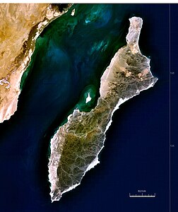
| Satellite image | ||
Masira ( Arabic مصيرة, DMG Maṣīra ; Latin: Zenobia (Roman name for the island in antiquity) is an island on the east coast of Oman . The 649 km² island is 95 km long and 12-14 km wide. The approximately 12,000 inhabitants of the island live for the most part in 12 places which are located on the north side of the island. Masira belongs administratively to the governorate Janub al-Sharqiyya and contains the southernmost territory of this region.
geography
The mountainous island has a very dry climate. Sand and stone deserts are characteristic. Significant elevations are the 256 m high Jabal Madrub and the 153 m high Jabal Suwair .
In the stony, about 10 m flat coastal areas, a halocline forms , which, due to its high nutrient content, forms the ideal habitat for corals , fish and turtles, such as the hybrid turtle . The beaches are home to the largest population of the loggerhead turtle , which lay their eggs here every year.
The Yemen dragon is native to the wadis of the island .
The pleasant climate between November and March alternates with the hot climate during the southeastern monsoons .
At the December 7, 2003 census, Masira had a population of 9,292. Of these, 8,872 or 95 percent lived in the main town of Ḥilf in the north of the island.
By the census on December 12, 2010, the population decreased to 8726, of which 8467 were in Ḥilf and 201 in Ghadayr.
Industry
The main industries on the island are fishing and the traditional textile industry. Traditional shipbuilding, on the other hand, has lost its importance.
In addition to a fish factory, the island's airport, which is also used by the Royal Air Force of Oman , is of further economic importance . In addition, some of the passenger traffic with the mainland is handled through it. There is also a small ferry to transport cars.
On the coasts of the island one can find the wrecks of unsuccessful dhows used by fishermen. These are well preserved due to the salty climate and the enormous heat.
tourism
The island has recently opened to tourism. However, the journey to Masira is still difficult. There is only one ferry connection several times a day with an irregular schedule. There is now a four-star hotel and a kite camp on the island. The island is an insider tip among kiteboarders due to the monsoon wind in summer, which blows constantly over the island at over 20 knots.
Military use
Masira was used as a military base by the British armed forces since the 1930s . After the end of World War II, the Americans stationed troops here instead of the British. In 2009 the base was finally taken over by the private security company DynCorp and, as before, serves as a replenishment and reconnaissance base.
Climate table
| Masirah | ||||||||||||||||||||||||||||||||||||||||||||||||
|---|---|---|---|---|---|---|---|---|---|---|---|---|---|---|---|---|---|---|---|---|---|---|---|---|---|---|---|---|---|---|---|---|---|---|---|---|---|---|---|---|---|---|---|---|---|---|---|---|
| Climate diagram | ||||||||||||||||||||||||||||||||||||||||||||||||
| ||||||||||||||||||||||||||||||||||||||||||||||||
|
Monthly average temperatures and rainfall for Masirah
|
|||||||||||||||||||||||||||||||||||||||||||||||||||||||||||||||||||||||||||||||||||||||||||||||||||||||||||||||||||||||||||||||||||||||||||||||||||||||||||||||||||||
swell
- Military History and geographical information (Engl.)
- Nautical map (English; PDF; 385 kB)
Individual evidence
- ^ Lionel Casson : The Periplus Maris Erythraei. Text, translation, and commentary . Princeton University Press, Princeton 1989, ISBN 0-691-04060-5 , p. 47.
- ↑ [1]
- ↑ Peter Carty: Oman's Desert Island . In: The Guardian (accessed January 5, 2014)
- ^ Riding the desert winds of the Masirah Island . In: surfertoday.com (accessed January 5, 2014)
literature
- John Gordon Lorimer: Gazetteer of the Persian Gulf. Vol. II. Geographical and Statistical. 1908, pp. 1176–1178 ( online)
- Gerald de Gaury: A Note on Masira Island . In: The Geographical Journal , Vol. 123 (1957), December, pp. 499-502, ISSN 0016-7398 ( introduction to JStor )


