Masnedø
| Masnedø | ||
|---|---|---|
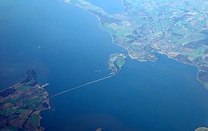
| Masnedø and Storstrømsbroen from the air | ||
| Waters | Baltic Sea | |
| Archipelago | Storstrømmen | |
| Geographical location | 54 ° 59 '10 " N , 11 ° 53' 10" E | |
|
|
||
| surface | 1.68 km² | |
| Residents | 161 (January 1, 2020) 96 inhabitants / km² |
|
Masnedø is a Danish island in Storstrømmen between Sjælland and Falster near Vordingborg .
The strait between Masnedø and Sjælland is called Masnedsund. The Storstrømsbroen connects Falster and Masnedø, the Masnedsundbroen Masnedø and Sjælland. The Ringsted – Rødby Færge railway and secondary route 153 between Zealand and Falster run across the island and over the two bridges . The island is 1.68 km² and has 161 inhabitants (January 1, 2020).
The island is part of the parish community ( Danish Sogn ) Vordingborg Sogn which to Danish municipal reform from 1970 to Harde Bårse Herred in the former præstø county gehörte- After that it belonged to vordingborg municipality in the former Storstrøms Amt that the next Danish municipal reform in 2007 extended the Vordingborg Municipality in the Sjælland region.
From 1912 to 1915 the Masnedø Fort was built on the island to secure the connection between Zealand and Falster. When Germany occupied Denmark on April 9, 1940, the world's first paratrooper attack took place here to take and secure the bridges. The fort was only guarded by three Danish soldiers and was not ready to fight. From 1952 the fort only served as a warehouse and in 1973 it was cleared by the military. Today it is open to the public and has hosted art exhibitions and a rock festival.

