McGrath (Alaska)
| McGrath | ||
|---|---|---|
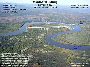
 McGrath aerial view |
||
| Location in Alaska | ||
|
|
||
| Basic data | ||
| State : | United States | |
| State : | Alaska | |
| Coordinates : | 62 ° 57 ′ N , 155 ° 35 ′ W | |
| Time zone : | Alaska ( UTC − 9 / −8 ) | |
| Residents : | 344 (as of 2014) | |
| Population density : | 2.8 inhabitants per km 2 | |
| Area : | 141.04 km 2 (approx. 54 mi 2 ) of which 122.51 km 2 (approx. 47 mi 2 ) is land |
|
| Height : | 101 m | |
| Postal code : | 99627 | |
| Area code : | +1 907 | |
| FIPS : | 02-46010 | |
| GNIS ID : | 1406131 | |
| Website : | www.mcgrathak.com | |
| Mayor : | Dustin Parker | |
McGrath is a place in the Yukon-Koyukuk Census Area in the US state of Alaska with the status City with 344 inhabitants (2014).
geography
McGrath is located at the confluence of the Takotna River in the Kuskokwim River . The distance to the southeastern Anchorage is 350 kilometers , to the northeastern Fairbanks 440 kilometers. The Denali National Park begins about 160 kilometers to the east.
history
The first settlers settled in the area in the early 1900s. In 1907, the place was named in honor of Peter McGrath, a US Marshal McGrath and created mainly on the northern side of the Kuskokwim River. After a major flood in 1933, most of the residents moved to the south side of the river. Since McGrath was the northernmost point of the Kuskokwim River, which was reached by large ships and in 1940 Federal Aviation Administration facilities and a runway for aircraft were built, the place developed into an important refueling stop for military equipment during of World War II .
Economy and transportation
McGrath functions today primarily as a transport, communication and supply center for the surrounding region. The place is increasingly being developed for tourism and visited by nature lovers, ornithologists , hunters and anglers. Moose sometimes appear on the outskirts or on the airport runway. During the summer months, McGrath is easily accessible by air or water. There is no paved trunk road, but there is an infrastructure of local roads. Winter trails are marked to Nikolai and Takotna , which can be traveled by snowmobiles or dog sleds . McGrath is also a checkpoint as part of the Iditarod , the world's longest dog sled race .
climate
The temperature fluctuates between 17 and 32 ° C in summer and between -57 and -18 ° C in winter. The annual average snowfall height is 2.2 meters. The river is usually ice-free between May and October.
Demographic data
In 2014 a population of 344 people was determined, which means a decrease of 14.2% compared to the year 2000. The average age of the residents in 2014 was 40.3 years, above the average for Alaska, which was 33.5 years. The proportion of inhabitants that can be traced back to the indigenous people was 31.7% at this point in time. These come mainly from the Aleutians , Yupik and Iñupiat as well as peoples with Athapaskan languages .
Individual evidence
- ↑ History ( Memento of the original from March 2, 2018 in the Internet Archive ) Info: The archive link was inserted automatically and has not yet been checked. Please check the original and archive link according to the instructions and then remove this notice.
- ↑ Iditarod section
- ↑ City data
Web links
- airport - McGrath Airport

