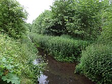
Meerbusch (forest area)
|
The sea bush
|
||
|
Information board |
||
| location |
|
|
| surface | 54 ha | |
| Identifier | NSG: NE-008 LSG: 4705-006 |
|
| WDPA ID | 162727 | |
| Geographical location | 51 ° 15 ' N , 6 ° 39' E | |
|
|
||
| Setup date | NSG: 1987 LSG: 1990 |
|
| administration | Rhine district of Neuss | |
The Meerbusch , also called Meerer Busch or Meererbusch , is a forest area in the south of the town of the same name, Meerbusch . Small parts are in the neighboring town of Kaarst .
A part of the Meerbusch with ecologically particularly valuable quarry forest forms the nature reserve "Der Meerbusch". The Meerbusch is also part of a landscape protection area.
Geographical location
The Meerbusch lies in the marshland on the left side of the Rhine in the area of a silted up old river channel , called Kendel on the Lower Rhine .
In the east, the Meerbusch borders on Büderich with Haus Meer , the districts of Alt-Meererbusch , Necklenbroich and Niederdonk and a golf course . In the north of Meerbusch goes into to Strümp associated Strümper Busch over. In the northwest is Osterath with the district Bovert . To the west of the Meerbusch lies the Broicher side district, part of Kaarst, with a few individual farms . There is also a gravel mining area with several quarry ponds , which is cut through by the A57 .
The western part of the Meerbusch is a wetland through which the Meerscher Mühlenbach (so called because it used to drive a water mill in Haus Meer) flows from south to north . The Mühlenbach comes from the direction of the Lauvenburg , unites at the southern edge of the Meerbusch with the Schackumer Bach coming from Haus Schackum , a little further north of the border ditch (dry) coming from the northwestern forest area east of Bovert (BK-4705-017 ) and leaves the Meerbusch on the northern edge towards Strümper Busch .
Location overview:
|
Bovert (to Osterath ) |
L26, K-Bahn , Strümper Busch (to Strümp ) |
Haus Meer , Alt-Meererbusch (to Büderich ) |
| A57, Baggerseen Broicher Feld |

|
Büderich with the Schackum House |
| Broicherseite (to Kaarst) Gut Mankartzhof |
L30, Lauvenburg (to Kaarst) |
Necklenbroich, Niederdonk, golf course (to Büderich) |
Name and story
The Meerbusch (Meerer Busch) takes its name from the former noble seat and monastery Haus Meer , east of the forest , to whose lands the forest historically belonged. Its name is derived from the Lower Rhine word sea , which denotes a wetland.
The Gartenstadt Meererbusch settlement to the west of the forest and ultimately the city of Meerbusch , founded in 1970, were named after the Meerer Busch .
Biotope and protected area
In the humid lowlands on the southern and western edge of the Meerbusch, along the course of the Schackumer Bach and Mühlenbach , an intact alder quarry forest with a few isolated bodies of water, sedges and reeds has formed. These areas provide habitat for a variety of moisture-loving animals and plants, especially some rare bird and amphibian species. A transition zone of willow, poplar and ash forest, interspersed with shrubs and herbs, adjoins to the east. In the biotope cadastre, the forest area is divided into
- the NSG Meerbusch (object identifier BK-4705-902, wet forest along the Mühlenbach),
- the LSG Meerbusch (BK-4705-018, the core area, under forest use) and
- the NSG Schackumer Bachtal (BK-4705-904, wet and damp meadows along the former course of the Schackumer Bach).
Some open, extensively used pasture and arable land are also part of the nature reserve. The eastern, not protected areas of the gulf consist mainly of beech and pedunculate oak.
Since 1990, the Meerbusch has been integrated into the approximately 600 hectare Strümper Busch, Meerbusch, Stinkesbachaue landscape protection area due to its location in the historically significant Altrheinrinne .
Web links
Individual evidence
- ↑ a b The District Administrator of the Rhein-Kreis Neuss (ed.): EC Water Framework Directive (WFD). Implementation timetable of the cooperation Left Rhine tributaries Neuss-Uerdingen (PE_RHE_1200) . Office for Environmental Protection, Lower Water Authority, Grevenbroich March 2012 ( full text (PDF)).
- ↑ a b c nature reserve “Der Meerbusch” in the specialist information system of the State Office for Nature, Environment and Consumer Protection North Rhine-Westphalia , accessed on March 8, 2017.
- ↑ a b c LSG-Struemper Busch, Meerbusch, Stinkesbachaue. European Environment Agency, archived from the original on January 6, 2013 ; Retrieved June 12, 2012 .
- ↑ a b House Sea. (No longer available online.) City of Meerbusch, archived from the original on June 20, 2012 ; Retrieved June 12, 2012 . Info: The archive link was inserted automatically and has not yet been checked. Please check the original and archive link according to the instructions and then remove this notice.
- ↑ The Meerbusch nature reserve. (No longer available online.) House of Nature - Biological Station in the Rhein-Kreis Neuss e. V., archived from the original on May 10, 2013 ; Retrieved June 12, 2012 . Info: The archive link was inserted automatically and has not yet been checked. Please check the original and archive link according to the instructions and then remove this notice.
- ↑ a b World Database on Protected Areas - LSG Strümper Busch, Meerbusch, Stingesbachaue (English)
- ↑ Entry BK-4705-017 (forest area east of Bovert) in the biotope register of the LANUV NRW


