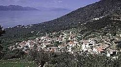
Megalochori (Methana)
|
Local community Megalochori Τοπική Κοινότητα Μεγαλοχωρίου (Μεγαλοχώρι) |
||
|---|---|---|
|
|
||
| Basic data | ||
| Country |
|
|
| region | Attica | |
| Regional district | Islands | |
| local community | Trizinia-Methana | |
| Parish | Methana | |
| Geographic coordinates | 37 ° 36 ' N , 23 ° 21' E | |
| Height above d. M. |
55 m below sea level (village) |
|
| surface | 16.006 km² | |
| Residents | 290 (2011) | |
| Population density | 18.00 km² | |
| LAU-1 code no. | 52080204 | |
| Local division | 4th | |
| Post Code | 180 30 | |
| Telephone code | 022980 | |
| Megalochori on Methana | ||
Megalochori ( Greek Μεγαλοχώρι ( n. Sg. ); Dt. 'Large village') is a village on the Attic peninsula of Methana . Together with three other small settlements, it forms a local community of the same name.
Below the village is the acropolis of ancient Methana, which was also described by Pausanias . The village used to have the Albanian name Katoundi Imath, which also means 'big village'.
Residents
| year | Residents |
|---|---|
| 1981 | 437 |
| 1991 | 226 |
Individual evidence
- ↑ Results of the 2011 census at the National Statistical Service of Greece (ΕΛ.ΣΤΑΤ) ( Memento from June 27, 2015 in the Internet Archive ) (Excel document, 2.6 MB)

