Melendiz Çayı
|
Melendiz Çayı Uluırmak |
||
|
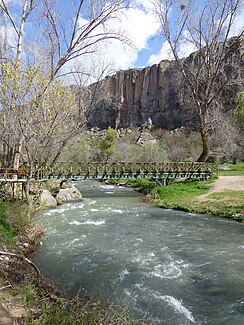
Melendiz Çayı in the Ihlara Valley |
||
| Data | ||
| location | Aksaray , Niğde ( Turkey ) | |
| River system | Melendiz Çayı | |
| source | on the northern slope of Melendiz Dağı 38 ° 4 ′ 17 ″ N , 34 ° 32 ′ 37 ″ E |
|
| Source height | approx. 2800 m | |
| muzzle | Lake Tuz Gölü Coordinates: 38 ° 35 ′ 18 ″ N , 33 ° 42 ′ 16 ″ E 38 ° 35 ′ 18 ″ N , 33 ° 42 ′ 16 ″ E |
|
| Mouth height | 925 m | |
| Height difference | approx. 1875 m | |
| Bottom slope | approx. 16 ‰ | |
| length | approx. 120 km | |
| Right tributaries | Aksu Çayı | |
| Reservoirs flowed through | Mamasın Dam | |
| Big cities | Aksaray | |
| Small towns | Çiftlik | |
| Communities | Ilısu, Ihlara, Yaprakhisar, Selime, Kızılkaya, Doğantarla, Gücünkaya | |
The Melendiz Çayı (also Uluırmak ) is a river in Central Anatolia .
The Melendiz Çayı rises on the northern slope of the Melendiz Dağı in the northwest of the Niğde province . Initially it flows north. He passes the district town of Çiftlik and then turns west. In the province of Aksaray it passes the places Ilısu and Ihlara. The river then flows through the gorge of the Ihlara valley in a north-northwest direction. The villages of Yaprakhisar, Selime , Kızılkaya and Doğantarla are located on the middle course of the river. This is dammed by the Mamasın dam near Gücünkaya . The Aksu Çayı , a right tributary, also flows into the reservoir. About 10 km west of the dam is the provincial capital Aksaray , which the Melendiz Çayı flows through. Most of the river water is drained through canals for irrigation purposes. At its confluence with the Tuz Gölü salt lake , about 40 km northwest of Aksaray, the Melendiz Çayı is just a trickle. The Melendiz Çayı has a length of about 120 km.
