Mentschul
|
Mentschul Менчул |
||
|---|---|---|
|
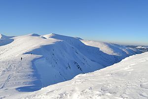
The mentschul in winter |
||
| height | 1998 m | |
| location |
Zakarpattia Oblast , Ivano-Frankivsk Oblast , Ukraine |
|
| Mountains | Carpathian Mountains , Chornohora | |
| Coordinates | 48 ° 5 '30 " N , 24 ° 35' 46" E | |
|
|
||
| rock | Flysch | |
The Mentschul ( Ukrainian Менчул , Russian Мунчель Muntschel , Polish Munczeł ) is a 1998 m high mountain in the southeastern part of the ridge of the " Black Mountains ", the highest mountain range of the Forest Carpathians in Ukraine .
The mountain lies between the 1878 m high Dzembronja in the southeast and the 2036 m high Brebeneskul in the northwest on the border of the Transcarpathian Oblast and the Ivano-Frankivsk Oblast .
Since the 1998 meter high mountain is still two meters short to count as 2000 , a group of activists wanted to build an artificial hill on top of the mountain in 2009 to raise it to 2000 meters.
Web links
Commons : Mentschul - collection of images, videos and audio files
- Ukrainian 2000s and Mentschul (Ukrainian)
Individual evidence
- ^ Institute for Natural Sciences, Geography and Natural History - The highest peaks of the Ukrainian Carpathians and their geomorphological regions ; accessed on April 24, 2017 (Ukrainian)
- ↑ Berg Mentschul on igotoworld.com ; accessed on April 24, 2017 (Ukrainian)


