Merkinė
Merkinė is an urban settlement in the Rajong municipality of Varėna , in southwest Lithuania , at the confluence of the Memel and Merkys rivers in the Dzūkija National Park.
Although it is larger than many cities ( miestai ) in Lithuania with 1,434 inhabitants , it is only classified as a small town (lit. miestelis ). Since there are only 60 large self-governing municipalities in Lithuania, the small town of Merkinė, like most other towns in Lithuania, is no longer a regional authority, but only the capital of the rural district Merkinė ( seniūnija ) of the Rajong municipality Varėna, which is three times its population .
The place on the historical route Warsaw - Vilnius is the place of death of the Polish king Władysław IV. Wasa ( 1648 ).
Mass graves of Jews murdered in World War II have been found in the nearby forests .
history
In 1359 a wooden castle on the Memel was mentioned in a document, the remains of which can still be seen today. Here are German knights who fought against Lithuanians.
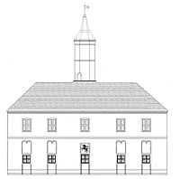
In 1556 Merkinė received Magdeburg city rights . These were certified by Sigismund II August in 1569 . In 1595 the Merkinė Town Hall , which was built on the town square, was first mentioned in a document. The Church of the Assumption of Mary was built in 1615 and was hit by a cannonball that is still stuck in the wall during the Thirty Years' War .
A Dominican church was built in the early 17th century . From 1773 to 1775, the Merkinė state authorities moved to Alytus . Merkinė was under self-government until 1776. This was then suspended until 1791, when Merkine became independent again for five years.
In 1960 the Merkinė Secondary School was established. In 2003 a pyramid was built in Česukai , 1 km south of Merkinė.
Jews
Jewish traces can be traced back to 1539 when there was a dispute between a Jewish and a Christian man. In 1551 the Jews of Merkinė were exempted from the special tax ("Serebschizna"). In the 19th century some Jewish scholars such as Mordecai Melzer, Isaac b. Elijah Margolis and his son Max Margolis, from the town.
On June 23, 1941, shortly after the Wehrmacht invaded Lithuania, the German troops also reached Merkinė. The persecution of the Jews began there almost at the same time. But the German troops also hunted partisans and communists. Officially, all those persecuted were killed in labor camps or the prison in Alytus , but in reality shortly after they were removed. In September 1941, all the Jews in the village were rounded up by B. Naujokas, the Merkinė police chief, and held in a synagogue and in the Jewish school. About 700 people from the surrounding area, including from Leipalingis , Seirijai and Liškiava , were also brought to Merkinė by German soldiers and Lithuanian auxiliary workers, the so-called white armbands.
On September 10, 1941, all prisoners, according to official information from the Jäger report, 854 Jews, including 355 women and 276 children, were murdered by members of the SS and Lithuanian auxiliaries, the so-called Einsatzkommando 3 . Today a memorial plaque ( 54 ° 9 ′ 27.7 ″ N , 24 ° 11 ′ 33 ″ E ) near the Jewish cemetery ( 54 ° 9 ′ 36.7 ″ N , 24 ° 11 ′ 31.5 ″ E ) commemorates of the massacre that took place there.
Buildings
- Merkinė Bridge
- Castle hill at the confluence of the Merkys and Nemunas rivers
- Jewish Cemetery
- Assumption of Mary Church from 1615
- Merkinė City Hall
people
- Władysław IV. Wasa (1595–1648), King of Poland, place of death and vacation
- Max Leopold Margolis (1866–1932), American philologist
- Aleksandras Čyras (1927–2001), civil engineer and professor
- Arvydas Bajoras (* 1956), politician
swell
- ↑ a b c Merkine. In: alles-ueber-litauen.de. Retrieved on May 21, 2018 (German).
- ↑ Merkinė
- ^ Herman Rosenthal and AS Waldstein: Merech . In: Isidore Singer et al. (Ed.): Jewish Encyclopedia. Funk & Wagnalls Company., New York ( jewishencyclopedia.com ).
- ^ A b Mass Murder of the Jews of Merkinė. In: Holocaust Atlas of Lithuania. Retrieved May 21, 2018 .
- ↑ Merkinės žydų žudynių ir užkasimo vieta. In: kvr.kpd.lt. Retrieved May 21, 2018 (Lithuanian).
- ↑ LLTA Lauku Celotajs: Merkinė. Retrieved May 21, 2018 .
Web links
Coordinates: 54 ° 10 ′ N , 24 ° 11 ′ E


