
Meuchelberg
| Meuchelberg | ||
|---|---|---|
 Meuchelberg |
||
| height | 372.9 m above sea level NHN | |
| location | at Heimbach ; District of Düren , North Rhine-Westphalia ( Germany ) | |
| Mountains | Rureifel ( Eifel ) | |
| Coordinates | 50 ° 37 '53 " N , 6 ° 28' 20" E | |
|
||

The Meuchelberg in the south of the city of Heimbach in the North Rhine-Westphalian district of Düren is 372.9 m above sea level. NHN high Umlaufberg of the Rureifel in the northern part of the Eifel . Legend has it that the mountain is named after a quarrel between two brothers who are said to have killed each other.
geography
location
The Meuchelberg is located in the Rureifel in the Hohes Venn-Eifel nature park in the Heimbach city area. As a circulating mountain , it is washed around the north, east and south like a peninsula by a loop of the river Rur . In the west and north, the elevation connects directly to the Heimbach urban area and can be accessed from there via several entrances. In the eastern part of the Meuchelberg, in the Rurschleife, is the city's spa park , which is encompassed by the street Über Rur and connected to the city area by a bridge over the Rur. This is connected to the Am Meuchelberg road in the west via hiking trails on the Meuchelberg . From the north you can take the Schönblick path to the area, which begins directly behind the community elementary school and the forest cemetery. There are also several viewpoints on the slopes from which the town and the Rur can be observed.
The Meuchelberg falls sharply towards the Rur. The slopes above the Rur are characterized in places by pronounced slate rocks . In the south is the Heimbach reservoir .
Natural allocation
The Meuchelberg belongs to the natural spatial main unit group Westeifel / Ardennen (No. 28), in the main unit Rureifel (282) and in the subunit Rur-Urft-Olef-Täler (282.3) to the Heimbach-Maubacher Rurtal natural area (282.34).
Protected areas

Most of the Meuchelberg is part of the Düren district landscape protection area (sub-area 1) ( CDDA no. 322307; 1988; 307.29 km² ). It also forms the largest part of the Meuchelberg nature reserve and south-exposed slopes on the Heimbach reservoir with a total area of 69.7 hectares. Due to the special geological and topographical properties of the Meuchelberg, valuable habitats such as rocks, heaths, hillside rubble forests and dry, warm oak forests have developed here. In the Ruraue at the foot of the mountain, there are also species-rich oat meadows on extensively used grassland.
The protection grounds of the area are diverse and relate to the protection of the geomorphology as well as that of the soils and the ecosystems . One of the main reasons is the preservation and restoration of the quartzite - slate- rock ecosystem with biotopes protected in North Rhine-Westphalia and the creation of the biotope network in the Eifel. In addition, the preservation and restoration of the habitat of several animal and plant species endangered according to the Red List in North Rhine-Westphalia, the preservation of the soils worthy of protection with their extreme water or nutrient offers and the preservation of the geologically and geomorphologically significant rocks and quarries from scientific, Natural history, geographical and geological reasons given as protection reasons. In addition, there is the preservation of the valley slopes of the Rur valley, which are characterized by steep rock formations, because of their rarity, special scenic beauty and uniqueness.
The region and the Meuchelberg itself are of particular importance for the preservation, restoration and development as a habitat and habitat and for the protection of bird species of European importance according to the Birds Directive (Directive 79/409 / EEC) and the designation as a protected area according to the Habitats Directive to maintain multiple habitat types. The nature reserve includes dry heathland, lean flatland hay meadows as well as silicate rocks with crevice vegetation and pioneer vegetation, which are considered particularly worthy of protection. In addition, in the area with the wall lizard ( Podarcis muralis ), the Spanish flag ( Euplagia quadripunctaria ) and the steppe grasshopper ( Chorthippus vagans ), several priority and particularly protected species according to the Habitats Directive have been identified.

Slate on Meuchelberg
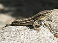
Wall lizard ( Podarcis muralis )
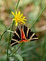
Spanish flag ( Euplagia quadripunctaria )
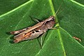
Steppe grasshopper ( Chorthippus vagans )


_8056048-PSD.jpg)

Traffic and walking

State road 218, which runs from Vlatten through Heimbach to Hasenfeld, runs through Heimbach and north of the Meuchelberg along the Rur . To Meuchelberg itself, the street Am Meuchelberg leads from the west and the Schönblick from the north along the forest cemetery. To the east, the area is connected via the Kurpark and the Ringweg Über Rur . There are several hiking trails on the Meuchelberg itself (hiking trail 29).
Individual evidence
- ↑ a b c Map services of the Federal Agency for Nature Conservation ( information )
- ↑ a b Meuchelberg on rureifel-tourismus.de; accessed on July 4, 2020.
- ↑ a b c nature reserve Meuchelberg and south-exposed slopes at the Heimbach reservoir (DN-042) on naturschutzinformationen.nrw.de; accessed on July 4, 2020.
- ↑ Meuchelberg on naturschutzinformationen.nrw.de; accessed on July 4, 2020.
Web links
- Meuchelberg nature reserve and south-facing slopes at Heimbach reservoir (DN-042) on naturschutzinformationen.nrw.de