Vlatten (Heimbach)
|
Vlatten
City of Heimbach
Coordinates: 50 ° 38 ′ 59 ″ N , 6 ° 32 ′ 53 ″ E
|
|
|---|---|
| Height : | 280 (275-330) m above sea level NHN |
| Area : | 7.8 km² |
| Residents : | 897 (Jul 31, 2017) |
| Population density : | 115 inhabitants / km² |
| Incorporation : | 1st July 1969 |
| Postal code : | 52396 |
| Area code : | 02425 |
|
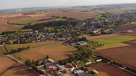
Vlatten, aerial photo (2015)
|
|
Vlatten is a district of the town of Heimbach in the Düren district .
location
Vlatten is nestled in a gentle valley of the Voreifel on the eastern outskirts of Heimbach. Next to Vlatten are Wollersheim , Hergarten and Heimbach.
history
The first settlements took place in Roman times . It was first mentioned in 869. The place name "Vlatten" is probably already of Celtic origin (from Vlatos = the ruler).
At the time of the Franks , Vlatten was a royal palace . Around 1200 there were two castles in Vlatten. The upper castle was first mentioned in a document in 1385. At the end of the 14th century, the lower castle was created from another permanent courtyard, probably through an inheritance. Like the upper castle, it was a moated castle. The lower castle, built on swampy terrain, fell into disrepair over the centuries. Only an overgrown cairn can be seen of it.
Churches
The church is documented until 839. At that time, a chapel belonged to the royal palace , from which the church emerged. Around 1000 the church was the center of the royal court. In the following centuries further construction work took place on the church, and in 1927/28 the north aisle was added.
A chapel from the 13th century is documented. Of this only the choir vault with old wall paintings remains . The ship and tower were built in 1212/13, while today's ship with the tower was rebuilt in a smaller version than the original chapel.
school
The school in Vlatten, which is in the center of the village, is no longer used as a school facility. It was converted into an apartment building.
Reorganization
The municipality of Vlatten has belonged to the Bleibuir mayor since the 19th century, which in 1928 became the Bleibuir office. Since 1949 Vlatten belonged to the Hergarten office, which also consisted of the communities Hergarten, Berg , Floisdorf , Eicks , Glehn , Hostel and Bleibuir . Until the local reorganization, Vlatten was an independent municipality. On July 1, 1969, it merged with the city of Heimbach.
The city of Heimbach and all its districts came from the Schleiden district to the Düren district on January 1, 1972 and was incorporated into the city of Nideggen . On August 4, 1972, the Higher Administrative Court in Münster decided that Heimbach should become an independent municipality again. Vlatten remained assigned to Heimbach.
traffic
The federal highway 265 runs past Vlatten . There is no through traffic in the place. Local public transport is ensured by BVR bus line 231 .
economy
The main livelihoods of the residents are a large number of small commercial businesses. Many Vlatteners work outside the village. The influence of agriculture as the main livelihood has decreased significantly in the last 20 years, but still makes up a significant part of it compared to many other places of this size.
Personalities
- Ulrike Schwieren-Höger (* 1951), author living in Vlatten
- Herbert Brockel (* 1965), cook born in Vlatten
Others
- In 1997 Vlatten was able to win a silver medal in the competition " Our village has a future " at district level and in 2006 and 2012 also a silver medal at state level. In this competition at the district level, Vlatten won a gold medal in 2008. In 2012, the special award from the NRW Foundation for large, well-tended nature reserves and numerous old and new orchards was added. In 2018 Vlatten won a silver medal at the state level
- From 1922 to 1926 the Eifelrennen ran through the town.
- The water castle route cycle path leads through the village . This connects more than 130 castles on the edge of the Eifel and in the Cologne Bay .
Individual evidence
- ^ Territorial.de: Mayor offices and communities in Schleiden district
- ↑ GenWiki: Amt Bleibuir
- ^ City archive Mechernich: Findbuch Hergarten
- ↑ Martin Bünermann: The communities of the first reorganization program in North Rhine-Westphalia . Deutscher Gemeindeverlag, Cologne 1970, p. 100 .
- ↑ a b Federal Statistical Office (ed.): Historical municipality register for the Federal Republic of Germany. Name, border and key number changes in municipalities, counties and administrative districts from May 27, 1970 to December 31, 1982 . W. Kohlhammer, Stuttgart / Mainz 1983, ISBN 3-17-003263-1 , p. 306 f .
- ↑ https://www.radiorur.de/rur/rr/1520763/news/kreis_dueren


