
Mielec (rural municipality)
| Gmina Mielec | |||
|---|---|---|---|

|
|
||
| Basic data | |||
| State : | Poland | ||
| Voivodeship : | Subcarpathian | ||
| Powiat : | Mielec | ||
| Geographic location : | 50 ° 18 ′ N , 21 ° 28 ′ E | ||
| Residents : | see Gmina | ||
| Postal code : | 39-300 | ||
| Telephone code : | (+48) 17 | ||
| License plate : | RMI | ||
| Economy and Transport | |||
| Next international airport : | Rzeszów-Jasionka | ||
| Gmina | |||
| Gminatype: | Rural community | ||
| Gmina structure: | 13 towns | ||
| 13 school authorities | |||
| Surface: | 122.72 km² | ||
| Residents: | 13,352 (June 30, 2019) |
||
| Population density : | 109 inhabitants / km² | ||
| Community number ( GUS ): | 1811052 | ||
| administration | |||
| Wójt : | Józef Piątek | ||
| Address: | ul. Jadernych 7 39-300 Mielec |
||
| Website : | www.gmina.mielec.pl | ||

The Gmina wiejska Mielec is a rural municipality in the powiat Mielec of the Subcarpathian Voivodeship in Poland . The seat of the municipality is the city of Mielec , which, however, does not belong to the Gmina. The Gmina has an area of 122.7 km² and 13,352 inhabitants (as of June 30, 2019).
Administrative history
From 1975 to 1998 the rural community belonged to the Rzeszów Voivodeship .
structure
The following 13 localities with a Schulzenamt ( sołectwo ) belong to the rural community of Mielec :
- Boża Wola
- Chorzelów
- Chrząstów
- Goleszów
- Książnice
- Podleszany
- Rydzów
- Rzędzianowice
- Szydłowiec
- Trześń
- Wola Chorzelowska
- Wola Mielecka
- Zlotniki
Architectural monuments
- Church in Chorzelów
- 17th century rectory in Chorzelów
- Burial chapel of the rectory in Chorzelów
- Castle ruins in Dąbrówka Starzeńska
- Pictures of the architectural monuments
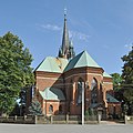
Church in Chorzelów

Rectory in Chorzelów

Chorzelów cemetery

Chapel in Podleszany


Web links
Commons : Gmina Mielec - collection of images, videos and audio files
- Rural Municipality Website (Polish)
Individual evidence
- ↑ population. Size and Structure by Territorial Division. As of June 30, 2019. Główny Urząd Statystyczny (GUS) (PDF files; 0.99 MiB), accessed December 24, 2019 .