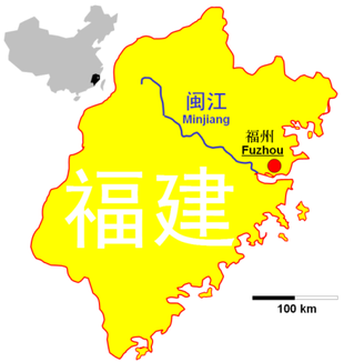
Min Jiang (Fujian)
| Min Jiang | ||
|
Location of Min Jiang in Fujian |
||
| Data | ||
| location | Fujian ( PR China ) | |
| River system | Min Jiang | |
| Confluence of |
Wuyi Mountains , confluence of the Xi Xi and Jian Xi rivers near the core city of Nanping 26 ° 38 ′ 8 ″ N , 118 ° 11 ′ 1 ″ E |
|
| muzzle | near Fuzhou in the East China Sea Coordinates: 26 ° 3 ′ 32 " N , 119 ° 40 ′ 57" E, 26 ° 3 ′ 32 " N , 119 ° 40 ′ 57" E |
|
| Mouth height |
0 m
|
|
| length | 541 km | |
| Catchment area | 60,992 km² | |
| Big cities | Nanping , Fuzhou | |
|
Min Jiang in Nanping |
||
|
Min Jiang in Fuzhou |
||
The Min Jiang ( Chinese 闽江 , Pinyin Mǐn Jiāng ) is the largest of the more than 600 rivers in the Chinese province of Fujian .
geography
The Min rises in the Wuyi Mountains , which form the watershed between the two provinces of Fujian and Jiangxi . It flows through the province over a length of 541 kilometers and drains a territory of 60,992 km². Its gradient is 0.5 per thousand.
The Min is fed by three major tributaries, the Jian Xi , Futun Xi and Sha Xi , which, due to the geography of Fujian, make up about 70% of the catchment area of the Min River. Of these three rivers, the Jian Xi has the largest catchment area. 91% of the catchment area is above the town of Jianping .
The Min drains much of Fujian Province and, like most of the province's rivers, runs across the mountain ranges from northwest to southeast. It discharges 57.4 billion cubic meters of water into the sea every year, which is almost half of the total runoff in Fujian Province. Thus, it represents the only natural connection between the coast and the interior. However, it is only navigable for short distances inland for large ships.
At the measuring point near Zhuqi in Minhou County , an annual average of 1,750 cubic meters of water flowed off per second. The highest value so far was determined in 1937 with 2670 cubic meters per second, the lowest value with 850 cubic meters per second in 1971. Three quarters of the water flows away in the spring and summer months. In June, 22.6% of the total annual volume flows through the measuring point, compared to 2.8% in January.
Surname
The Min River is also namesake for the province of Fujian, whose short name is Min ( Chinese 閩 / 闽 ) and for the predominant Min dialects (Minyu 闽语) in Fujian and Taiwan .
Quote
“ At the first main Fuzhou, the river Min flows, which has its origin on the border with Zhejiang Province , and then flows past the cities of Pucheng 浦城, Yanping 延平 and Shuikou 水口. Beyond the cities, however, it becomes very abundant in water, smuggles forcibly into the region of this capital, and finally falls into the sea. From the city of Pucheng to the city of Shuikou it rushes strongly and quickly through the valleys and stone cliffs, after which it begins to flow gently. And however strong it may flow, the Chinese, because of their innate astuteness and wonderful craftsmanship, navigate it in very small ships. Which not only have a single rudder like other ships, but two, namely one at the front and one at the rear. With these steering sticks you know how to rule these little ships like with the bridle of a horse and to guide them nimbly and swiftly through the cliffs lying both below and above the water. "
Tributaries
- Sha River (沙溪)
- Futun Xi (富屯溪)
- Chongyang Xi (崇阳 溪)
- Jian River (建 溪)
- Song River (松溪)
- Nanpu River (南浦 溪)
- You River (Fujian) (尤溪)
- Dazhang River (大 樟 溪)
literature
- Siegfried Englert : The Fujian Province in the PR China . Annweiler: Plöger, 2013. ISBN 978-3-89857-289-7
Web links
Individual evidence
- ↑ a b c 刘学沛: 福建省 志 地理 志 . 1st edition. 方志 出版社, 北京 2001, ISBN 7-80122-612-7 , pp. 93 (Chinese).
- ↑ 刘学沛: 福建省 志 地理 志 . 1st edition. 方志 出版社, 北京 2001, ISBN 7-80122-612-7 , pp. 94 (Chinese).
- ↑ a b 刘学沛: 福建省 志 地理 志 . 1st edition. 方志 出版社, 北京 2001, ISBN 7-80122-612-7 , pp. 96 (Chinese).
- ↑ 刘学沛: 福建省 志 地理 志 . 1st edition. 方志 出版社, 北京 2001, ISBN 7-80122-612-7 , pp. 97 (Chinese).
- ^ Johan Neuhof from the county of Bentheim in today's Lower Saxony (* 1618 - † 1672) In the years 1655 - 1657 as the Dutch envoy in China. Quoted from Siegfried Englert : The Fujian Province in the PR China . Annweiler: Plöger, 2013. ISBN 978-3-89857-289-7


