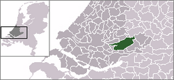
Molenwaard
 flag |
 coat of arms |
| province |
|
| local community | Molenlanden |
|
Area - land - water |
126.48 km 2 118.28 km 2 8.2 km 2 |
| Residents | 29,297 (Sep. 30, 2018) |
| Coordinates | 51 ° 52 ' N , 4 ° 47' E |
| Important traffic route |
|
| prefix | 0184 |
| Postcodes | 2957, 2959, 2961, 2964-2965, 2967-2969, 2971, 2973-2975, 2977, 3366 |
| Website | Homepage of Molenwaard |
Molenwaard was a municipality in the Dutch province of South Holland that was created on January 1, 2013 from the merger of the municipalities of Graafstroom , Liesveld and Nieuw-Lekkerland and merged with Giessenlanden to form the new municipality of Molenlanden on January 1, 2019 .
politics
fusion
On January 1st, 2019, Molenwaard merged with Giessenlanden to form the new municipality of Molenlanden .
Distribution of seats in the municipal council
The local elections on November 21, 2012 resulted in the following distribution of seats:
| Political party | Seats |
|---|---|
| 2012 | |
| SGP | 5 |
| CDA | 5 |
| ChristenUnie | 4th |
| PvdA | 3 |
| Community affairs Molenwaard | 2 |
| VVD | 2 |
| total |
Due to the merger on January 1, 2019, the elections for the council of the new municipality of Molenlanden took place on November 21, 2018.
mayor
From the foundation of the congregation to the dissolution of the congregation, Dirk van der Borg ( CDA ) was initially in office as provisional mayor from September 4, 2013. His colleagues include the councilors Piet Vat ( SGP ), Frank Meerkerk (CDA), Kees Boender ( ChristenUnie ), Paul Verschoor ( PvdA ) and the community secretary Bas Nootenboom .
Political structure
The community was divided into the following districts:
| No. | place | Residents |
|---|---|---|
| 00 | Nieuw-Lekkerland | 9,270 |
| 01 | Bleskensgraaf | 2,910 |
| 02 | Brandwijk | 1,305 |
| 03 | Goudriaan | 920 |
| 04 | Molenaarsgraaf | 1,140 |
| 05 | Ottoland | 970 |
| 06 | Oud-Alblas | 2,180 |
| 07 | Wijngaarden | 685 |
| 08 | Groot-Ammers | 4,220 |
| 09 | Langerak | 1,715 |
| 10 | Nieuwpoort | 1,435 |
| 11 | Streefkerk | 2,480 |
| local community | 29,212 | |
Sons and daughters of the church
- Gerard Marius Kam (1836–1922), born in Oud-Alblas, entrepreneur , local politician , local researcher and collector, as well as founder of the former Rijksmuseum Kam in Nijmegen, named after him
Web links
Individual evidence
- ↑ Bevolkingsontwikkeling; regio per maand . In: StatLine . Centraal Bureau voor de Statistiek , accessed January 1, 2019 (Dutch)
- ↑ Molenlanden nieuwe naam gemeenten Giessenlanden en Molenwaard. In: Het Kontakt Alblasserwaard. September 25, 2017, accessed May 30, 2018 (Dutch).
- ↑ a b Result of the local elections , accessed on June 5, 2018 (Dutch)
- ↑ Herindelingen Kiesraad , accessed on May 30, 2018 (Dutch)
- ↑ Dirk van der Borg voorbedagen as burgemeester van Molenwaard. In: Nederlands Genootschap van Burgemeesters. Retrieved June 5, 2018 (Dutch).
- ↑ College en besluiten Molenwaard Gemeente Molenwaard, accessed June 5, 2018 (Dutch)
- ↑ Kerncijfers wijken en buurten 2017 Centraal Bureau voor de Statistiek , accessed on June 5, 2018 (Dutch)
