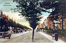
Moltkestrasse (Lübeck)
The Moltke Street is an avenue in the district St. Jürgen in the Hanseatic city of Lübeck . The development from the Wilhelminian era is under ensemble protection due to its unity .
location
Moltkestrasse is an extension of Wahmstrasse and Krähenstrasse on the old town island and provides access to the historic core of Lübeck. It starts at Hüxtertorallee and leads out of town via Wakenitz to Moltkeplatz. It thus forms the access to Brandenbaum to the east and connects to Mecklenburg to the northeast via Schlutup and to the southeast via Herrnburg . Moltkestrasse is the southern border of the medieval falcon field.
history
The name of the street is reminiscent of Lübeck's honorary citizen General Field Marshal Helmuth Karl Bernhard von Moltke . Moltkestrasse was laid out in 1892 on the initiative of the building councilor Ferdinand Wallbrecht from Hanover. He had Moltkestrasse and the first bridge built at this point over the Wakenitz at his own expense in order to develop the site of the former Marli farm. The German-Nordic trade and industrial exhibition took place there in 1895 , which the citizens of Lübeck also called the world exhibition . The exhibition, which lasted from June 21 to September 20, 1895, had an area of 140,000 square meters; the center was in the area of Moltkeplatz. The aim of the exhibition was to promote Lübeck as an industrial location. To mark the occasion, a tram line was built from the train station to the exhibition grounds, which was later abandoned. The exhibition attracted thousands of visitors, but closed with a deficit.
Moltkestrasse was built at the end of the 19th century with representative multi-storey residential buildings. They mostly have apartments with living spaces on the street side often equipped with stately tiled stoves and stucco ceilings . The buildings have gardens on the street side as well as on the back of the houses. The houses have been extensively renovated since the 1970s. They are mainly used for residential purposes; Doctors and representatives of other medical professions as well as construction companies and architectural offices have their headquarters in individual houses.
The listed building at Moltkeplatz 1, a two-story villa with a cross-shaped hipped roof, was designed by Hermann Muthesius in 1910 .
The current Moltke bridge dates from the second half of the 20th century; Due to its exposed location, it was fitted with anti-tank barriers in the mid-1980s, which were removed after 1989.
However, Moltkestrasse only got a direct connection to the city center through today's Rehderbrücke (formerly Horst-Wessel-Brücke), which was built in the mid-1930s and opened to traffic on July 8, 1936. Even the Wahmstrasse has only been running directly from the market towards this bridge since the reconstruction after the air raid of March 29, 1942 .
Until November 9, 1989, Moltkestrasse was a quiet residential street that only opened up to Brandenbaum and Eichholz in the St. Gertrud district to the east . After the opening of the border, the situation changed dramatically when the traffic from the Schlutup crossing increased and the connection from the direction of Herrnburg was re-established. The situation eased after the car traffic was diverted via the expanded Wesloer Weg in the course of the federal highway 104 and led to the highway 1 via the federal highway 75 and the A 226 . The completion of the last section of the federal highway 20 to the A1 in December 2004 brought further traffic calming .
Residents
- 81st Infantry Brigade - No. 25
- Major General Hans von Kleist († 1927) - No. 1a
- Rear Admiral Heinrich Kühne († 1926) - No. 37
- Colonel Gustav Schaumann († 1918) - No. 33
literature
- Meike Müller: St. Jürgen. Chronicle of a suburb and its rural surroundings (= small booklets on city history. Booklet 14). Schmidt-Römhild, Lübeck 1998, ISBN 3-7950-3113-3 , p. 51.
- Uwe Müller: St. Gertrud. Chronicle of a suburban residential and recreational area (= small booklets on city history. Booklet 2). Schmidt-Römhild, Lübeck 1986, ISBN 3-7950-3300-4 , pp. 47-48.
Web links
Coordinates: 53 ° 51 '47.2 " N , 10 ° 42' 6.5" E


