
Lübeck-St. Gertrud
|
St. Gertrude
City of Lübeck
Coordinates: 53 ° 52 ′ 12 ″ N , 10 ° 43 ′ 12 ″ E
|
|
|---|---|
| Area : | 26.5 km² |
| Residents : | 42,011 (Dec. 31, 2003) |
| Population density : | 1,585 inhabitants / km² |
| Area code : | 0451 |
 Location of the St. Gertrud district in Lübeck with the numbers of the city districts
|
|
St. Gertrud is the eastern of the three historical suburbs of Lübeck next to St. Jürgen in the south and St. Lorenz in the west and northwest of the city in front of the castle gate between the Trave and the Wakenitz to the border with Mecklenburg-Western Pomerania . Until the construction of the Elbe-Lübeck Canal , the area of this district had the only land access to the city.
The district includes the city districts of Karlshof / Israelsdorf / Gothmund (25), Burgtor / Stadtpark (06), Marli / Brandenbaum (07) and Eichholz (08). The definition of the administrative districts is occasionally opposed to a linguistic usage by the citizens of the city who only refer to the area between Travemünder Allee , Heiligen-Geist-Kamp and Roeckstraße as the "(old) St. Gertrud".
St. Gertrud has been the official district of the Hanseatic City of Lübeck since April 30, 1877
origin of the name
For the burial of the numerous victims of the Black Death , a cemetery was laid out in front of the castle gate in the summer of 1350, with an additional chapel soon afterwards. Both were consecrated to the patron saint of travelers, St. Gertrud ; accordingly, the little church was known as St. Gertrud's Chapel . The chapel was demolished in 1622 during the Thirty Years War to make room for the expansion of the fortifications, and the cemetery was relocated. Today's St. Gertrud Church was consecrated on June 26, 1910.
location
Historical description of the district from a municipal ordinance of March 23, 1861:
- “The suburb of St. Gertrud includes all the properties in front of the Burgthore, which are enclosed by the Burgthorzingel
- off through the Trave, the Israelsdorfer Feldmark, the Lauerholz, the Feldmarken von Wesloe, Brandenbaum and the
- Hohenwarte, and through the Wacknitz to the Burgthorzingel; as well as the property of the Treidelhütte, the
- Glashütte, the Rabbit Mountain , the second fisherman's shack and the Spieringshorst. "
History of the boroughs

Israel Village
Main article: Israelsdorf
Gothmund
Main article: Gothmund
Karlshof
Main article: Karlshof
Castle gate / city park
In the 18th and 19th centuries, not only were the important summer houses of Lübeck families built in front of the castle gate , but also the first industrialization sites of the city lie along the Trave, such as the former shipyard of Henry Koch AG , the mills of H. & J. Brüggen and the former bell foundry M & O Ohlsson (Luisenstrasse 1–9).
The place of execution for the Lübeckers was located on Travemünder Allee / corner of Adolfstraße until 1794 . The historical field names Köpfelberg , Gallwisch and Gallbrookwiesen remind of this time. After 1794 the gallows was relocated to today's Rabenstraße and demolished by the French in 1811. Executions with the guillotine were still carried out there until 1827. The Gallbrookwiesen can be found roughly in the area of today's city park.
The war management of the IX. At the beginning of the First World War , the Army Corps from Altona had the largest hospital of the corps built on the Lübeck Burgfelde , which was to be the largest in Germany during this war. The term " barracks hospital" was established for the hospital .
Marli / Brandenbaum
- Marli

During the Seven Years' War (1756–1763) the French Count Chasot became colonel of the Lübeck garrison and thus city commander (1759). He bought the farm on the Wakenitz from the Brömbse family and named it Marly after a summer residence of Louis XIV . Following the French model, Chasot had large gardens and orchards laid out, which are said to have covered an area of 13 hectares. There were six to eight fish ponds, about 5000 trees and a silkworm farm. The former administrator's house stood for a long time on the corner of Marlistraße / v. Hövelnstrasse. To commemorate these times, a street parallel to Marlistraße between Bülowstraße and Gneisenaustrasse was named after Chasot. His life was later described by the Lübeck writer Otto Anthes .
In 1892 Ferdinand Wallbrecht had Moltkestrasse built in St. Jürgen at his own expense in order to better develop Marlis and had a bridge built over the Wakenitz for it. The street was initially intended as access to the German-Nordic trade and industrial exhibition held in 1895 , which took place between June 21 and September 20, 1895 and was intended to promote Lübeck as an industrial location. The exhibition space was on Gut Marli; the center was in the area of today's Moltkeplatz. The people of Lübeck also called the trade and industrial exhibition , which attracted thousands of visitors but ended with a deficit, as a world exhibition .
- Brandenbaum
Nyghendorp (Niendorf) was first mentioned in 1256 as a colonization village and in 1316 it was combined with the Hohewarte farm to form an estate district. The owner was the city of Lübeck, later the Lübeck patrician families Morneweg, Warendorp and Kerkring took turns as owners. The name Brandenbaum has only been known since the 18th century. The borderline situation can be read from the ending -baum , similar to the Grönauer Baum or Krummesser Baum . A border / customs post to neighboring Mecklenburg has been located here since the 16th century. Brandenbaum was parish church in Herrnburg until 1945 .
The border with Mecklenburg was permeable until the end of the Second World War (1945). In the years 1945 to 1990 the border with the territory of the former GDR ran here. Beyond this border is the Palinger Heide excursion area , which was once very popular with the Lübeckers and is also described in detail by Otto Anthes . In the period before and during the First World War , the Palinger Heide was also used as a military training area for the Lübeck garrison. The street at the shooting ranges at the end of Brandenbaumer Landstraße , which connects Brandenbaum with Wesloe (via Kirschenallee ), is a reminder of these times .
Resthof and manor house are now privately owned. During the Second World War, the mansion and courtyard were converted into a concealed munitions factory. (MFM = machines for mass processing)
Oak wood
Settlement between Brandenbaumer Landstrasse and Wakenitz . The rabbit mountain path leads through this settlement to the homonymous manor with a manor house on a peninsula in the Wakenitz. Eichholz also includes the Krögerland settlement and the Finland settlement .
The origin of this settlement area goes back to barrack camps for foreign forced laborers and prisoners of war who were interned there during World War II. Essentially
- Stone camp or stone barrack camp on Bohlkamp
- Amalia camp on Brandenbaumer Landstrasse
- individual buildings in the Finland settlement
Altogether, up to 3,000 people were housed there who had to work in the Schlutup ammunition factory. After the end of the war, refugees were accepted into the facilities mentioned.
The Finnlandsiedlung , a settlement of Finnish wooden houses imported from Finland , was built in 1943/44 in the streets Tannenkoppel, Herrnburger Weg and Duvennester Weg. The shell of the houses in Schattiner Weg and Stoffershorster Weg was finished at the end of the war. The settlement, which was not connected to the sewer system at that time, was completely settled with large refugee families at Christmas 1945: “In each semi-detached house there were four apartments, two upstairs and two downstairs. In each semi-detached house four families with at least three children, makes at least 20 people in each house. "
Places of cultural and historical importance
Way of the Cross to Mount Jerusalem
→ Main article: Lübeck Way of the Cross


Based on the historical model, it leads exactly 1650 meters from the Church of St. Jakobi to the monument on the Jerusalemsberg / corner of Konstinstrasse. The Lübeck councilor Hinrich Constin traveled to the Holy Land in 1468 and measured the via dolorosa there . When he returned, he had the trail rebuilt in his home town of Lübeck. He did not live to see the completion of his idea in 1493. He died in 1482 and bequeathed his fortune to the city on condition that it be used to complete the Way of the Cross . The Way of the Cross begins with a sand-lime stone relief on the north side of St. Jacobi. It shows the scene when Jesus is being dragged in front of Pilate, who in turn does the proverbial washing of hands. The end of the Way of the Cross is on an artificial hill ( Calvary ) with a Gothic house in which a rough relief with the crucifixion scene was made from Gotland limestone. In his memory, the path that leads from the monument down to the Trave was named after him ( Konstinstrasse , later also the quays there on the Trave ( Konstinkai , built from 1913)). This way of the cross is the oldest of its kind in Germany.
Tram depot
From the former tram depot of Stadtverkehr Lübeck in Roeckstraße, only the war memorial for the fallen Lübeck tram drivers of the First World War and the porter's office on the company premises have been preserved, on which a residential area near the city was built from 2007.
Memorial stone for Major von Arnim

On Wesloer Landstrasse there is a memorial stone for the major of the Hanseatic Legion Friedrich WL von Arnim , who was fatally hit by a stray bullet while attempting to defeat the French-Danish occupation force in Lübeck. The (southern) inscription reads: “FRIEDR: WILH: LUDW von ARNIM / AUS DEM HAUSE SUCKOW / KÖNIGL: PREUSS: U: GROSBRITT: / MAIOR / RITTER DES MERIT AND / JOHANNITER = ORDENS / FIRST LEADER OF THE / HANSEATISCHEN REBUTEREI / GE D: 10 APRIL 1780 / FALLEN D: 5 SEPT: 1813 / IN AN ATTEMPT TO LÜBECK'S LIBERATION ”. On the north side it reads: “FOR THE FATHERLAND / HE SHOWN HIS BLOOD / HAS ALSO FROM HIS BLOOD / YOU ARE HEALED / THINK GRATEFULLY THOSE THAT / YOU WALK BY / AND PRAISE IT IN THE / HAPPY DAYS OF FREEDOM / ALWAYS HEROOL DARE BLOOD / WHEN THE FATHERLAND / IN NOTH YOU SEE / * / THIS MONUMENT / PLACED THE HERO / Loyal comrades in combat "
These verses come from Pastor Johannes Geibel (Emanuel Geibel's father), who also gave the speech at the inauguration ceremony on October 18, 1814. The connection between Roeckstrasse and Wesloe / Wesloer Landstrasse was named after A. (Arnimstrasse) . The Arnimsruh restaurant was opened on the neighboring property in 1903 and is still run as a bed and breakfast hotel today.
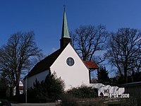
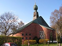
St. Gertrud Church
The St. Gertrud Church was built between 1909 and 1910 according to the plans of the Berlin architects Peter Juergensen and Jürgen Bachmann for the parish, which St. Jacobi became independent in 1902. The tower covered with a gable roof is unusual. The architecture is influenced by the late Art Nouveau , the interior was removed in 1962.
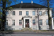
Villa Eschenburg
The Villa Eschenburg near Jerusalemsberg was planned and built by the main architect of Danish classicism Christian Frederik Hansen , the completion (1805) being due to his previous recall to Copenhagen by his friend, the later Lübeck city architect Joseph Christian Lillie . The villa is named after the Eschenburg family from Lübeck .
Today the Brahms Institute of the Lübeck University of Music is located in the building surrounded by Eschenburg Park .

Gate of hope
Between 1936 and 1937 Rudolf Groth built a round building with 48 apartments. The city provided one of the best properties on the east bank of the Wakenitz . The public green area of the apartment block leads into the Marli Park.
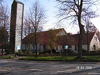
Swedish Church

The former Swedish Church is located on Hafenstrasse near the Burgtorhafen . It was completed in 1904 and served as a place of worship for Swedes who came to Lübeck as seamen until 1968. In the 1980s it was used by the Diakonisches Werk as accommodation for asylum seekers, later rebuilt and has been a private residential building ever since.
Kleverschusskreuz

The Kleverschusskreuz on Roeckstraße, a wayside cross donated by a Lübeck citizen in 1436, commemorates the pilgrims who made their way from Lübeck to Wilsnack in Brandenburg to the Wunderblutkirche before the Reformation . At the fork in two military roads, the cross showed them the direction to today's Arnimstrasse in Brandenburg. The cross owes its name to a post-Reformation legend about the journeyman merchant Hans Klever, who was charged with murder.
Cemetery of honor

Main article: Ehrenfriedhof (Lübeck)
schools
-
Funding Centers (FöZ)
- Maria Montessori School (FöZ Intellectual Development), Stellbrinkstraße, 84 students in 9 classes, 40 supervised
-
Primary schools (GS)
- GS Schule am Stadtpark, Schulstrasse (opened in 1867, name since 1934, ex 1st St. Gertrud School), 236 students in 11 classes
- GS Marli, Heinrichstraße (opened in 1905, ex 2nd St. Gertrud double school), 200 students in 9 classes
- GS Eichholz, Bohlkamp (opened in 1947, ex Eichholz primary school), 164 students in 8 classes
- GS Lauerholz, Holzvogtweg (Karlshof, from 1966) and Waldstrasse branch (Israelsdorf), 340 students in 17 classes
-
Elementary and community schools
- Albert-Schweitzer-Schule, Albert-Schweitzer-Straße (opened in 1956, ex Marli-Süd elementary school), 519 students in 25 classes
- School an der Wakenitz, Dieselstrasse (merger of Anna-Siemsen- and Johannes-Kepler-Schule, since 2009), 582 students in 27 classes
- Geschwister-Prenski-Schule , Travemünder Allee (opened in 1990, name from 1994, ex Otto-Anthes-Volksschule), 766 students in 33 classes
-
high school
- Thomas-Mann-Schule (Lübeck) (Europaschule), Thomas-Mann-Straße (opened 1959), 912 students in 36 classes
Student numbers from the school year 2019/2020
-
Free school
- Free Waldorf School Lübeck (with upper level), Dieselstraße, approx. 650 students
-
Vocational school
- Dorothea-Schlözer-Schule, Am Jerusalemsberg (name since 1970), on the property of the former Pockenhof , 1954 pupils in 100 classes
-
Former schools
- Johannes Kepler School, Am Ährenfeld (opened in 1957, ex Marli Middle School)
- Anna-Siemsen-Schule, Dieselstraße (opened 1953)
Churches
-
Evangelical Lutheran
- St. Gertrud Church, Gustav-Adolf-Straße (consecrated 1910)
- St. Thomas Church, Marlistraße (consecrated 1951)
- St. Christophorus Church, Schäferstrasse (consecrated 1954)
- St. Stephen's Church, (Karlshof) Dornierstrasse (consecrated 1956)
- St. Philip's Church, Schlutuper Strasse (consecrated 1957)
- Dietrich Bonhoeffer Chapel, (Israelsdorf) Wilhelm-Wisser-Weg (consecrated 1966)
- Church of the Resurrection, Marliring (consecrated 1970)
-
Evangelical Free Churches
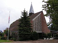
- FeG Lübeck ( Free Evangelical Congregation ), Thomas-Mann-Straße
- Church of Peace ( Baptists ), Täuferstrasse (consecrated 1973)
- Paulus Chapel (Baptists), Brandenbaumer Landstrasse (consecrated as a chapel after renovation in 1986)
-
Roman Catholic
- Heilig-Geist-Kirche, Heilig-Geist-Kamp (consecrated 1965)
- Liebfrauenkirche, Benzstrasse (consecrated 1955)
-
Other denominations
- New Apostolic Church, Diamantweg / Heiweg
- Catholic Apostolic Church, Adolfstrasse
Church of the Resurrection
Dietrich Bonhoeffer Chapel

Friedenskirche

Holy Spirit Church

Church of Our Lady

New Apostolic Church
St. Christopher
St. Gertrude
St. Philip

St. Stephen

St. Thomas


Villa Eschenburg

Park side
Gate of hope


.JPG)
dishes
The Lübeck District Court and the Lübeck Regional Court are located in the district , as well as the Lübeck Labor Court and the Lübeck Social Court . Local and regional courts have their seat in the Lübeck court house .
Urban greenery, forests and nature conservation
St. Gertrud has several parks, in particular the Stadtpark , which opened in 1902 after four years of construction , a twelve-hectare landscape park with ponds and islands on the Galgenbrookswiese in the area of a former Wakenitz bay that was laid out by the city gardener Langenbuch . As part of the development of the entire area between Eschenburg-Strasse and Roeckstrasse, the park was financed from the proceeds from the sale of land and has a large number of native and exotic tree and woody species. It resembles a small arboretum . In its immediate vicinity, the palais-like retirement monasteries, which were built from the bequests of Lübeck merchants before the First World War, stand out.

Stele in memory of the city gardener Langenbuch

City park pond with weeping willow on the island

Frog Prince by Otto Mantzel in the frog pond of the city park
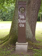
Stele on the Fritz Reuter oak in the city park


But also the Drägerpark and the Eschenburgpark with its sculptures by the animal sculptor Fritz Behn (now installed in the school garden) are worth mentioning. The Burgtorfriedhof , with the listed tombs of Lübeck families, such as that of Emanuel Geibel , Emil Possehl , the Eschenburg , Fehling , Overbeck or the Mann family, and the subsequent cemetery of honor (inaugurated in 1915) based on a design by Harry Maasz are part of the city green of St. Gertrud, which, along with Lauerholz, has the largest forest area in the city. As a lagoon, the Schellbruch on the Trave is a nature reserve of European standing. The Drägerweg leads along the Wakenitz as a hiking trail to Rothenhusen on Lake Ratzeburg .
The privately operated Lübeck zoo existed from 1950 to 2010.
Renaming
-
1914:
- the lower part of Luisenstrasse → Eschenburgstrasse
-
1922:
- Kaiser-Friedrich-Strasse → Rathenau-Strasse
-
circa 1928
- the upper part of Luisenstrasse (from the Glashüttenweg junction) → Forstmeisterweg (this made Luisenstrasse only approx. 300 m long)
-
1933:
- Rathenau-Strasse → Bürgermeister-Neumann-Strasse (reversed after 1945)
-
1936: (reversed after 1945)
- Jerusalem Mountain → Kreuzberg
- Israelsdorfer Allee → Travemünder Allee (not reversed)
- Israelsdorf → Walddorf
- At the Hafenbahn / Glashüttenweg → Curt-Helms-Straße
-
1945: (Krögerland / Eichholz settlement)
- Musketeer Path → In the Musennest
- Grenadierweg → In the owl's nest
- Fusilierweg → Hamsterweg
- Funkerweg → Im Fuchsloch
- Bertholdstrasse → Hirschpass
- Immelmannstrasse → Im Eichholz
- Wolffstrasse → Spieringhorster Strasse
-
1963:
- Burgfeld → Gustav-Radbruch-Platz
-
2019:
- Hindenburgplatz → Republikplatz
Cultural monuments
See also
literature
- Jakobine Kunhardt: Lübeck's suburbs 70 years ago. Memories of an old woman. [2nd, exp. Edition] Lübeck 1898.
- Bernhard Eschenburg : The development of the suburb of St. Gertrud from the sixteenth century to modern times. Lübeck 1905 (also in: Mitteilungen des Verein für Lübeckische Geschichte und Altertumskunde, Issue 12, 1905, pp. 5-60).
- Uwe Müller: St. Gertrud . (Small booklets on city history, edited by the archive of the Hanseatic city of Lübeck , No. 2) Lübeck 1986, ISBN 3-7950-3300-4 .
- Annaluise Höppner: A trip to the summer houses and gardens in the old Lübeck suburbs with a short cultural history along the way. Weiland, Lübeck 1993, ISBN 3-87890-069-5
- Lübeck cemeteries. Burgtor cemetery. Lübeck 2002.
- Hundt, Michael: From the swampy meadow to the ornament of the city. The history of the development of the city park in Lübeck and its peripheral development. In: Zeitschrift des Verein für Lübeckische Geschichte und Altertumskunde 83 (2003), pp. 169–205.
- Jan Zimmermann: St. Gertrud 1860–1945. A photographic foray. Bremen 2007, ISBN 978-3-86108-891-2 .
Sources and Notes
- ^ Ordinance, the boundaries of the suburbs, and the application of the provisions on the conditions affected by it
- ↑ Use from 1897; Expansion in 1902 to 305 hectares
- ↑ On the history of forced labor (1939–1945)
- ↑ The Finland Settlement , accessed October 19, 2018
- ↑ Statistical Office for Hamburg and Schleswig-Holstein Directory of general education schools in Schleswig-Holstein 2019/2020
- ↑ https://www.waldorfschule-luebeck.de/index.php , accessed on May 16, 2019
- ↑ Statistical Office for Hamburg and Schleswig-Holstein: Directory of vocational schools in Schleswig-Holstein 2019/2020
- ^ Metaphius Theodor August Langenbuch (* Eutin September 4, 1842; † May 2, 1907 in Lübeck) presented the plan for the city park in 1897; Execution 1898–1902.
- ↑ This is where the dance hall Luisenlust was located at what later became Eschenburgstrasse 16 , later the Ballhaus Vaterland , and finally the Kaiser Saal disco (last owner / lessee: Heinz Jonas) and the Vaterland restaurant (last host: Aegidius Budig)
- ↑ on the occasion of the 70th birthday of the mayor Johann Georg Eschenburg
- ↑ https://www.ln-online.de/Lokales/Luebeck/Umbennung-Hindenburgplatz-in-Luebeck-heisst-jetzt-wieder-Republikplatz accessed on August 16, 2019
Web links
- District profile 2003 (static information on all districts and districts)
- Map of the city districts and districts with topographical background (PDF file; 519 kB)
- Schellbruch nature reserve
- Finland settlement in Lübeck (private site)
