
Moltkestrasse (Karlsruhe)
| Moltkestrasse | |
|---|---|
|
|
|
 |
|
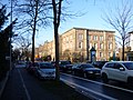
| Pedagogical University, House 3 (1891) | |
| Basic data | |
| place | Karlsruhe |
| District | Downtown West , West City , North City , North West city , Mühlburg |
| Hist. Names | Mr. von Berlichinger Allee, Mühlburger Allee |
| Name received | 1888 |
| Connecting roads | Hans-Thoma-Strasse, Hertzstrasse |
| Cross streets | Wörthstraße, Seminarstraße, Fichtestraße, Schirmerstraße, Reinhold-Frank-Straße, Adenauerring , Riefstahlstraße, Erzbergerstraße, Roggenbach-Straße, Stabelstraße, Weberstraße, Beethovenstraße, Mozartstraße, Freydorfstraße, Siegfriedstraße, Brunhildenstraße, Blücherstraße, Franz-Lust-Straße, Kriemhildenstraße, Guntherstraße Felix-Mottl-Strasse, Kussmaulstrasse, Stösserstrasse, Hertzstrasse |
| Places | Burgunderplatz |
| Numbering system | Orientation numbering |
| Buildings | University of Education, University of Technology and Economics, Academy of Fine Arts (1887–1889), former cadet institute (1889/91), former grenadier barracks, Finance Court Baden-Württemberg (branch, until 2008), Karlsruhe City Clinic , Erich-Kästner -School |
| use | |
| User groups | Pedestrian traffic , bicycle traffic , individual traffic , public transport |
| Technical specifications | |
| Street length | 2.8 km |
The Moltkestraße is a city road in Karlsruhe . It forms a beam starting from the castle tower almost exactly to the west, which runs in a straight line to Burgunderplatz and then turns to the northwest. Historically, long stretches of the road formed the border with the Hardtwald .
course
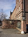
As part of the Karlsruhe fan system, Moltkestrasse connects the palace gardens with the Knielingen district to the west , to which it is continued by Siemensallee. The axis of the street initially runs as a western ray of the radial system offset by a good 4 ° from the east-west axis, starting from the castle tower through the castle garden to the western castle garden gate. There Moltkestrasse begins as an extension of this axis on Hans-Thoma-Strasse, which merges into Willy-Brandt-Allee (formerly the southern part of Linkenheimer Landstrasse). On the southwest corner is the memorial stone for the Federal Prosecutor General Siegfried Buback and his two companions Göbel and Wurster, who were shot here in April 1977 . On the left side of the street, at the site of the former cadet house, is the former General Command of the XIV Army Corps , now the Federal and State Supply Agency (VBL), which has expanded to the opposite side of the street. Beyond Wörthstrasse, on the left side of the street, there is a building complex of the Catholic Church, followed by the St. Dominikus Gymnasium. Opposite is the Moltke cafeteria (built in 2007 by Jürgen Mayer H. ). On the other side of Seminarstraße are two buildings of the college of education , including the monumental House 3 from 1891. On the right side of the street, a little set back on the other side of Engländerplatz, are the youth hostel and youth center. To the west are the buildings of the Karlsruhe University of Applied Sciences - Technology and Economics (formerly the University of Applied Sciences). Here the street crosses the train of Reinhold-Frank-Straße coming from the south, which merges north into the Adenauerring , which bypasses the castle district in a semicircle to the north. On the south side, west of the corner of Reinhold-Frank-Straße (formerly Westendstraße), are the buildings of the former arts and crafts school (now the State Academy of Fine Arts Karlsruhe ) built by Josef Durm from 1887 . Further to the west, tram line 3 ( Nordstadtbahn ) crosses Moltkestrasse on the train of Riefstahlstrasse and Erzbergerstrasse coming from the south . Next to it is the station building of the former Hardtbahn barracks station, which has been vacant since 2008 (No. 31a). Even further to the west on the north side is the former cadet institute (house no. 50) built by Rühle von Lilienstern and Hellwich in 1890/91 , now the Oberfinanzdirektion, a sequence of elongated buildings with additional floors in between. In the west follows the former grenadier barracks (now the Grenadierkaserne administrative center, No. 66–84, with police and customs offices, the State Monument Office and the Leibgrenadier Monument 1870/71). At the intersection with Blücherstraße (south) and its northern extension, Franz-Lust-Straße, tram line 2 turns into Moltkestraße, which follows it to its end and continues in Siemensallee. The Karlsruhe Municipal Clinic follows on the north side of the street . The straight course ends after a short further course at Burgunderplatz. Here Moltkestrasse swings to the northwest. The Erich Kästner School is located in the former New Artillery Barracks on the northeast side . At the intersection with Hertzstrasse, the street turns into Siemensallee, which leads through a large industrial park into the Knielingen district.

Memorial stone for Siegfried Buback and his companions

Moltke cafeteria (admission 2009)

Art academy
Oberfinanzdirektion (former Kadettenanstalt) from the east

Leibgrenadier Monument 1870/71
former grenadier barracks

Karlsruhe Municipal Hospital


literature
- Klaus Schwirkmann: Royal Prussian Cadet Institute Karlsruhe. From the history of today's office building of the regional tax office in Karlsruhe on Moltkestrasse. State of Baden-Württemberg (OFD Karlsruhe), Karlsruhe 1977.
- "Authorities move into barracks / Land invests 40 million marks in former Karlsruhe military facility" , in: Stuttgarter Nachrichten of February 20, 2001.
- Clemens Kieser and Johannes Wilhelm: "Simple, but carefully tested forms". The grenadier barracks in Karlsruhe: New address for the preservation of monuments in North Baden . In: Preservation of monuments in Baden-Württemberg. News bulletin of the State Monuments Office. 3, 2003, doi: 10.11588 / nbdpfbw.2003.3.12382 .
- Ursula Merkel: Leibgrenadierdenkmal (1870/71) , in: Gerlinde Brandenburger / Manfred Großkinsky / Gerhard Kabierske / Ursula Merkel / Beatrice Vierneisel: Monuments, fountains and free sculptures in Karlsruhe 1715–1945, 2nd edition, Karlsruhe 1989, p. 394– 397 (Publications of the Karlsruhe City Archives, Vol. 7).
Web links
- Moltkestrasse in the Stadtwiki Karlsruhe
- Moltkestrasse in the Stadtlexikon Karlsruhe
- Karlsruhe subjects in the Stadtwiki Karlsruhe
- Leibgrenadierdenkmal in the Stadtwiki Karlsruhe
- Leibgrenadierdenkmal in the Stadtlexikon Karlsruhe
- Artillery barracks in the Karlsruhe city dictionary
Individual evidence
- ↑ Georg Dehio (welcomed), Dagmar Zimdars u. a. (Ed.): Handbook of German Art Monuments: Baden-Württemberg I, 1993, Deutscher Kunstverlag, Munich, Berlin, p. 402, ISBN 3-422-03024-7
Coordinates: 49 ° 0 ′ 51 ″ N , 8 ° 23 ′ 53.7 ″ E