
Monsaraz
| Monsaraz | ||||||
|---|---|---|---|---|---|---|
|
||||||
| Basic data | ||||||
| Region : | Alentejo | |||||
| Sub-region : | Alentejo Central | |||||
| District : | Évora | |||||
| Concelho : | Reguengos de Monsaraz | |||||
| Coordinates : | 38 ° 26 ′ N , 7 ° 32 ′ W | |||||
| Residents: | 782 (as of June 30, 2011) | |||||
| Surface: | 88.29 km² (as of January 1, 2010) | |||||
| Population density : | 8.9 inhabitants per km² | |||||
| Postal code : | 7200 | |||||
| politics | ||||||
| Mayor : | Jorge Miguel Nunes | |||||
| Address of the municipal administration: | Junta de Freguesia de Monsaraz Largo Dom Nuno Álvares Pereira, 9 7200-175 Monsaraz |
|||||
| Website: | monsaraz.pt | |||||


Monsaraz is a municipality ( freguesia ) in the district of Reguengos de Monsaraz in the Alentejo in Portugal , with an area of 88.3 km² and 782 inhabitants (June 30, 2011). The population density is 8.9 inhabitants per km². Since 1838 Monsaraz belongs to the district of the same name, 15 km away Reguengos de Monsaraz.
history
The settlement of this area on today's Spanish border goes back to the Bronze Age . Several megalithic monuments in the area attest to this. Even in the times of the Romans and later under the Moors there were human settlements here on the hill.
The town of Monsaraz was recaptured from the Moorish occupation in 1167 , by the army around the leader Geraldo sem Pavor . Monsaraz became the place in 1276 by King Afonso III. appointed. Monsaraz is one of the oldest and best preserved historical places in the Alentejo and an old Templar domain . After the dissolution of the Templar Order in 1312, King Dinis and the Templar João Lourenço from Monsaraz planned to transfer the Templar Order to the Order of Christ . João Lourenço also became his first grandmaster , and under the new name of the Knight of Christ, the association is transformed into the state-sponsoring elite group of Portugal.
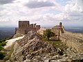
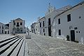
The place still has a continuous closed city wall and many historical buildings have been preserved. Today the place as a municipality is also responsible for the villages of Matriz de Santa Maria da Lagoa, Santiago and São Bartolomeu. Until the completion of the Alqueva reservoir , the place was above the Guardiana River on the Spanish border.
Historical buildings
.jpg)
- Antas of Poço da Gateira , important megalithic complexes
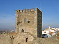
- Castelo de Monsaraz (castle)
- Closed city wall around the village of Vila de Monsaraz
- Main church of Santa Maria da Lagoa
- Pelourinho de Monsaraz main square
- Historic buildings Atalaia de Sao Gens and Torre de Sao Gens do Xarez
- São Bento Chapel
- Church Ermida de Santa Catarina de Monsaraz
- Megalith monuments to Antas by Olival da Pêga
- Megalithic stone formation from Herdade do Xerez or Cromeleque do Xarez
- Menhir da Bulhoa
- Menhir do Outeiro
photos
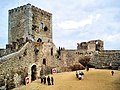
Castelo de Monsaraz
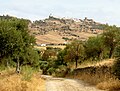
View of Monsaraz

View of Monsaraz

View of Monsaraz on the hill
Monsaraz
View of the tower and city walls of Monsaraz

Monsaraz
Monsaraz

Monsaraz - Pelourinho

Monsaraz

Church in Monsaraz

Source house

Herdade do Xerez megalithic stone formation

Menhir of Outeiro

Menhir of Belhoa / Bulhoa

Anta 1 by Olival da Péga


_Monsaraz.JPG)
.jpg)

.jpg)


.jpg)


Individual evidence
- ↑ www.ine.pt - indicator resident population by place of residence and sex; Decennial in the database of the Instituto Nacional de Estatística
- ↑ Overview of code assignments from Freguesias on epp.eurostat.ec.europa.eu
Web links
- Map of the Freguesia Monsaraz at the Instituto Geográfico do Exército
